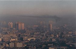
Inversion (meteorology)

Last updated

Temperature inversion in the Lake District, England, forms clouds at a low level beneath clear skies. Temperature inversion in the Lake District.jpg
Temperature inversion in the Lake District, England, forms clouds at a low level beneath clear skies.
Smoke rising in Lochcarron, Scotland, is stopped by an overlying layer of warmer air (2006). SmokeCeilingInLochcarron.jpg
Smoke rising in Lochcarron, Scotland, is stopped by an overlying layer of warmer air (2006).
Smog trapped over the city of Almaty, Kazakhstan during a temperature inversion. Smog over Almaty.jpg
Smog trapped over the city of Almaty, Kazakhstan during a temperature inversion.
Smoke-filled canyons in northern Arizona, 2019. During morning and evening hours, dense smoke often settles in low-lying areas and becomes trapped due to temperature inversions--when a layer within the lower atmosphere acts as a lid and prevents vertical mixing of the air. Steep canyon walls act as a horizontal barrier, concentrating the smoke within the deepest parts of the canyon and increasing the strength of the inversion. Smoke-filled Canyons in AZ from ISS.jpeg
Smoke-filled canyons in northern Arizona, 2019. During morning and evening hours, dense smoke often settles in low-lying areas and becomes trapped due to temperature inversions—when a layer within the lower atmosphere acts as a lid and prevents vertical mixing of the air. Steep canyon walls act as a horizontal barrier, concentrating the smoke within the deepest parts of the canyon and increasing the strength of the inversion.

In meteorology, an inversion is a deviation from the normal change of an atmospheric property with altitude. It almost always refers to an inversion of the air temperature lapse rate, in which case it is called a temperature inversion. Normally, air temperature decreases with an increase in altitude, but during an inversion warmer air is held above cooler air. [2]

Contents

An inversion traps air pollution, such as smog, close to the ground. An inversion can also suppress convection by acting as a "cap". If this cap is broken for any of several reasons, convection of any moisture present can then erupt into violent thunderstorms. Temperature inversion can notoriously result in freezing rain in cold climates.

Normal atmospheric conditions

Usually, within the lower atmosphere (the troposphere) the air near the surface of the Earth is warmer than the air above it, largely because the atmosphere is heated from below as solar radiation warms the Earth's surface, which in turn then warms the layer of the atmosphere directly above it, e.g., by thermals (convective heat transfer). [3] Air temperature also decreases with an increase in altitude because higher air is at lower pressure, and lower pressure results in a lower temperature, following the ideal gas law and adiabatic lapse rate.

Description

Height (y-axis) versus temperature (x-axis) under normal atmospheric conditions (black line). When the layer from 6-8 kilometres (4-5 miles) (designated A-B) descends dry adiabatically , the result is the inversion seen near the ground at 1-2 kilometres (1-1 mile) (C-D). Absinkinversion.png
Height (y-axis) versus temperature (x-axis) under normal atmospheric conditions (black line). When the layer from 6–8 kilometres (4–5 miles) (designated A-B) descends dry adiabatically, the result is the inversion seen near the ground at 1–2 kilometres (1–1 mile) (C-D).
Klagenfurter Becken (Austria) in December 2015: on Mount Goritschnigkogel there is a distinct inverse hoarfrost margin. Reifgrenze.JPG
Klagenfurter Becken (Austria) in December 2015: on Mount Goritschnigkogel there is a distinct inverse hoarfrost margin.

Under the right conditions, the normal vertical temperature gradient is inverted so that the air is colder near the surface of the Earth. This can occur when, for example, a warmer, less-dense air mass moves over a cooler, denser air mass. This type of inversion occurs in the vicinity of warm fronts, and also in areas of oceanic upwelling such as along the California coast in the United States. With sufficient humidity in the cooler layer, fog is typically present below the inversion cap. An inversion is also produced whenever radiation from the surface of the earth exceeds the amount of radiation received from the sun, which commonly occurs at night, or during the winter when the sun is very low in the sky. This effect is virtually confined to land regions as the ocean retains heat far longer. In the polar regions during winter, inversions are nearly always present over land.

A warmer air mass moving over a cooler one can "shut off" any convection which may be present in the cooler air mass: this is known as a capping inversion. However, if this cap is broken, either by extreme convection overcoming the cap or by the lifting effect of a front or a mountain range, the sudden release of bottled-up convective energy—like the bursting of a balloon—can result in severe thunderstorms. Such capping inversions typically precede the development of tornadoes in the Midwestern United States. In this instance, the "cooler" layer is quite warm but is still denser and usually cooler than the lower part of the inversion layer capping it. [4]

Subsidence inversion

An inversion can develop aloft as a result of air gradually sinking over a wide area and being warmed by adiabatic compression, usually associated with subtropical high-pressure areas. [5] A stable marine layer may then develop over the ocean as a result. As this layer moves over progressively warmer waters, however, turbulence within the marine layer can gradually lift the inversion layer to higher altitudes, and eventually even pierce it, producing thunderstorms, and under the right circumstances, tropical cyclones. The accumulated smog and dust under the inversion quickly taints the sky reddish, easily seen on sunny days.

Atmospheric consequences

A Fata Morgana (or mirage) of a ship is due to an inversion (2008). Superior mirage of a boat 2.jpg
A Fata Morgana (or mirage) of a ship is due to an inversion (2008).
Winter smoke in Shanghai, China, with a clear border-layer for the vertical air-spread (1993). Sha1993 smog wkpd.jpg
Winter smoke in Shanghai, China, with a clear border-layer for the vertical air-spread (1993).
Thermal inversion in urban environment Thermal Inversion in Urban Environment.png
Thermal inversion in urban environment
A temperature inversion in Bratislava, Slovakia, viewing the top of Novy Most (2005). Bratislava Temperature inversion1 2005-Nov-11.jpg
A temperature inversion in Bratislava, Slovakia, viewing the top of Nový Most (2005).
Inversion-created smog in Nowa Ruda, Poland, 2017 2017 Smog nad Nowa Ruda.jpg
Inversion-created smog in Nowa Ruda, Poland, 2017

Temperature inversions stop atmospheric convection (which is normally present) from happening in the affected area and can lead to high concentrations of atmospheric pollutants. Cities especially suffer from the effects of temperature inversions because they both produce more atmospheric pollutants and have higher thermal masses than rural areas, resulting in more frequent inversions with higher concentrations of pollutants. The effects are even more pronounced when a city is surrounded by hills or mountains since they form an additional barrier to air circulation. During a severe inversion, trapped air pollutants form a brownish haze that can cause respiratory problems. The Great Smog of 1952 in London, England, is one of the most serious examples of such an inversion. It was blamed for an estimated 10,000 to 12,000 deaths. [6]

Sometimes the inversion layer is at a high enough altitude that cumulus clouds can condense but can only spread out under the inversion layer. This decreases the amount of sunlight reaching the ground and prevents new thermals from forming. As the clouds disperse, sunny weather replaces cloudiness in a cycle that can occur more than once a day.

Wave propagation

Light

As the temperature of air increases, the index of refraction of air decreases, a side effect of hotter air being less dense. Normally this results in distant objects being shortened vertically, an effect that is easy to see at sunset when the sun is visible as an oval. In an inversion, the normal pattern is reversed, and distant objects are instead stretched out or appear to be above the horizon, leading to the phenomenon known as a Fata Morgana or mirage.

Inversions can magnify the so-called "green flash"—a phenomenon occurring at sunrise or sunset, usually visible for a few seconds, in which the sun's green light is isolated due to dispersion. [7] The shorter wavelength is refracted most, with the blue component of sunlight "completely scattered out by Rayleigh scattering", making green the first or last light from the upper rim of the solar disc to be seen. [8]

Radio waves

Very high frequency radio waves can be refracted by inversions, making it possible to hear FM radio or watch VHF low-band television broadcasts from long distances on foggy nights. The signal, which would normally be refracted up and away into space, is instead refracted down towards the earth by the temperature-inversion boundary layer. This phenomenon is called tropospheric ducting. Along coastlines during Autumn and Spring, due to multiple stations being simultaneously present because of reduced propagation losses, many FM radio stations are plagued by severe signal degradation disrupting reception. In higher frequencies such as microwaves, such refraction causes multipath propagation and fading.

Sound

When an inversion layer is present, if a sound or explosion occurs at ground level, the sound wave is refracted by the temperature gradient (which affects sound speed) and returns to the ground. The sound, therefore, travels much better than normal. This is noticeable in areas around airports, where the sound of aircraft taking off and landing often can be heard at greater distances around dawn than at other times of day, and inversion thunder which is significantly louder and travels further than when it is produced by lightning strikes under normal conditions. [9]

Shock waves

The shock wave from an explosion can be reflected by an inversion layer in much the same way as it bounces off the ground in an air-burst and can cause additional damage as a result. This phenomenon killed two people in the Soviet RDS-37 nuclear test when a building collapsed. [10] [11]

See also

Related Research Articles

<span class="mw-page-title-main">Stratosphere</span> Layer of the atmosphere above the troposphere

The stratosphere is the second layer of the atmosphere of Earth, located above the troposphere and below the mesosphere. The stratosphere is an atmospheric layer composed of stratified temperature layers, with the warm layers of air high in the sky and the cool layers of air in the low sky, close to the planetary surface of the Earth. The increase of temperature with altitude is a result of the absorption of the Sun's ultraviolet (UV) radiation by the ozone layer. The temperature inversion is in contrast to the troposphere, near the Earth's surface, where temperature decreases with altitude.

<span class="mw-page-title-main">Mirage</span> Naturally occurring optical phenomenon

A mirage is a naturally-occurring optical phenomenon in which light rays bend via refraction to produce a displaced image of distant objects or the sky. The word comes to English via the French (se) mirer, from the Latin mirari, meaning "to look at, to wonder at".

<span class="mw-page-title-main">Fog</span> Atmospheric phenomenon

Fog is a visible aerosol consisting of tiny water droplets or ice crystals suspended in the air at or near the Earth's surface. Fog can be considered a type of low-lying cloud usually resembling stratus, and is heavily influenced by nearby bodies of water, topography, and wind conditions. In turn, fog affects many human activities, such as shipping, travel, and warfare.

<span class="mw-page-title-main">Wind shear</span> Difference in wind speed or direction over a short distance

Wind shear, sometimes referred to as wind gradient, is a difference in wind speed and/or direction over a relatively short distance in the atmosphere. Atmospheric wind shear is normally described as either vertical or horizontal wind shear. Vertical wind shear is a change in wind speed or direction with a change in altitude. Horizontal wind shear is a change in wind speed with a change in lateral position for a given altitude.

<span class="mw-page-title-main">Capping inversion</span> Elevated inversion layer that caps the part of the atmosphere closest to the ground

A capping inversion is an elevated inversion layer that caps a convective planetary boundary layer.

<span class="mw-page-title-main">Convection cell</span>

In the field of fluid dynamics, a convection cell is the phenomenon that occurs when density differences exist within a body of liquid or gas. These density differences result in rising and/or falling currents, which are the key characteristics of a convection cell. When a volume of fluid is heated, it expands and becomes less dense and thus more buoyant than the surrounding fluid. The colder, denser part of the fluid descends to settle below the warmer, less-dense fluid, and this causes the warmer fluid to rise. Such movement is called convection, and the moving body of liquid is referred to as a convection cell. This particular type of convection, where a horizontal layer of fluid is heated from below, is known as Rayleigh–Bénard convection. Convection usually requires a gravitational field, but in microgravity experiments, thermal convection has been observed without gravitational effects.

Anomalous propagation includes different forms of radio propagation due to an unusual distribution of temperature and humidity with height in the atmosphere. While this includes propagation with larger losses than in a standard atmosphere, in practical applications it is most often meant to refer to cases when signal propagates beyond normal radio horizon.

<span class="mw-page-title-main">Anticyclone</span> Weather phenomenon of high pressure, as opposed to a cyclone

An anticyclone is a weather phenomenon defined as a large-scale circulation of winds around a central region of high atmospheric pressure, clockwise in the Northern Hemisphere and counterclockwise in the Southern Hemisphere as viewed from above. Effects of surface-based anticyclones include clearing skies as well as cooler, drier air. Fog can also form overnight within a region of higher pressure.

<span class="mw-page-title-main">Thermocline</span> Thermal layer in a body of water

A thermocline is a distinct layer based on temperature within a large body of fluid with a high gradient of distinct temperature differences associated with depth. In the ocean, the thermocline divides the upper mixed layer from the calm deep water below.

<span class="mw-page-title-main">Convective available potential energy</span> Measure of instability in the air as a buoyancy force

In meteorology, convective available potential energy, is the integrated amount of work that the upward (positive) buoyancy force would perform on a given mass of air if it rose vertically through the entire atmosphere. Positive CAPE will cause the air parcel to rise, while negative CAPE will cause the air parcel to sink. Nonzero CAPE is an indicator of atmospheric instability in any given atmospheric sounding, a necessary condition for the development of cumulus and cumulonimbus clouds with attendant severe weather hazards.

<span class="mw-page-title-main">Index of meteorology articles</span>

This is a list of meteorology topics. The terms relate to meteorology, the interdisciplinary scientific study of the atmosphere that focuses on weather processes and forecasting.

<span class="mw-page-title-main">Convective inhibition</span>

Convective inhibition is a numerical measure in meteorology that indicates the amount of energy that will prevent an air parcel from rising from the surface to the level of free convection.

<span class="mw-page-title-main">Weather front</span> Boundary separating two masses of air of different densities

A weather front is a boundary separating air masses for which several characteristics differ, such as air density, wind, temperature, and humidity. Disturbed and unstable weather due to these differences often arises along the boundary. For instance, cold fronts can bring bands of thunderstorms and cumulonimbus precipitation or be preceded by squall lines, while warm fronts are usually preceded by stratiform precipitation and fog. In summer, subtler humidity gradients known as dry lines can trigger severe weather. Some fronts produce no precipitation and little cloudiness, although there is invariably a wind shift.

<span class="mw-page-title-main">Convective instability</span> Ability of an air mass to resist vertical motion

In meteorology, convective instability or stability of an air mass refers to its ability to resist vertical motion. A stable atmosphere makes vertical movement difficult, and small vertical disturbances dampen out and disappear. In an unstable atmosphere, vertical air movements tend to become larger, resulting in turbulent airflow and convective activity. Instability can lead to significant turbulence, extensive vertical clouds, and severe weather such as thunderstorms.

The following outline is provided as an overview of and topical guide to air pollution dispersion: In environmental science, air pollution dispersion is the distribution of air pollution into the atmosphere. Air pollution is the introduction of particulates, biological molecules, or other harmful materials into Earth's atmosphere, causing disease, death to humans, damage to other living organisms such as food crops, and the natural or built environment. Air pollution may come from anthropogenic or natural sources. Dispersion refers to what happens to the pollution during and after its introduction; understanding this may help in identifying and controlling it.

<span class="mw-page-title-main">Free convective layer</span>

In atmospheric sciences, the free convective layer (FCL) is the layer of conditional or potential instability in the troposphere. It is a layer in which rising air can experience positive buoyancy (PBE) so that deep, moist convection (DMC) can occur. On an atmospheric sounding, it is the layer between the level of free convection (LFC) and the equilibrium level (EL). The FCL is important to a variety of convective processes and to severe thunderstorm forecasting.

<span class="mw-page-title-main">Atmospheric convection</span> Atmospheric phenomenon

Atmospheric convection is the result of a parcel-environment instability in the atmosphere. Different lapse rates within dry and moist air masses lead to instability. Mixing of air during the day expands the height of the planetary boundary layer, leading to increased winds, cumulus cloud development, and decreased surface dew points. Convection involving moist air masses leads to thunderstorm development, which is often responsible for severe weather throughout the world. Special threats from thunderstorms include hail, downbursts, and tornadoes.

<span class="mw-page-title-main">Atmospheric instability</span> Condition where the Earths atmosphere is generally considered to be unstable

Atmospheric instability is a condition where the Earth's atmosphere is considered to be unstable and as a result local weather is highly variable through distance and time. Atmospheric stability is a measure of the atmosphere's tendency to discourage vertical motion, and vertical motion is directly correlated to different types of weather systems and their severity. In unstable conditions, a lifted thing, such as a parcel of air will be warmer than the surrounding air. Because it is warmer, it is less dense and is prone to further ascent.

<span class="mw-page-title-main">Atmospheric optics</span> Study of the optical characteristics of the atmosphere or products of atmospheric processes

Atmospheric optics is "the study of the optical characteristics of the atmosphere or products of atmospheric processes .... [including] temporal and spatial resolutions beyond those discernible with the naked eye". Meteorological optics is "that part of atmospheric optics concerned with the study of patterns observable with the naked eye". Nevertheless, the two terms are sometimes used interchangeably.

<span class="mw-page-title-main">Glossary of meteorology</span> List of definitions of terms and concepts commonly used in meteorology

This glossary of meteorology is a list of terms and concepts relevant to meteorology and atmospheric science, their sub-disciplines, and related fields.

References

  1. Smoke Filled Canyons, Arizona
  2. Service, NOAA's National Weather. "Glossary – NOAA's National Weather Service". w1.weather.gov. Retrieved January 19, 2017.
  3. Nagle, Garrett, and Paul Guinness. Cambridge International A and AS Level Geography. Hodder Education, 2011. 41. Print.
  4. Oke, Tim; Mills, Gerald; Christen, Andrea; Voogt, James (2017). Urban Climates (1st ed.). Cambridge: Cambridge University Press. pp. 30–35. doi:10.1017/9781139016476. ISBN   978-0-521-84950-0 . Retrieved June 21, 2022.
  5. Wallace and Hobbs (2006) Atmospheric Science: An Introductory Survey
  6. Bell, M.L.; Davis, D.L.; Fletcher, T. (2004). "A Retrospective Assessment of Mortality from the London Smog Episode of 1952: The Role of Influenza and Pollution". Environ Health Perspect . 112 (1, January): 6–8. doi:10.1289/ehp.6539. PMC   1241789 . PMID   14698923.
  7. ben Aroush, Tomer; Boulahjar, Saber; Lipson, Stephen G (December 13, 2017). "Observing the green flash in the laboratory". European Journal of Physics. 39 (1): 2. doi:10.1088/1361-6404/aa90f5. S2CID   125714499 . Retrieved June 21, 2022.
  8. ben Aroush, Tomer; Boulahjar, Saber; Lipson, Stephen G (December 13, 2017). "Observing the green flash in the laboratory". European Journal of Physics. 39 (1): 2. doi:10.1088/1361-6404/aa90f5. S2CID   125714499 . Retrieved June 21, 2022.
  9. Dean A. Pollet and Micheal M. Kordich, User's guide for the Sound Intensity Prediction System (SIPS) as installed at the Naval Explosive Ordnance Disposal Technology Division (Naveodtechdiv). Systems Department February 2000. DTIC.mil
  10. Johnston, Wm. Robert. "RDS-37 Nuclear Test, 1955" . Retrieved April 11, 2014.
  11. "RDS-37: The Soviet Hydrogen Bomb" . Retrieved December 26, 2015.