In meteorology, a cloud is an aerosol consisting of a visible mass of miniature liquid droplets, frozen crystals, or other particles suspended in the atmosphere of a planetary body or similar space. Water or various other chemicals may compose the droplets and crystals. On Earth, clouds are formed as a result of saturation of the air when it is cooled to its dew point, or when it gains sufficient moisture from an adjacent source to raise the dew point to the ambient temperature.

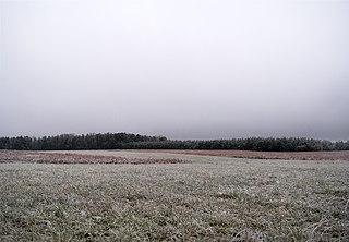
Fog is a visible aerosol consisting of tiny water droplets or ice crystals suspended in the air at or near the Earth's surface. Fog can be considered a type of low-lying cloud usually resembling stratus and is heavily influenced by nearby bodies of water, topography, and wind conditions. In turn, fog affects many human activities, such as shipping, travel, and warfare.

Altocumulus is a middle-altitude cloud genus that belongs mainly to the stratocumuliform physical category, characterized by globular masses or rolls in layers or patches – the individual elements being larger and darker than those of cirrocumulus and smaller than those of stratocumulus. However, if the layers become tufted in appearance due to increased airmass instability, then the altocumulus clouds become more purely cumuliform in structure. Like other cumuliform and stratocumuliform clouds, altocumulus signifies convection. A sheet of partially conjoined altocumulus perlucidus is sometimes found preceding a weakening warm front, where the altostratus is starting to fragment, resulting in patches of altocumulus perlucidus between the areas of altostratus. Altocumulus is also commonly found between the warm and cold fronts in a depression, although this is often hidden by lower clouds.

Altostratus is a middle-altitude cloud genus made up of water droplets, ice crystals, or a mixture of the two. Altostratus clouds are formed when large masses of warm, moist air rise, causing water vapor to condense. Altostratus clouds are usually gray or blueish featureless sheets, although some variants have wavy or banded bases. The sun can be seen through thinner altostratus clouds, but thicker layers can be quite opaque.

A stratocumulus cloud, occasionally called a cumulostratus, belongs to a genus-type of clouds characterized by large dark, rounded masses, usually in groups, lines, or waves, the individual elements being larger than those in altocumulus, and the whole being at a lower height, usually below 2,000 metres (6,600 ft). Weak convective currents create shallow cloud layers because of drier, stable air above preventing continued vertical development. Historically, in English, this type of cloud has been referred to as a twain cloud for being a combination of two types of clouds.

A nimbostratus cloud is a multilevel, amorphous, nearly uniform, and often dark-grey cloud that usually produces continuous rain, snow, or sleet, but no lightning or thunder.

Cirrostratus is a high-altitude, very thin, generally uniform stratiform genus-type of cloud. It is made out of ice-crystals, which are pieces of frozen water. It is difficult to detect and it can make halos. These are made when the cloud takes the form of thin cirrostratus nebulosus. The cloud has a fibrous texture with no halos if it is thicker cirrostratus fibratus. On the approach of a frontal system, the cirrostratus often begins as nebulous and turns to fibratus. If the cirrostratus begins as fragmented of clouds in the sky it often means the front is weak. Cirrostratus is usually located above 5.5 km (18,000 ft). Its presence indicates a large amount of moisture in the upper troposphere. Clouds resembling cirrostratus occasionally form in polar regions of the lower stratosphere. Polar stratospheric clouds can take on this appearance when composed of tiny supercooled droplets of water or nitric acid.
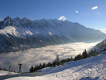
Stratus clouds are low-level clouds characterized by horizontal layering with a uniform base, as opposed to convective or cumuliform clouds formed by rising thermals. The term stratus describes flat, hazy, featureless clouds at low altitudes varying in color from dark gray to nearly white. The word stratus comes from the Latin prefix Strato-, meaning "layer". Stratus clouds may produce a light drizzle or a small amount of snow. These clouds are essentially above-ground fog formed either through the lifting of morning fog or through cold air moving at low altitudes. Some call these clouds "high fog" for their fog-like form.

Mist is a phenomenon caused by small droplets of water suspended in the cold air, usually by condensation. Physically, it is an example of a dispersion. It is most commonly seen where water vapor in warm, moist air meets sudden cooling, such as in exhaled air in the winter, or when throwing water onto the hot stove of a sauna. It can be created artificially with aerosol canisters if the humidity and temperature conditions are right. It can also occur as part of natural weather, when humid air cools rapidly, notably when the air comes into contact with surfaces that are much cooler than the air.
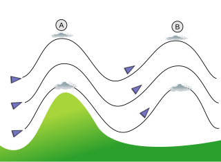
In meteorology, lee waves are atmospheric stationary waves. The most common form is mountain waves, which are atmospheric internal gravity waves. These were discovered in 1933 by two German glider pilots, Hans Deutschmann and Wolf Hirth, above the Giant Mountains. They are periodic changes of atmospheric pressure, temperature and orthometric height in a current of air caused by vertical displacement, for example orographic lift when the wind blows over a mountain or mountain range. They can also be caused by the surface wind blowing over an escarpment or plateau, or even by upper winds deflected over a thermal updraft or cloud street.

Cloud physics is the study of the physical processes that lead to the formation, growth and precipitation of atmospheric clouds. These aerosols are found in the troposphere, stratosphere, and mesosphere, which collectively make up the greatest part of the homosphere. Clouds consist of microscopic droplets of liquid water, tiny crystals of ice, or both, along with microscopic particles of dust, smoke, or other matter, known as condensation nuclei. Cloud droplets initially form by the condensation of water vapor onto condensation nuclei when the supersaturation of air exceeds a critical value according to Köhler theory. Cloud condensation nuclei are necessary for cloud droplets formation because of the Kelvin effect, which describes the change in saturation vapor pressure due to a curved surface. At small radii, the amount of supersaturation needed for condensation to occur is so large, that it does not happen naturally. Raoult's law describes how the vapor pressure is dependent on the amount of solute in a solution. At high concentrations, when the cloud droplets are small, the supersaturation required is smaller than without the presence of a nucleus.

June Gloom is a mainly Southern California term for a weather pattern that results in cloudy, overcast skies with cool temperatures during the late spring and early summer. While it is most common in the month of June, it can occur in surrounding months, giving rise to other colloquialisms, such as “Graypril,” “May Gray,” “No-Sky July,” “Fogust”, and “Summer Bummer”. Low-altitude stratus clouds form over the cool water of the California Current, and spread overnight into the coastal regions of California.

Cumulus mediocris is a low to middle level cloud with some vertical extent of the genus cumulus, larger in vertical development than Cumulus humilis. It also may exhibit small protuberances from the top and may show the cauliflower form characteristic of cumulus clouds. Cumulus mediocris clouds do not generally produce precipitation of more than very light intensity, but can further advance into clouds such as Cumulus congestus or Cumulonimbus, which do produce precipitation and severe storms.

A marine layer is an air mass that develops over the surface of a large body of water, such as an ocean or large lake, in the presence of a temperature inversion. The inversion itself is usually initiated by the cooling effect caused when cold water on the surface of the ocean interacts with a comparatively warm air mass.
Overcast or overcast weather, as defined by the World Meteorological Organization, is the meteorological condition of clouds obscuring at least 95% of the sky. However, the total cloud cover must not be entirely due to obscuring phenomena near the surface, such as fog.

A homogenitus, anthropogenic or artificial cloud is a cloud induced by human activity. Although most clouds covering the sky have a purely natural origin, since the beginning of the Industrial Revolution, the use of fossil fuels and water vapor and other gases emitted by nuclear, thermal and geothermal power plants yield significant alterations of the local weather conditions. These new atmospheric conditions can thus enhance cloud formation.
A cloud étage is a meteorological term used to delimit any one of three main altitude levels in the troposphere where certain cloud types usually form. The term is derived from the French word which means floor or storey, as in the floor of a multi-storey building. With the exception of the low étage, the altitude range of each level varies according to latitude from Earth's equator to the arctic and antarctic regions at the poles.
This glossary of meteorology is a list of terms and concepts relevant to meteorology and atmospheric science, their sub-disciplines, and related fields.