
In meteorology, an inversion is a phenomenon in which a layer of warmer air overlies cooler air. Normally, air temperature gradually decreases as altitude increases, but this relationship is reversed in an inversion.

A thunderstorm, also known as an electrical storm or a lightning storm, is a storm characterized by the presence of lightning and its acoustic effect on the Earth's atmosphere, known as thunder. Relatively weak thunderstorms are sometimes called thundershowers. Thunderstorms occur in a type of cloud known as a cumulonimbus. They are usually accompanied by strong winds and often produce heavy rain and sometimes snow, sleet, or hail, but some thunderstorms produce little precipitation or no precipitation at all. Thunderstorms may line up in a series or become a rainband, known as a squall line. Strong or severe thunderstorms include some of the most dangerous weather phenomena, including large hail, strong winds, and tornadoes. Some of the most persistent severe thunderstorms, known as supercells, rotate as do cyclones. While most thunderstorms move with the mean wind flow through the layer of the troposphere that they occupy, vertical wind shear sometimes causes a deviation in their course at a right angle to the wind shear direction.

A supercell is a thunderstorm characterized by the presence of a mesocyclone, a deep, persistently rotating updraft. Due to this, these storms are sometimes referred to as rotating thunderstorms. Of the four classifications of thunderstorms, supercells are the overall least common and have the potential to be the most severe. Supercells are often isolated from other thunderstorms, and can dominate the local weather up to 32 kilometres (20 mi) away. They tend to last 2–4 hours.

Mammatus is a cellular pattern of pouches hanging underneath the base of a cloud, typically a cumulonimbus raincloud, although they may be attached to other classes of parent clouds. The name mammatus is derived from the Latin mamma.

A dry line is a line across a continent that separates moist air and dry air. One of the most prominent examples of such a separation occurs in central North America, especially Texas, Oklahoma, and Kansas, where the moist air from the Gulf of Mexico meets dry air from the desert south-western states. The dry line is an important factor in severe weather frequency in the Great Plains of North America. It typically lies north-south across the High Plains states in the warm sector of an extratropical cyclone and stretches into the Canadian Prairies during the spring and early summer. The dry line is also important for severe convective storms in other regions of the world, such as northern India and Southern Africa. In general, thunderstorms and other forms of severe weather occur on the moist side of the dryline.

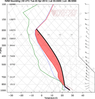
In meteorology, convective available potential energy, is a measure of the capacity of the atmosphere to support upward air movement that can lead to cloud formation and storms. Some atmospheric conditions, such as very warm, moist, air in an atmosphere that cools rapidly with height, can promote strong and sustained upward air movement, possibly stimulating the formation of cumulus clouds or cumulonimbus. In that situation the potential energy of the atmosphere to cause upward air movement is very high, so CAPE would be high and positive. By contrast, other conditions, such as a less warm air parcel or a parcel in an atmosphere with a temperature inversion have much less capacity to support vigorous upward air movement, thus the potential energy level (CAPE) would be much lower, as would the probability of thunderstorms.

Cyclogenesis is the development or strengthening of cyclonic circulation in the atmosphere. Cyclogenesis is an umbrella term for at least three different processes, all of which result in the development of some sort of cyclone, and at any size from the microscale to the synoptic scale.

An outflow boundary, also known as a gust front, is a storm-scale or mesoscale boundary separating thunderstorm-cooled air (outflow) from the surrounding air; similar in effect to a cold front, with passage marked by a wind shift and usually a drop in temperature and a related pressure jump. Outflow boundaries can persist for 24 hours or more after the thunderstorms that generated them dissipate, and can travel hundreds of kilometers from their area of origin. New thunderstorms often develop along outflow boundaries, especially near the point of intersection with another boundary. Outflow boundaries can be seen either as fine lines on weather radar imagery or else as arcs of low clouds on weather satellite imagery. From the ground, outflow boundaries can be co-located with the appearance of roll clouds and shelf clouds.
This is a list of meteorology topics. The terms relate to meteorology, the interdisciplinary scientific study of the atmosphere that focuses on weather processes and forecasting.

Convective inhibition is a numerical measure in meteorology that indicates the amount of energy that will prevent an air parcel from rising from the surface to the level of free convection.

Cumulus congestus or towering cumulus clouds are a species of cumulus that can be based in the low- to middle-height ranges. They achieve considerable vertical development in areas of deep, moist convection. They are an intermediate stage between cumulus mediocris and cumulonimbus, sometimes producing rainshowers, snow, or ice pellets. Precipitation that evaporates before reaching the surface is virga.
In meteorology, convective instability or stability of an air mass refers to its ability to resist vertical motion. A stable atmosphere makes vertical movement difficult, and small vertical disturbances dampen out and disappear. In an unstable atmosphere, vertical air movements tend to become larger, resulting in turbulent airflow and convective activity. Instability can lead to significant turbulence, extensive vertical clouds, and severe weather such as thunderstorms.

An overshooting top is a dome-like protrusion shooting out of the top of the anvil of a thunderstorm and into the lower stratosphere. When an overshooting top is present for 10 minutes or longer, it is a strong indication that the storm is severe.

An air-mass thunderstorm, also called an "ordinary", "single cell", "isolated" or "garden variety" thunderstorm, is a thunderstorm that is generally weak and usually not severe. These storms form in environments where at least some amount of Convective Available Potential Energy (CAPE) is present, but with very low levels of wind shear and helicity. The lifting source, which is a crucial factor in thunderstorm development, is usually the result of uneven heating of the surface, though they can be induced by weather fronts and other low-level boundaries associated with wind convergence. The energy needed for these storms to form comes in the form of insolation, or solar radiation. Air-mass thunderstorms do not move quickly, last no longer than an hour, and have the threats of lightning, as well as showery light, moderate, or heavy rainfall. Heavy rainfall can interfere with microwave transmissions within the atmosphere.

The lifted index (LI) is the temperature difference between the environment Te(p) and an air parcel lifted adiabatically Tp(p) at a given pressure height in the troposphere of the atmosphere, usually 500 hPa (mb). The temperature is measured in Celsius. When the value is positive, the atmosphere is stable and when the value is negative, the atmosphere is unstable.

In atmospheric sciences, the free convective layer (FCL) is the layer of conditional or potential instability in the troposphere. It is a layer in which rising air can experience positive buoyancy (PBE) so that deep, moist convection (DMC) can occur. On an atmospheric sounding, it is the layer between the level of free convection (LFC) and the equilibrium level (EL). The FCL is important to a variety of convective processes and to severe thunderstorm forecasting.

Atmospheric convection is the result of a parcel-environment instability in the atmosphere. Different lapse rates within dry and moist air masses lead to instability. Mixing of air during the day expands the height of the planetary boundary layer, leading to increased winds, cumulus cloud development, and decreased surface dew points. Convection involving moist air masses leads to thunderstorm development, which is often responsible for severe weather throughout the world. Special threats from thunderstorms include hail, downbursts, and tornadoes.
Atmospheric instability is a condition where the Earth's atmosphere is considered to be unstable and as a result local weather is highly variable through distance and time. Atmospheric instability encourages vertical motion, which is directly correlated to different types of weather systems and their severity. For example, under unstable conditions, a lifted parcel of air will find cooler and denser surrounding air, making the parcel prone to further ascent, in a positive feedback loop.

A cold front is the leading edge of a cooler mass of air at ground level that replaces a warmer mass of air and lies within a pronounced surface trough of low pressure. It often forms behind an extratropical cyclone, at the leading edge of its cold air advection pattern—known as the cyclone's dry "conveyor belt" flow. Temperature differences across the boundary can exceed 30 °C (54 °F) from one side to the other. When enough moisture is present, rain can occur along the boundary. If there is significant instability along the boundary, a narrow line of thunderstorms can form along the frontal zone. If instability is weak, a broad shield of rain can move in behind the front, and evaporative cooling of the rain can increase the temperature difference across the front. Cold fronts are stronger in the fall and spring transition seasons and are weakest during the summer.

This glossary of meteorology is a list of terms and concepts relevant to meteorology and atmospheric science, their sub-disciplines, and related fields.

