Conditional symmetric instability

Last updated
Weather radar loop showing intense snow bands (lighter color) due to CSI ahead of a warm front. Northeast Snowfall Impact Scale.gif
Weather radar loop showing intense snow bands (lighter color) due to CSI ahead of a warm front.

Conditional symmetric instability, or CSI, is a form of convective instability in a fluid subject to temperature differences in a uniform rotation frame of reference while it is thermally stable in the vertical and dynamically in the horizontal (inertial stability). The instability in this case develop only in an inclined plane with respect to the two axes mentioned and that is why it can give rise to a so-called "slantwise convection" if the air parcel is almost saturated and moved laterally and vertically in a CSI area. This concept is mainly used in meteorology to explain the mesoscale formation of intense precipitation bands in an otherwise stable region, such as in front of a warm front. [1] [2] The same phenomenon is also applicable to oceanography.

Contents

Principle

Hydrostatic stability

Environmental temperature (in red) and dew point (in green) on a Skew-T log-P diagram. Convective instability animation 12Z 21Z Jan08.gif
Environmental temperature (in red) and dew point (in green) on a Skew-T log-P diagram.

An air particle at a certain altitude will be stable if its adiabatically modified temperature during an ascent is equal to or cooler than the environment. Similarly, it is stable if its temperature is equal or warmer during a descent. In the case where the temperature is equal, the particle will remain at the new altitude, while in the other cases, it will return to its initial level4.

In the diagram on the right, the yellow line represents a raised particle whose temperature remains at first under that of the environment (stable air) which entails no convection. Then in the animation, there is warming surface warming and the raised particle remains warmer than the environment (unstable air). A measure of hydrostatic stability is to record the variation with the vertical of the equivalent potential temperature (): [3]

  • If diminish with altitude leads to unstable airmass
  • If remains the same with altitude leads to neutral airmass
  • If increase with altitude leads to stable airmass.

Inertial Stability

Dark zones are regions of weak inertial stability in atmospheric circulation. Tourbillon total faible.png
Dark zones are regions of weak inertial stability in atmospheric circulation.

In the same way, a lateral displacement of an air particle changes its absolute vorticity . This is given by the sum of the planetary vorticity, , and , the geostrophic (or relative) vorticity of the parcel: [3] [4]

Where :

can be positive, null or negative depending on the conditions in which the move is made. As the absolute vortex is almost always positive on the synoptic scale, one can consider that the atmosphere is generally stable for lateral movement. Inertial stability is low only when is close to zero. Since is always positive, can be satisfied only on the anticyclonic side of a strong maximum of jet stream or in a barometric ridge at altitude, where the derivative velocities in the direction of displacement in the equation give a significant negative value. [5]

The variation of the angular momentum indicate the stability: [3] [5] [6]

Slantwise movement

Three motions but only C is convectively instable. Deplacement dans instabilite symetrique conditionnelle.png
Three motions but only C is convectively instable.

Under certain stable hydrostatic and inertial conditions, slantwise displacement may, however, be unstable when the particle changes air mass or wind regime. The figure on the right shows such a situation. The displacement of the air particle is done with respect to kinetic moment lines () that increase from left to right and equivalent potential temperature () that increase with height.

Lateral movement A

Horizontal accelerations (to the left or right of a surface ) are due to an increase/decrease in the of the environment in which the particle moves. In these cases, the particle accelerates or slows down to adjust to its new environment. Particule A undergoes a horizontal acceleration that gives it positive buoyancy as it moves to colder air and decelerates as it moves to a region of smaller . The particle rises and eventually becomes colder than its new environment. At this point, it has negative buoyancy and begins to descend. In doing so, increases and the particle returns to its original position. [5] [6]

Vertical displacement B

Vertical movements in this case result in negative buoyancy as the particle encounters warmer air ( increases with height) and horizontal acceleration as it moves to larger surfaces . As the particle goes down, its decreases to fit the environment and the particle returns to B. [5] [6]

Slantwise displacement C

Only case C is unstable. Horizontal acceleration combines with a vertical upward disturbance and allows oblique displacement. Indeed, the of the particle is larger than the of the environment. While the momentum of the particle is less than that of the environment. An oblique displacement thus produces a positive buoyancy and an acceleration in the oblique displacement direction which reinforces it. [5]

The condition for having conditional symmetric instability in an otherwise stable situation is therefore that: [3] [5] [6]

Potential effects

Zones of CSI (solid blue) and banded snow (dash green) along the warm front, near the low pressure area. Snowcsi.gif
Zones of CSI (solid blue) and banded snow (dash green) along the warm front, near the low pressure area.

CSI is usually embedded in large areas of vertical upward motion. The ideal situation is a geostrophic flow from the South with wind speeds that increase with height. The environment is well mixed and close to saturation. Since the flow is unidirectional, the u component of the wind can be set equal to zero, which establishes a symmetrical flow perpendicular to the temperature gradient in the air mass. This type of flow is typically found in baroclinic atmospheres with cold air to the west. [6]

The image to the right shows such a situation in winter with CSI associated with negative equivalent potential vorticity () near a warm front. Banded snow forms along the front, near the low pressure area and the CSI.

Slantwise convection

Upward movement in an area of CSI gives clouds, downward movement clears the sky. Instabilite symetrique conditionnelle.svg
Upward movement in an area of CSI gives clouds, downward movement clears the sky.

If a particle is climbing in a CSI zone, it will cool down and the water vapor will condense upon saturation, giving cloud and precipitation by oblique convection. For example, in front of a warm front, the air mass is stable because the mild air overcomes a cold mass. The geostrophic equilibrium brings back any particle moving perpendicularly from the center of the depression towards it. However, an upwardly oblique displacement by synoptic scale upward acceleration in a CSI layer produces parallel bands of heavy rainfall. [6] [7]

Conditional symmetric instability affects a layer that can be thin or very large in the vertical, similar to hydrostatic convection. The thickness of the layer determines the enhancement of convective precipitation within a region otherwise stratiform clouds. [6] As the motion is in an area near saturation, the particle remains very close to the moist adiabatic lapse rate which gives it a limited Convective available potential energy (CAPE). The rate of climb in a slantwise convection zone ranges from a few tens of centimeters per second to a few meters per second. [6] This is usually below the climbing speed limit in a cumulonimbus, i.e. 5 m/s, which gives lightning and limit the occurrence of it with CSI. [6] It is however possible in: [6]

  • The trailing precipitation region of mesoscale convective systems.
  • Wintertime convection because the lower and colder tropopause is helping the ionization of upward moving ice crystals.
  • In the eyewall during the deepening phase of mature hurricanes, although rarely as it is a region symmetrically neutral and is generally free of lightning activity.

Slantwise convection bands have several characteristics: [6]

  1. They are parallel
  2. They are parallel to the thermal wind
  3. They move with the general circulation
  4. The space between the bands is proportional to the thickness of the CSI layer

Subsidence

Conversely, if the particle slide downward, it will warm up and become relatively less saturated, dissipating clouds. The snow produced at higher altitude by the slantwise convection will also sublimate in the descending flow and accelerate. It can give it a speed of descent reaching the 20 m/s. [6] This effect is associated with the descent to the ground of the Sting jet . [8]

Related Research Articles

The barotropic vorticity equation assumes the atmosphere is nearly barotropic, which means that the direction and speed of the geostrophic wind are independent of height. In other words, there is no vertical wind shear of the geostrophic wind. It also implies that thickness contours are parallel to upper level height contours. In this type of atmosphere, high and low pressure areas are centers of warm and cold temperature anomalies. Warm-core highs and cold-core lows have strengthening winds with height, with the reverse true for cold-core highs and warm-core lows.

<span class="mw-page-title-main">Trajectory</span> Path of a moving object

A trajectory or flight path is the path that an object with mass in motion follows through space as a function of time. In classical mechanics, a trajectory is defined by Hamiltonian mechanics via canonical coordinates; hence, a complete trajectory is defined by position and momentum, simultaneously.

In fluid dynamics, Stokes' law is an empirical law for the frictional force – also called drag force – exerted on spherical objects with very small Reynolds numbers in a viscous fluid. It was derived by George Gabriel Stokes in 1851 by solving the Stokes flow limit for small Reynolds numbers of the Navier–Stokes equations.

Equivalent potential temperature, commonly referred to as theta-e, is a quantity that is conserved during changes to an air parcel's pressure, even if water vapor condenses during that pressure change. It is therefore more conserved than the ordinary potential temperature, which remains constant only for unsaturated vertical motions.

The primitive equations are a set of nonlinear partial differential equations that are used to approximate global atmospheric flow and are used in most atmospheric models. They consist of three main sets of balance equations:

  1. A continuity equation: Representing the conservation of mass.
  2. Conservation of momentum: Consisting of a form of the Navier–Stokes equations that describe hydrodynamical flow on the surface of a sphere under the assumption that vertical motion is much smaller than horizontal motion (hydrostasis) and that the fluid layer depth is small compared to the radius of the sphere
  3. A thermal energy equation: Relating the overall temperature of the system to heat sources and sinks

Rossby waves, also known as planetary waves, are a type of inertial wave naturally occurring in rotating fluids. They were first identified by Sweden-born American meteorologist Carl-Gustaf Arvid Rossby. They are observed in the atmospheres and oceans of Earth and other planets, owing to the rotation of Earth or of the planet involved. Atmospheric Rossby waves on Earth are giant meanders in high-altitude winds that have a major influence on weather. These waves are associated with pressure systems and the jet stream. Oceanic Rossby waves move along the thermocline: the boundary between the warm upper layer and the cold deeper part of the ocean.

<span class="mw-page-title-main">Lee wave</span> Atmospheric stationary oscillations

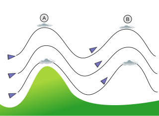
In meteorology, lee waves are atmospheric stationary waves. The most common form is mountain waves, which are atmospheric internal gravity waves. These were discovered in 1933 by two German glider pilots, Hans Deutschmann and Wolf Hirth, above the Krkonoše. They are periodic changes of atmospheric pressure, temperature and orthometric height in a current of air caused by vertical displacement, for example orographic lift when the wind blows over a mountain or mountain range. They can also be caused by the surface wind blowing over an escarpment or plateau, or even by upper winds deflected over a thermal updraft or cloud street.

<span class="mw-page-title-main">Projectile motion</span> Motion of launched objects due to gravity


Projectile motion is a form of motion experienced by an object or particle that is projected in a gravitational field, such as from Earth's surface, and moves along a curved path under the action of gravity only. In the particular case of projectile motion on Earth, most calculations assume the effects of air resistance are passive and negligible. The curved path of objects in projectile motion was shown by Galileo to be a parabola, but may also be a straight line in the special case when it is thrown directly upward or downward. The study of such motions is called ballistics, and such a trajectory is a ballistic trajectory. The only force of mathematical significance that is actively exerted on the object is gravity, which acts downward, thus imparting to the object a downward acceleration towards the Earth’s center of mass. Because of the object's inertia, no external force is needed to maintain the horizontal velocity component of the object's motion. Taking other forces into account, such as aerodynamic drag or internal propulsion, requires additional analysis. A ballistic missile is a missile only guided during the relatively brief initial powered phase of flight, and whose remaining course is governed by the laws of classical mechanics.

<span class="mw-page-title-main">Convective available potential energy</span> Measure of instability in the air as a buoyancy force

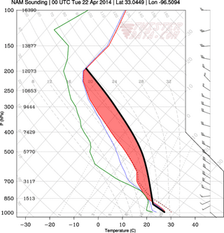
In meteorology, convective available potential energy, is the integrated amount of work that the upward (positive) buoyancy force would perform on a given mass of air if it rose vertically through the entire atmosphere. Positive CAPE will cause the air parcel to rise, while negative CAPE will cause the air parcel to sink. Nonzero CAPE is an indicator of atmospheric instability in any given atmospheric sounding, a necessary condition for the development of cumulus and cumulonimbus clouds with attendant severe weather hazards.

<span class="mw-page-title-main">Cyclogenesis</span> The development or strengthening of cyclonic circulation in the atmosphere

Cyclogenesis is the development or strengthening of cyclonic circulation in the atmosphere. Cyclogenesis is an umbrella term for at least three different processes, all of which result in the development of some sort of cyclone, and at any size from the microscale to the synoptic scale.

The potential temperature of a parcel of fluid at pressure is the temperature that the parcel would attain if adiabatically brought to a standard reference pressure , usually 1,000 hPa (1,000 mb). The potential temperature is denoted and, for a gas well-approximated as ideal, is given by

<span class="mw-page-title-main">Convective inhibition</span>

Convective inhibition is a numerical measure in meteorology that indicates the amount of energy that will prevent an air parcel from rising from the surface to the level of free convection.

In atmospheric dynamics, oceanography, asteroseismology and geophysics, the Brunt–Väisälä frequency, or buoyancy frequency, is a measure of the stability of a fluid to vertical displacements such as those caused by convection. More precisely it is the frequency at which a vertically displaced parcel will oscillate within a statically stable environment. It is named after David Brunt and Vilho Väisälä. It can be used as a measure of atmospheric stratification.

<span class="mw-page-title-main">Convective instability</span> Ability of an air mass to resist vertical motion

In meteorology, convective instability or stability of an air mass refers to its ability to resist vertical motion. A stable atmosphere makes vertical movement difficult, and small vertical disturbances dampen out and disappear. In an unstable atmosphere, vertical air movements tend to become larger, resulting in turbulent airflow and convective activity. Instability can lead to significant turbulence, extensive vertical clouds, and severe weather such as thunderstorms.

In fluid mechanics, potential vorticity (PV) is a quantity which is proportional to the dot product of vorticity and stratification. This quantity, following a parcel of air or water, can only be changed by diabatic or frictional processes. It is a useful concept for understanding the generation of vorticity in cyclogenesis, especially along the polar front, and in analyzing flow in the ocean.

<span class="mw-page-title-main">Shallow water equations</span> Set of partial differential equations that describe the flow below a pressure surface in a fluid

The shallow-water equations (SWE) are a set of hyperbolic partial differential equations that describe the flow below a pressure surface in a fluid. The shallow-water equations in unidirectional form are also called Saint-Venant equations, after Adhémar Jean Claude Barré de Saint-Venant.

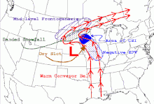
Frontogenesis is a meteorological process of tightening of horizontal temperature gradients to produce fronts. In the end, two types of fronts form: cold fronts and warm fronts. A cold front is a narrow line where temperature decreases rapidly. A warm front is a narrow line of warmer temperatures and essentially where much of the precipitation occurs. Frontogenesis occurs as a result of a developing baroclinic wave. According to Hoskins & Bretherton, there are eight mechanisms that influence temperature gradients: horizontal deformation, horizontal shearing, vertical deformation, differential vertical motion, latent heat release, surface friction, turbulence and mixing, and radiation. Semigeostrophic frontogenesis theory focuses on the role of horizontal deformation and shear.

The omega equation is a culminating result in synoptic-scale meteorology. It is an elliptic partial differential equation, named because its left-hand side produces an estimate of vertical velocity, customarily expressed by symbol , in a pressure coordinate measuring height the atmosphere. Mathematically, , where represents a material derivative. The underlying concept is more general, however, and can also be applied to the Boussinesq fluid equation system where vertical velocity is in altitude coordinate z.

In fluid dynamics, the Burgers vortex or Burgers–Rott vortex is an exact solution to the Navier–Stokes equations governing viscous flow, named after Jan Burgers and Nicholas Rott. The Burgers vortex describes a stationary, self-similar flow. An inward, radial flow, tends to concentrate vorticity in a narrow column around the symmetry axis. At the same time, viscous diffusion tends to spread the vorticity. The stationary Burgers vortex arises when the two effects balance.

A baroclinic instability is a fluid dynamical instability of fundamental importance in the atmosphere and ocean. It can lead to the formation of transient mesoscale eddies, with a horizontal scale of 10-100 km. In contrast, flows on the largest scale in the ocean are described as ocean currents, the largest scale eddies are mostly created by shearing of two ocean currents and static mesoscale eddies are formed by the flow around an obstacle (as seen in the animation on eddy. Mesoscale eddies are circular currents with swirling motion and account for approximately 90% of the ocean's total kinetic energy. Therefore, they are key in mixing and transport of for example heat, salt and nutrients.

References

  1. "Slantwise convection". Meteorology Glossary. American Meteorological Society . Retrieved August 23, 2019.
  2. "Symmetric instability". Meteorology Glossary. American Meteorological Society . Retrieved August 23, 2019.
  3. 1 2 3 4 Charles A. Doswell III. "CSI Physical Discussion". www.cimms.ou.edu. CIMMS. Archived from the original on February 27, 2015. Retrieved August 23, 2019.
  4. "Instabilité barocline". Glossaire météorologique (in French). Météo-France . Retrieved August 23, 2019.
  5. 1 2 3 4 5 6 James T. Moore (2001). "Mesoscale Processes". UCAR. pp. 10–53. Archived from the original (ppt) on December 21, 2014. Retrieved August 23, 2019.
  6. 1 2 3 4 5 6 7 8 9 10 11 12 Schultz, David M.; Schumacher, Philip N. (December 1999). "The Use and Misuse of Conditional Symmetric Instability". Monthly Weather Review . AMS. 127 (12): 2709. doi: 10.1175/1520-0493(1999)127<2709:TUAMOC>2.0.CO;2 . ISSN   1520-0493. S2CID   708227.
  7. Theodore W. Funk; James T. Moore. "Vertical Motion Forcing Mechanisms Responsible for the Production of a Mesoscale very heavy snow band across Northern Kentucky". National Weather Service.
  8. Geraint Vaughan. "Sting Jets" (ppt). eumetrain.org. Retrieved December 18, 2014.