
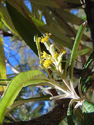
Acacia aneura, commonly known as mulga, is a species of flowering plant in the family Fabaceae and is endemic to inland Australia. It is a variable shrub or small tree with flat, narrowly linear to elliptic phyllodes, cylindrical spikes of bright yellow flowers and more or less flat and straight, leathery pods.
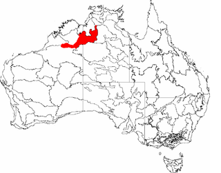
The Ord Victoria Plain, an interim Australian bioregion, is located in the Northern Territory and Western Australia, comprising 12,540,703 hectares.

Western Australia occupies nearly one third of the Australian continent. Due to the size and the isolation of the state, considerable emphasis has been made of these features; it is the second largest administrative territory in the world, after Yakutia in Russia, despite the fact that Australia is only the sixth largest country in the world by area, and no other regional administrative jurisdiction in the world occupies such a high percentage of a continental land mass.

The flora of Australia comprises a vast assemblage of plant species estimated to over 21,000 vascular and 14,000 non-vascular plants, 250,000 species of fungi and over 3,000 lichens. The flora has strong affinities with the flora of Gondwana, and below the family level has a highly endemic angiosperm flora whose diversity was shaped by the effects of continental drift and climate change since the Cretaceous. Prominent features of the Australian flora are adaptations to aridity and fire which include scleromorphy and serotiny. These adaptations are common in species from the large and well-known families Proteaceae (Banksia), Myrtaceae, and Fabaceae.

The Southeast Australia temperate savanna ecoregion is a large area of grassland dotted with eucalyptus trees running north–south across central New South Wales, Australia.
The Mount Lofty woodlands, or the Peppermint Box Grassy Woodland of South Australia, is an ecoregion in South Australia, which includes woodlands, shrublands, and grasslands in the Mount Lofty Ranges, Fleurieu Peninsula, and Kangaroo Island.
The Queanbeyan Nature Reserve is a protected nature reserve that is located in the Southern Tablelands region of New South Wales, in eastern Australia. The 67-hectare (170-acre) reserve is situated approximately 4 kilometres (2.5 mi) west-south-west of the City of Queanbeyan.
Tasmania can be broadly divided into two distinct regions, eastern and western, that exhibit major differences in climate, geology and vegetation. This divide, termed Tyler's Corridor, runs from just south of the northwestern corner, and continues south, cutting roughly down the center of the island. The vegetation changes occur principally due to variations in soil types, which are a result of the geological composition, and the vast difference in climate across the state. Generally, the west has a higher mean rainfall but poor acidic soil while the east has a lower mean rainfall but slightly more fertile soil. This results in a larger proportion of rainforest, moorland and wet sclerophyll vegetation dominating in the west and predominantly dry sclerophyll in the east.

Dodonaea procumbens, commonly known as trailing hop bush or creeping hop-bush, is a species of shrub in the genus Dodonaea found in eastern Australia. It occurs in many places in Australia such as South Australia, New South Wales and Victoria. Although the information on the abundance of this species is limited, it is estimated that about 5,000 plants occur in about 55 wild populations. The species is currently facing many threats such as the expansion of road facilities, the development of residential and agricultural areas, increased grazing regimes, weed invasions, and regimes changing of fire. As a result, it is listed as vulnerable and threatened. Therefore, it is necessary to provide protective solutions for the long-term development and survival of this species.

The Cumberland Plain Woodland, also known as Cumberland Plain Bushland and Western Sydney woodland, is a grassy woodland community found predominantly in Western Sydney, New South Wales, Australia, that comprises an open tree canopy, a groundcover with grasses and herbs, usually with layers of shrubs and/or small trees.

Acacia glandulicarpa, commonly known as the hairy-pod wattle, is a perennial shrub belonging to the genus Acacia and the subgenus Phyllodinea that is native to parts of south eastern Australia.
The Tasmanian temperate forests is a temperate broadleaf and mixed forests ecoregion in Australia. The ecoregion occupies the eastern portion of the island of Tasmania, which lies south of the Australian mainland.
Bedfordia salicina, commonly known as Tasmanian blanketleaf, is an endemic angiosperm of Tasmania, Australia. It is widespread throughout wet sclerophyll forests, moist gullies and intermediate forests and woodlands between wet and dry sclerophyll communities. Bedfordia salicina is abundant at low elevations, on dolerite, sandstone and mudstone substrate, east of Tylers line. Alternating leaves droop down to blanket the stem, coining the species common name, blanketleaf.

The Gippsland Plains Grassy Woodland is an ecological temperate grassland community located in the Gippsland region in southern Victoria, Australia. Stretching from Bairnsdale in the east to the eastern portion of Melbourne in the west, they typify one of Victoria's most threatened and disconnected indigenous ecosystems. The Gippsland Red Gum Grassy Woodland is the most prominent community in the system situated in the centre.

The Iron-grass Natural Temperate Grassland of South Australia is a temperate grassland in the southeast of South Australia that stretches from Orroroo in the north, to Strathalbyn in the south, just straddling the eastern fringes of Adelaide's Mount Lofty Ranges. Listed as Critically Endangered under the EPBC Act, the grasslands predominantly feature Iron-grasses.

The Southern Tablelands Temperate Grassland, formally Natural Temperate Grassland of the Southern Tablelands, is a temperate grassland community situated in the Southern Tablelands and Monaro region of New South Wales, extending into the Australian Capital Territory and the Victorian border. Listed as Endangered under the Environment Protection and Biodiversity Conservation Act 1999, the grassland is dominated by reasonably tall, dense to open tussock grasses.

The Lowland Grassy Woodland, or the Illawarra and South Coast Lowland Grassy Woodland is a grassland-savannah community mostly found in the South Coast region of New South Wales, Australia. Stretching from the southern parts of the Illawarra in the north to the South East Corner in the south, it is an endangered ecological community that lies in a rain shadow area.

Scleranthus fasciculatus, commonly known as spreading knawel, is a rare, spreading, non-woody herb found in the south-eastern states of Australia and introduced to New Zealand. The species is found in dry grassland habitats and requires the maintenance of inter-tussock spaces for its establishment and persistence. A number of anthropogenic factors have contributed to the species decline such as impacts from land clearing, road construction and maintenance, and herbicide application.
