Arnhem Land tropical savanna

Last updated
Arnhem Land tropical savanna
Kakadu (AU), Kakadu National Park, Nadap Lookout -- 2019 -- 4200.jpg
Nadap Lookout in Kakadu National Park
Arnhem Land tropical savanna.jpg
Map of the Arnhem Land tropical savanna ecoregion
Ecology
Realm Australasian
Biome tropical and subtropical grasslands, savannas, and shrublands
Borders Carpentaria tropical savanna and Kimberley tropical savanna
Geography
Area154,737 km2 (59,744 sq mi)
Country Australia
States Northern Territory
Coordinates 12°34′S133°22′E / 12.56°S 133.37°E / -12.56; 133.37 Coordinates: 12°34′S133°22′E / 12.56°S 133.37°E / -12.56; 133.37
Conservation
Conservation status Relatively stable/intact
Protected55,398 km² (36%) [1]

The Arnhem Land tropical savanna is a tropical and subtropical grasslands, savannas, and shrublands ecoregion in Australia's Northern Territory. [2] [3] [4] [5]

Contents

Geography

The ecoregion occupies the peninsula of Arnhem Land and its offshore islands, including the Tiwi Islands, Groote Eylandt, and the Wessel Islands.

Western Arnhem land has rugged sandstone plateaus and gorges. The rest of the peninsula has gentler topography, and includes broad river floodplains and coastal lowlands.

Arnhem Land is bounded on the northwest by the Timor Sea, on the north by the Arafura Sea, and on the east by the Gulf of Carpentaria. The Kimberley tropical savanna ecoregion lies to the southwest, and the Carpentaria tropical savanna to the southeast.

IBRA regions

The ecoregion includes six IBRA regionsArnhem Coast, Arnhem Plateau, Central Arnhem, Darwin Coastal, Pine Creek, and Tiwi Cobourg.

Climate

The ecoregion has a tropical savanna climate. Rainfall is strongly seasonal, with a summer wet season from November to March, and a mostly rainless dry season during the rest of the year. Average annual rainfall ranges from 1200 mm in the south to 1800 mm in the Tiwi Islands in the northwest. Average monthly maximum temperatures are vary from 27º to 33º C. [2]

Flora

The predominant vegetation is woodland of Darwin stringybark (Eucalyptus tetrodonta) and Darwin woollybutt (Eucalyptus miniata). The trees are evergreen and form an open canopy up to 20 metres high. The open canopy supports an understory of tall grass, mostly species of Sorghum growing up to 2.5 metres high. [2]

Areas of monsoon rainforest are found in enclaves with fertile soils, protection from fire, and dry-season water from shallow aquifers or perennial rivers or streams. The rainforest flora is distinct from the predominant eucalyptus-dominated woodlands. The rainforest flora includes evergreen, semi-evergreen, and deciduous trees, and the species mix varies with conditions. Woody vines are abundant, and climb into the tree canopy. Allosyncarpia ternata is a characteristic tree of the Arnhem Land rainforests. Tall-canopied littoral forests and vine thickets are found near the coast. Further inland, evergreen gallery forests grow along rivers, and evergreen forest patches are found at the base of escarpments. [6]

Heathlands grow in areas of the sandstone plateaus with thin, acidic soils, and are home to many endemic species. [2] [6]

Other plant communities include floodplain sedgelands and grasslands, swamp forests dominated by species of Melaleuca , and mangrove forests. [2]

Fauna

Native mammals include the agile wallaby (Macropus agilis), common wallaroo (Osphranter robustus), antilopine kangaroo (Osphranter antilopinus), northern quoll (Dasyurus hallucatus), short-beaked echidna (Tachyglossus aculeatus), northern brushtail possum (Trichosurus arnhemensis), common brushtail possum (Trichosurus vulpecula), rock-haunting ringtail possum (Petropseudes dahli), sugar glider (Petaurus breviceps), dusky rat (Rattus colletti), and pale field rat (Rattus tunneyi).

Endemic species include the Arnhem shovel-nosed snake (Brachyurophis morrisi), the Kakadu dunnart (Sminthopsis bindi), Arnhem Land rock rat (Zyzomys maini), and the Kakadu pebble-mound mouse (Pseudomys calabyi). [2]

Protected areas

A 2017 assessment found that 55,398 km², or 36%, of the ecoregion is in protected areas. [1] Protected areas in the ecoregion include Kakadu National Park, Djukbinj National Park, Nitmiluk National Park, Garig Gunak Barlu National Park, Mary River National Park, and Litchfield National Park. Indigenous protected areas in the ecoregion include Anindilyakwa, Dhimurru, Djelk, Laynhapuy–Stage 1, Marthakal, Warddeken, and the northern portion of South-East Arnhem Land. [7]

Related Research Articles

<span class="mw-page-title-main">Kakadu National Park</span> Protected area in the Northern Territory, Australia

Kakadu National Park is a protected area in the Northern Territory of Australia, 171 km (106 mi) southeast of Darwin. It is a World Heritage Site. Kakadu is also gazetted as a locality, covering the same area as the national park, with 313 people recorded living there in the 2016 Australian census.

<span class="mw-page-title-main">Queensland tropical rain forests</span>

The Queensland tropical rain forests ecoregion covers a portion of the coast of Queensland in northeastern Australia and belonging to the Australasian realm. The forest contains the world's best living record of the major stages in the evolutionary history of the world's land plants, including most of the world's relict species of plants from the ancient supercontinent of Gondwana. The history of the evolution of marsupials and songbirds is also well represented.

<span class="mw-page-title-main">Common brushtail possum</span> Species of marsupial

The common brushtail possum is a nocturnal, semiarboreal marsupial of the family Phalangeridae, native to Australia and naturalised in New Zealand, and the second-largest of the possums.

<span class="mw-page-title-main">Top End</span> Region in the Northern Territory, Australia

The Top End of Australia's Northern Territory is a geographical region encompassing the northernmost section of the Northern Territory, which aside from the Cape York Peninsula is the northernmost part of the Australian continent. It covers a rather vaguely defined area of about 245,000 km² behind the northern coast from the Northern Territory capital of Darwin across to Arnhem Land with the Indian Ocean on the west, the Arafura Sea to the north, and the Gulf of Carpentaria to the east, and with the almost waterless semi-arid interior of Australia to the south, beyond the huge Kakadu National Park.

<span class="mw-page-title-main">Malabar Coast moist forests</span> Ecoregion in India

The Malabar Coast moist forests are a tropical moist broadleaf forest ecoregion of southwestern India.

<span class="mw-page-title-main">Barkly Tableland</span> Region in the Northern Territory, Australia

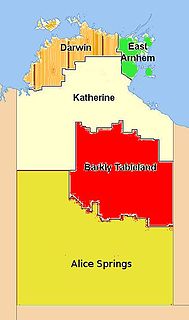
The Barkly Tableland is a rolling plain of grassland in Australia. It runs from the eastern part of the Northern Territory into western Queensland. It is one of the five regions in the Northern Territory and covers 283,648 square kilometres (109,517 sq mi), 21% of the Northern Territory. The Barkly Tableland runs parallel to the southern shore of the Gulf of Carpentaria, from about Mount Isa, Queensland to near Daly Waters.

<span class="mw-page-title-main">Avon Wheatbelt</span> Bioregion in Western Australia

The Avon Wheatbelt is a bioregion in Western Australia. It has an area of 9,517,104 hectares. It is considered part of the larger Southwest Australia savanna ecoregion.

<span class="mw-page-title-main">Rufous owl</span> Species of owl

The rufous owl, also known as the rufous boobook, is a species of owl in the family Strigidae. It was described in 1846 by John Gould, an English ornithologist. Its common name reflects the rufous-coloured feathers that these owls are covered with in adulthood. While it is uncommon, the species has a wide range, including Australia, Indonesia, and Papua New Guinea.

<span class="mw-page-title-main">Geography of the Northern Territory</span> Geography of the Northern Territory region of Australia

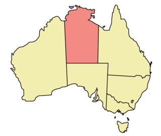
The Northern Territory (NT) occupies the north central part of the continent of Australia. The Northern Territory borders are to the west with Western Australia, the Western Australia border being near the 129° east longitude. The NT to the south with the South Australian border being the 26th parallel south latitude. To the east the NT with the Queensland border along the 138° east longitude.

<span class="mw-page-title-main">Central Range montane rain forests</span> Ecoregion in New Guinea

The Central Range montane rain forests is a tropical moist forest ecoregion on the island of New Guinea. The ecoregion covers the Central Range of the New Guinea Highlands, which extends along the spine of the island. The montane rain forests of the ecoregion are distinct from the surrounding lowland forests, and are home to many endemic plants and animals.

<span class="mw-page-title-main">Timor and Wetar deciduous forests</span> Ecoregion in Indonesia and East Timor

The Timor and Wetar deciduous forests is a tropical dry forest ecoregion in Indonesia and East Timor. The ecoregion includes the islands of Timor, Wetar, Rote, Savu, and adjacent smaller islands.

<span class="mw-page-title-main">North Island temperate forests</span>

The North Island temperate forests, also known as the Northland temperate forests, is a temperate broadleaf and mixed forests ecoregion on New Zealand’s North Island.

<span class="mw-page-title-main">Carpentaria tropical savanna</span> Ecoregion in Australia

The Carpentaria tropical savanna is a tropical and subtropical grasslands, savannas, and shrublands ecoregion in northern Australia.

<span class="mw-page-title-main">Kimberley tropical savanna</span> Terrestrial ecoregion in Western Australia

The Kimberley tropical savanna is a tropical and subtropical grasslands, savannas, and shrublands ecoregion in northwestern Australia, covering portions of Western Australia and the Northern Territory south of the Timor Sea.

<span class="mw-page-title-main">Einasleigh Uplands</span> Bioregion in Queensland, Australia

The Einasleigh Uplands is an interim Australian bioregion, with vegetation consisting of savanna and woodland located on a large plateau in inland Queensland, Australia. It corresponds to the Einasleigh Uplands savanna ecoregion, as identified by the World Wildlife Fund.

<span class="mw-page-title-main">Victoria Plains tropical savanna</span> Ecoregion in Australia

The Victoria Plains tropical savanna is a tropical and subtropical grasslands, savannas, and shrublands ecoregion in northwestern Australia.

<span class="mw-page-title-main">Northeastern Congolian lowland forests</span>

The Northeastern Congolian lowland forests is a tropical moist broadleaf forest ecoregion that spans the Democratic Republic of the Congo and the Central African Republic.

<span class="mw-page-title-main">Southeast Australia temperate forests</span> Terrestrial ecoregion in Australia

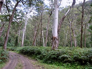
The Southeast Australia temperate forests is a temperate broadleaf and mixed forests ecoregion of south-eastern Australia. It includes the temperate lowland forests of southeastern Australia, at the southern end of the Great Dividing Range. Vegetation ranges from wet forests along the coast to dry forests and woodlands inland.

<span class="mw-page-title-main">Tiwi Cobourg</span> Region in the Northern Territory, Australia

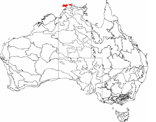
Tiwi Cobourg is an interim Australian bioregion located in the Top End of the Northern Territory of Australia. It has an area of 1,010,580 hectares, which includes the Cobourg Peninsula of Arnhem Land, Croker Island, and the Tiwi Islands. The bioregion is part of the Arnhem Land tropical savanna ecoregion.

References

  1. 1 2 Eric Dinerstein, David Olson, et al. (2017). An Ecoregion-Based Approach to Protecting Half the Terrestrial Realm, BioScience, Volume 67, Issue 6, June 2017, Pages 534–545; Supplemental material 2 table S1b.
  2. 1 2 3 4 5 6 "Arnhem Land tropical savanna". Terrestrial Ecoregions. World Wildlife Fund.
  3. "Map of Ecoregions 2017". Resolve. Retrieved August 20, 2021.
  4. "Arnhem Land tropical savanna". Digital Observatory for Protected Areas. Retrieved August 20, 2021.
  5. "Arnhem Land tropical savanna". The Encyclopedia of Earth. Retrieved 5 May 2022.
  6. 1 2 Bowman, D. M. J. S., G. K. Brown, M. F. Braby, J. R. Brown, L. G. Cook, M. D. Crisp, F. Ford, S. Haberle, J. Hughes, Y. Isagi, L. Joseph, J. McBride, G. Nelson and P. Y. Ladiges (2010). "Biogeography of the Australian monsoon tropics". Journal of Biogeography, February 2010. DOI: 10.1111/j.1365-2699.2009.02210.
  7. UNEP-WCMC (2020). Protected Area Profile for Australia from the World Database of Protected Areas, September 2020. Available at: www.protectedplanet.net