
The Wimmera Southern Mallee subregion is part of the Grampians region in western Victoria. The district covers the dryland farming area south of the range of Mallee scrub, east of the South Australia border and north of the Great Dividing Range. It can also be defined as the land within the social catchment of Horsham, its main settlement.
North Central Victoria is a rural region in the Australian state of Victoria. The region lies to the south of the Victorian/New South Wales border as defined by the Murray River, to the southwest of the Hume region, to the west of the Great Dividing Range contained within the Central Highlands and Victorian Alps, to the north of Greater Melbourne, to the northeast of the Wimmera, and to the east of the Mallee region.

The Division of Wannon is an Australian Electoral Division in the state of Victoria.

The Hopkins River, a perennial river of the Glenelg Hopkins catchment, is located in the Western District of Victoria, Australia.

The Glenelg River, a perennial river of the Glenelg Hopkins catchment, is located in the Australian states of Victoria and South Australia.
The Fitzroy River, a perennial river of the Glenelg Hopkins catchment, is located in the Western District of Victoria, Australia.
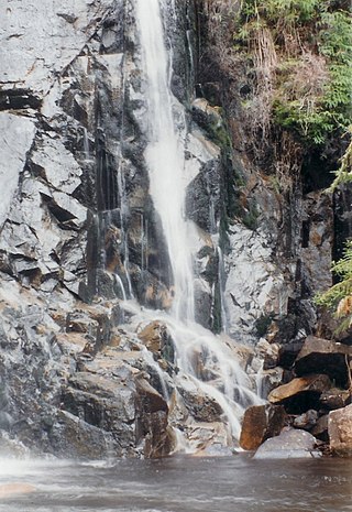
The Nigretta Falls, previously known as the Upper Wannon Falls, are waterfalls located in the Southern Grampians Shire, approximately 16 kilometres (9.9 mi) west of Hamilton, Victoria, Australia. The falls are fed by the Wannon River that has its head waters in the Grampians mountains.

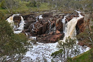
The Wannon Falls are a punchbowl waterfall located in the Southern Grampians Shire, approximately 19 kilometres (12 mi) west of Hamilton, in western Victoria, Australia. The falls are fed by the Wannon River that has its head waters in the Grampians mountains.

The Mount Emu Creek, a perennial creek of the Glenelg Hopkins catchment, is located in the Western District of Victoria, Australia.
The Merri River, a perennial river of the Glenelg Hopkins catchment, is located in the Western District of Victoria, Australia.
The Shaw River, a perennial river of the Glenelg Hopkins catchment, is located in the Western District of Victoria, Australia.
The Eumeralla River is a perennial river of the Glenelg Hopkins catchment, located in the Western District of Victoria, Australia.
The Crawford River or Smoky River, a perennial river of the Glenelg Hopkins catchment, is located in the Western District of Victoria, Australia.
The Wando River, a perennial river of the Glenelg Hopkins catchment, is located in the Western District of Victoria, Australia.
The Dundas River, a perennial river of the Glenelg Hopkins catchment, is located in the Western District of Victoria, Australia.
The Chetwynd River, a perennial river of the Glenelg Hopkins catchment, is located in the Western District of Victoria, Australia.
The Stokes River, a perennial river of the Glenelg Hopkins catchment, is located in the Western District of Victoria, Australia.
The Steavenson River, sometimes incorrectly referred to as Steavensons River, a minor inland perennial river of the Goulburn Broken catchment, part of the Murray-Darling basin, is located in the lower South Eastern Highlands bioregion and Northern Country/North Central regions of the Australian state of Victoria. The headwaters of the Steavenson River rise on the north–western slopes of the Yarra Ranges, below Mount Edgar and descend to flow into the Acheron River near Buxton.

The Grampians is an economic rural region located in the western part of Victoria, Australia. The 48,646-square-kilometre (18,782 sq mi) region lies to the northwest of the western suburbs of Greater Melbourne, to the state's western border with South Australia and includes the Grampians National Park and significant gold mining heritage assets. The Grampians region has two sub-regions, Grampians Central Highlands and Wimmera Southern Mallee.
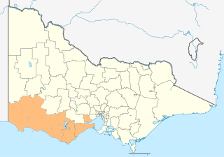
The Barwon South West is an economic rural region located in the southwestern part of Victoria, Australia. The Barwon South West region stretches from the tip of the Queenscliff Heads to the border of South Australia. It is home to Victoria’s largest provincial centre, Geelong and the major centres of Aireys Inlet, Apollo Bay, Camperdown, Colac, Hamilton, Lorne, Port Campbell, Port Fairy, Portland, Torquay and Warrnambool. It draws its name from the Barwon River and the geographic location of the region in the state of Victoria.

