Mount Emu Creek

Last updated

Mount Emu
(Tarnpirr)
Skipton Mount Emu Creek.JPG
The Mount Emu Creek flowing under a bridge that carries the Glenelg Highway, near Skipton.
Australia Victoria relief location map.jpg
Red pog.svg
Location of the Mount Emu Creek mouth
in Victoria
Location
Country Australia
State Victoria
Region Victorian Midlands, Naracoorte Coastal Plain (IBRA), Western District
Local government areas Pyrenees, Ararat, Moyne
Towns Beaufort, Skipton, Darlington, Terang, Panmure
Physical characteristics
Source 
  locationnorth of Trawalla
  coordinates 37°20′27″S143°31′48″E / 37.34083°S 143.53000°E / -37.34083; 143.53000
  elevation405 m (1,329 ft)
Mouth confluence with Hopkins River
  location
near Cudgee, northeast of Warrnambool
  coordinates
38°19′36″S142°38′22″E / 38.32667°S 142.63944°E / -38.32667; 142.63944 Coordinates: 38°19′36″S142°38′22″E / 38.32667°S 142.63944°E / -38.32667; 142.63944
  elevation
28 m (92 ft)
Length250 km (160 mi)
Basin features
River system Glenelg Hopkins catchment
Tributaries 
  leftSpring Hill Creek, Baillie Creek, Blind Creek, Elingamite Creek
  rightTrawalla Creek, Broken Creek (Victoria)
[1]
Bridge & township of Panmure on the Emu Creek, Victoria, c.1888 watercolour by Karl Heffner Bridge & township of Panmure on the Emu Creek.jpg
Bridge & township of Panmure on the Emu Creek, Victoria, c.1888 watercolour by Karl Heffner

The Mount Emu Creek (Aboriginal Australian:Tarnpirr [2] ), a perennial creek of the Glenelg Hopkins catchment, is located in the Western District of Victoria, Australia.

Contents

Course and features

The Mount Emu Creek is a 250-kilometre (160 mi) long and small meandering waterway. It is the longest creek in Victoria. The creek rises near Trawalla and flows generally south by southwest, joined by six tributaries, before reaching its confluence with the Hopkins River, northeast of Warrnambool. The river descends 377 metres (1,237 ft) over its 271-kilometre (168 mi) course. [1] Mount Emu Creek is the major waterway within the Hopkins basin.[ citation needed ] The main drainage area is from numerous small tributaries and gullies to the east and west of the waterway, including Darlington Creek. [3] The main tributary of Mount Emu Creek is Trawalla Creek, that drains the area of highest rainfall within the sub-catchment. Mount Emu Creek has a length of approximately 70 kilometres (43 mi) through this sub-catchment, and passes through the township of Darlington.[ citation needed ]

The waterway starts as a series of creeks and waterways that merge to form the Mount Emu Creek, which flows through areas around Beaufort, Skipton, Darlington, Terang and Panmure. It joins the Hopkins River, which eventually leads out to sea at Warrnambool.

The Baillie Creek drains Lake Burrumbeet and flows into the Mount Emu Creek west of Snake Valley. The Elingamite Creek drains Lake Elingamite and flows into the Mount Emu Creek south of Terang. [4]

The creek is traversed by the Western Highway near Trawalla, the Glenelg Highway at Skipton, the Hamilton Highway at Darlington, and the Princes Highway near Terang.

Fishing

The Mount Emu system is a very popular fishing stream with residents and visitors along its course, where trophy sized trout can be pursued. The creek is regularly stocked with brown trout from the Department of Natural Resources and Environment (with the assistance of the Terang Angling Club). There is also a small population of native brown trout. Trophy size trout are there to be taken but most fish average around 1,000 grams (35 oz). Some of the more popular spots to be fished are McKinnons bridge, Castlecary Road bridge, Ayresford Road and Panmure bridge. Other fish to be caught include redfin, eels, tench, tupong and black fish. [5] In several locations between Pura Pura and Darlington, yellowbelly are known to be caught on worm (no float).

Platypuses

Mount Emu Creek abounds in redfin and is the home of many platypuses. [6] Surveys in 1991 [7] [8] and 1996 [9] confirmed that platypus are breeding successfully right in the heart of Skipton township, where on a bend in the creek at Stewart Park in the centre of town is a platform built on the banks of the creek from which to observe them. [10] An all night research session along the Mount Emu Creek was conducted by the Australian Platypus Conservancy in August 2003, [11] in collaboration with Skipton's Stewart Park Committee. A baby female was one of six platypuses found in the 5-kilometre (3.1 mi) section of the creek. Weighing in at 680 grams (24 oz), the tiny juvenile had probably[ citation needed ] only first ventured out of her burrow a week or so previously. Geoff Williams, a biologist with the Conservancy, said that the youngster was in really good condition and her presence confirmed that successful breeding is taking place in the township. [12]

Murdering Gully massacre

The Murdering Gully massacre occurred in a gully on Mount Emu Creek, where a small stream adjoins from Mérida station (near Camperdown) in early 1839. Between 35 and 40 men, women and children of the Tarnbeere gundidj clan were shot dead by Frederick Taylor and other shepherds for the killing of several sheep. [13] [14]

See also

Related Research Articles

<span class="mw-page-title-main">Warrnambool</span> City in Victoria, Australia

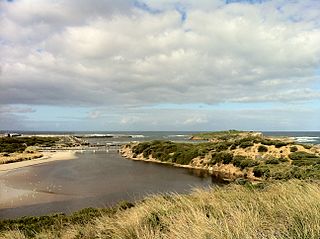
Warrnambool is a city on the south-western coast of Victoria, Australia. At the 2021 census, Warrnambool had a population of 35,743. Situated on the Princes Highway, Warrnambool (Allansford) marks the western end of the Great Ocean Road and the southern end of the Hopkins Highway.

<span class="mw-page-title-main">Terang</span> Town in Victoria, Australia

Terang is a town in the Western District of Victoria, Australia. The town is in the Shire of Corangamite and on the Princes Highway 212 kilometres (132 mi) south west of the state's capital, Melbourne. At the 2006 census, Terang had a population of 1,824. At the 2001 census, Terang had a population of 1,859. The population of Terang has since risen according to the 2011 Census; the population is now 2,348, of which 1,155 are male and 1,193 are female, with the median age being 44.

<span class="mw-page-title-main">Merri Creek</span> River in Victoria, Australia

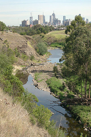
The Merri Creek is a waterway in southern parts of Victoria, Australia, which flows through the northern suburbs of Northcote. It begins near Wallan north of Melbourne and flows south for 70 km until it joins the Yarra River at Dights Falls. The area where the creek meets the river was traditionally the location for large gatherings of the Wurundjeri people and is suspected to have been the location for one of the earliest land treaties in Australia between Indigenous Australians and European settlers.

<span class="mw-page-title-main">Panmure, Victoria</span> Town in Victoria, Australia

Panmure is a small town in the south west of Victoria, Australia. At the 2006 census, Panmure and the surrounding area had a population of 421. Situated on the Princes Highway, the town is half way between Terang and Warrnambool.

<span class="mw-page-title-main">Hopkins River</span> River in Victoria, Australia

The Hopkins River, a perennial river of the Glenelg Hopkins catchment, is located in the Western District of Victoria, Australia.

<span class="mw-page-title-main">Kororoit Creek</span> River in Victoria, Australia

The Kororoit Creek is a watercourse of the Port Phillip catchment, rising in the outer north western suburbs of Melbourne, in the Australian state of Victoria.

Glenelg Highway is a rural highway in south-eastern Australia, linking Mount Gambier with Ballarat. Most of the highway is located within the Western part of the state of Victoria, though a short, 15 km stretch from the South Australia/Victoria state border near Ardno to Glenburnie is located in South Australia. Some maps identify the South Australian stretch as Casterton Road. Major towns along its route include Casterton, Coleraine and Hamilton.

<span class="mw-page-title-main">Skipton, Victoria</span> Town in Victoria, Australia

Skipton is a town in the Western District of Victoria, Australia. The town is situated on the Glenelg Highway 166 kilometres west of the state capital, Melbourne and 52 kilometres south west of the regional centre, Ballarat. Skipton is in the Shire of Corangamite LGA and is on the banks of Mount Emu Creek. At the 2016 census, Skipton had a population of 586, considerably less than the population of 927 at the 2011 census. Skipton is named after Skipton, in Yorkshire, England and is known as "the home of the platypus".

<span class="mw-page-title-main">Woady Yaloak River</span> Perennial river in Victoria, Australia

The Woady Yaloak River is a perennial river of the Corangamite catchment, located in the Western District Lakes region of the Australian state of Victoria.

Lake Burrumbeet is a large but shallow eutrophic lake in central western Victoria, Australia. Located 20 kilometres (12 mi) west of Ballarat and 140 kilometres (87 mi) west of Melbourne, the lake has been progressively emptying since 1997 and was declared completely dry in 2004. It has however in recent years refilled because of good rainfalls, making water sports in the lake once again possible, with recreational jet skiing and boating taking place in the winter of 2010. The lake is a major wetland for the region because of its size and is utilised as a recreational area for boating, fishing and camping.

<span class="mw-page-title-main">Trawalla, Victoria</span> Town in Victoria, Australia

Trawalla is a town in central Western Victoria, Australia, located on the Western Highway, 41 kilometres (25 mi) west of Ballarat and 154 kilometres (96 mi) west of Melbourne, in the Shire of Pyrenees. At the 2006 census, Trawalla and the surrounding agricultural area had a population of 224.

<span class="mw-page-title-main">County of Hampden, Victoria</span> Cadastral in Victoria, Australia

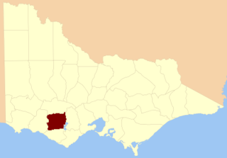
The County of Hampden is one of the 37 counties of Victoria which are part of the cadastral divisions of Australia, used for land titles. The county is in the Western District of Victoria bounded by Lake Corangamite in the east and the Hopkins River in the west. In the north and south the county was bounded approximately by the existing roads, now the Glenelg Highway and the Princes Highway. Larger towns include Terang and Skipton. The county was proclaimed in 1849.

The Fitzroy River, a perennial river of the Glenelg Hopkins catchment, is located in the Western District of Victoria, Australia.

<span class="mw-page-title-main">Girai wurrung</span> Aboriginal Australian people of present-day western Victoria

The Girai wurrung, also spelt Kirrae Wuurong and Kirrae Whurrung, are an Aboriginal Australian people who traditionally occupied the territory between Mount Emu Creek and the Hopkins River up to Mount Hamilton, and the Western Otways from the Gellibrand River to the Hopkins River. The historian Ian D. Clark has reclassified much of the material regarding them in Norman Tindale's compendium under the Djargurd Wurrung, a term reflecting the assumed pre-eminence of one of their clans, the Jacoort/Djargurd.

Mount Warrnambool is a single large scoria cone volcano that is 216 metres (709 ft) high. It is 16 kilometres (10 mi) southwest of Terang, Victoria, Australia. It is visible from the Princes Highway on the way to Warrnambool.

The Merri River, a perennial river of the Glenelg Hopkins catchment, is located in the Western District of Victoria, Australia.

<span class="mw-page-title-main">Liffey River (Tasmania)</span> River in Tasmania, Australia

The Liffey River is a river in Northern Tasmania, Australia.

Darlington is a locality in the Western District of Victoria, Australia. The locality is in the Shire of Corangamite and on the Hamilton Highway, 194 kilometres (121 mi) south west of the state capital, Melbourne. Mount Emu Creek passes through the locality.

References

  1. 1 2 "Map of Mount Emu Creek, VIC". Bonzle Digital Atlas of Australia. Retrieved 22 June 2014.
  2. Clark, Ian. "Aboriginal Placenames - Reconstruction of Aboriginal microtoponymy in western and central Victoria". press-files.anu.edu.au. ANU. Retrieved 16 July 2021.
  3. http://www.glenelg-hopkins.vic.gov.au/?id=subcatchmenth7
  4. Webb, John; Raiber, Matthias; School of Engineering and Mathematical Sciences; Victorian Universities Earth and Environmental Science Conference (18th: 2004: Melbourne, Australia) (2004), Salt lakes and their influence on the salinity of surface waters in Mount Emu Creek and Fiery/Salt Creek, western Victoria, Geological Society of Australia, retrieved 17 February 2022
  5. "Terang Angling Club". linux.gatewaybbs.com.au. Archived from the original on 12 February 2001.
  6. "Reclusive platypuses enjoying fuller rivers". Ballarat Courier. Ballarat, Australia. 7 October 2016.
  7. Scuffins, Martin J; Ballarat University College. Department of Biological and Chemical Sciences (1991), The population status and ecology of the platypus (Ornithorhnychus anatinus) in Mount Emu and Baillies Creeks, Western Victoria, Australia, The Author, retrieved 17 February 2022
  8. Prevett, P. T. (Pat); Stephens, P. (Paul Henry); Marion, Allison; National Estate Grants Program (Australia); University of Ballarat (1994), Status, ecology and behaviour of the platypus, Ornithorhynchus anatinus in Mt. Emu and Baillies Creeks, Victoria, University of Ballarat, retrieved 17 February 2022
  9. Hopf, Terri; University of Ballarat. School of Science (1996), Habitat use by platypus (Ornithorhychus anatinus) at Mt. Emu Creek, Skipton, Victoria, The Author, retrieved 17 February 2022
  10. "6 reasons to visit Skipton". The Age. 3 March 2018. p. 6.
  11. "Still in a Tangle" (PDF). Ripples: Newsletter of the Australian Platypus Conservancy (25): 2. September 2003. Retrieved 17 February 2022.
  12. "This webpage has been moved to WWW". Archived from the original on 2 February 2011. Retrieved 2 December 2009.
  13. "Museum Victoria [ed-online] Encounters". museumvictoria.com.au. Archived from the original on 20 September 2007.
  14. "The vanishing: finding Private Jack.(Insight)", The Age (Melbourne, Australia), Fairfax Media Publications Pty Limited: 21, 10 December 2016, ISSN   0312-6307