
Werribee Gorge State Park is a state park in Victoria, Australia. It is located near Bacchus Marsh and is used by bushwalkers and rock climbers, who are attracted to its views and geological features.

The Werribee River is a perennial river of the Port Phillip catchment that is located on the expansive lowland plain southwest of Melbourne, Victoria, Australia. The headwaters of a tributary, the Lerderderg River, are north of Ballan near Daylesford and it flows across the basalt plain, through the suburb of Werribee to enter Port Phillip. A linear park follows the Werribee River along much of its course. In total the Werribee River completes a journey of approximately 110 kilometres (68 mi).

Mullum Mullum Creek is a creek in the outer eastern suburbs of Melbourne, Victoria, Australia. It is the main watercourse of the Mullum Mullum Valley, a tributary of the Yarra River and Yarra Valley. For tens of thousands of years it was used as a food and tool source sustainably by the Wurundjeri people, Indigenous Australians of the Kulin nation, who spoke variations of the Woiwurrung language group.

The Thomson River, a perennial river of the West Gippsland catchment, is located in the Gippsland region of the Australian state of Victoria.
The Lerderderg Gorge is in Victoria, Australia and largely within the Lerderderg State Park. The Lerderderg River which emerges from the Great Dividing Range has cut a deep gorge as it winds toward the southern plains. It is suggested that the name Lerderderg is perhaps a corruption of the Wurundjeri word "Larderdark," from 'larh' -stone house and 'dark' -peppermint gum.
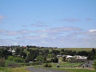
Myrniong is a town in Victoria, Australia. The town is near the Western Freeway, 69 kilometres (43 mi) north west of the state capital, Melbourne and 15 kilometres (9 mi) west of Bacchus Marsh. Situated close by the Lerderderg River, at the 2016 census, Myrniong had a population of 404. The town is in the eastern area of Shire of Moorabool local government area.

Blackwood is a rural village in Victoria, Australia. The township is located on the Lerderderg River, 89 kilometres north-west of the state capital, Melbourne, within the Wombat State Forest. Blackwood is in the Shire of Moorabool local government area and had a population of 387 at the 2021 census.
Lerderderg State Park is a 14,250-hectare park located between Bacchus Marsh and Blackwood, an hour's drive from Melbourne, Australia. The park is part of an Aboriginal cultural landscape in the traditional country of the Wurundjeri People. There are several maintained tracks for walking through the park and camping is allowed.

Warrandyte State Park is a state park, located in Warrandyte, east of Melbourne, Victoria on the banks of the Yarra River and surroundings. The park comprises 586 hectares of remnant bushland in various locations throughout Warrandyte and Wonga Park around Pound Bend, Fourth Hill, Black Flat, Yarra Brae and various other locations in the area. It hosts many significant geographical, environmental, archaeological and historical sites, such as the site of the first gold discovery in Victoria in 1851 and preserves the sites of former gold mines and tunnels. It is a popular destination for school and community groups and is frequented by local bush walkers and hikers.

The Goldfields region of Victoria is a region commonly used but typically defined in both historical geography and tourism geography. The region is also known as the Victorian Golden Triangle.
The major part of the Great Dividing Trail is now re-badged as the Goldfields Track, a hiking and mountain-biking track through the historical Goldfields region of Victoria to the north-west and west of Melbourne. The trail passes along the southernmost parts of Australia's Great Dividing Range. The Goldfields Track, runs from the summit of Mount Buninyong to Bendigo, and is divided into the Eureka Track, Wallaby Track, Dry Diggings Track and Leanganook Track. A separate leg of the Great Dividing Trail, the Lerderderg Track, branches from Daylesford to Bacchus Marsh.
The Thomson River Diversion Tunnel, also known as the Horseshoe Bend Tunnel or the Chinese Tunnel, is located on the Thomson River near the junction with Coopers Creek, approximately 4 kilometres (2.5 mi) south-west of Walhalla, Victoria, Australia. The site is listed on the Victorian Heritage Register and covered by a Heritage Overlay.
The Delegate River Diversion Tunnel is a Victorian gold rush diversion tunnel on the Delegate River in east Gippsland, Victoria, Australia - approximately 70 km north-east of Orbost. The river eventually runs through the township of Delegate, New South Wales. The tunnel is approximately 60 m long and diverts the river away from its original course.

The Lerderderg River diversion tunnel, known as The Tunnel, is located on the Lerderderg River approximately 25 km north-west of Bacchus Marsh, Victoria, Australia. The river flows around a spur in a horseshoe bend. The tunnel was driven through the spur diverting the river and allowing the exposed river bed to be sluiced for alluvial gold.
The Blowhole diversion tunnel is located on the Sailors Creek, Hepburn, Victoria, Australia. The creek flows around a spur in a horseshoe bend. The tunnel was driven through the spur diverting the river and allowing the exposed river bed to be sluiced for alluvial gold. It "was probably built in the early 1860s when Jim Crow Creek was being extensively worked by European and Chinese miners".
The Jordan River, a perennial river of the West Gippsland catchment, is located in the Alpine region of the Australian state of Victoria.

The Howqua River, a minor inland perennial river of the Goulburn Broken catchment, part of the Murray-Darling basin, is located in the Alpine region of the Australian state of Victoria. The headwaters of the Howqua River rise below Mount Howitt in the western slopes of the Victorian Alps, and descend to flow into the Goulburn River within Lake Eildon.
Darley is a suburb of Bacchus Marsh, Victoria, Australia located directly north of the central area across the Western Freeway. It is the most populous locality and earliest settlement (1838) in Bacchus Marsh. At the 2021 census, Darley had a population of 9,190.

The Wombat State Forest is located 50 kilometres (31 mi) west of Melbourne, Victoria, Australia, between Woodend and Daylesford, at the Great Dividing Range. The forest is approximately 70,000 hectares in size and sits upon Ordovician or Cenozoic sediments. The Bullarook Wombat State Forest was proclaimed in 1871.
The Old River is a perennial river of the Port Phillip catchment, located in the Western District region of the Australian state of Victoria.

