
The Shire of Corangamite is a local government area in the Barwon South West region of Victoria, Australia, located in the south-western part of the state. It covers an area of 4,408 square kilometres (1,702 sq mi) and in June 2018 had a population of 16,140. It includes the towns of Camperdown, Terang, Cobden, Timboon, Port Campbell and Skipton. It was formed in 1994 from the amalgamation of the Town of Camperdown, Shire of Hampden, Shire of Heytesbury, and parts of the Shire of Otway, Shire of Mortlake and Shire of Warrnambool.
Terang is a town in the Western District of Victoria, Australia. The town is in the Shire of Corangamite and on the Princes Highway 212 kilometres (132 mi) south west of the state's capital, Melbourne. At the 2006 census, Terang had a population of 1,824. At the 2001 census, Terang had a population of 1,859. The population of Terang has since risen according to the 2011 Census; the population is now 2,348, of which 1,155 are male and 1,193 are female, with the median age being 44.
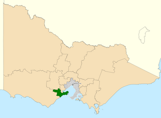
The Division of Corangamite is an Australian electoral division in the state of Victoria. The division was proclaimed in 1900, and was one of the original 65 divisions to be contested at the first federal election. It is named for Lake Corangamite, although the lake no longer falls within the division's boundaries.
Lake Corangamite, a hypersaline endorheic lake, is located near Colac in the Lakes and Craters region of the Victorian Volcanic Plains of south-west Victoria, Australia. The lake's salinity levels have increased dramatically as the lake level has dropped in recent decades. It is Australia's largest permanent saline lake, covering approximately 230 square kilometres (89 sq mi) with a circumference of 150 kilometres (93 mi). It forms part of the Ramsar-listed Western District Lakes wetland site. The Aboriginal name of the lake is recorded as Kronimite.
Lake Purrumbete is a volcanic lake located in the Western District of Victoria, Australia. Lake Purrumbete is approximately 15 km (9.3 mi) east of the town of Camperdown. The lake is in a shallow maar. The water is crystal clear most times of the year as the lake relies totally on its own catchment.

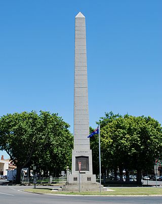
Camperdown is a town in southwestern Victoria, Australia, 190 kilometres (120 mi) west of the state capital, Melbourne. At the 2016 census, Camperdown had a population of 3,369.

Skipton is a town in the Western District of Victoria, Australia. The town is situated on the Glenelg Highway 166 kilometres west of the state capital, Melbourne and 52 kilometres south west of the regional centre, Ballarat. Skipton is in the Shire of Corangamite LGA and is on the banks of Mount Emu Creek. At the 2016 census, Skipton had a population of 586, considerably less than the population of 927 at the 2011 census. Skipton is named after Skipton, in Yorkshire, England and is known as "the home of the platypus". The Aboriginal name is given in colonial reports as Woran.

Lake Connewarre, a shallow estuarine 880-hectare (2,200-acre) lake on the Barwon River, is located on the Bellarine Peninsula southeast of Geelong in the Australian state of Victoria.

The Woady Yaloak River is a perennial river of the Corangamite catchment, located in the Western District Lakes region of the Australian state of Victoria.

Reedy Lake, historically also known as Lake Reedy, is a shallow 5.5-square-kilometre (2.1 sq mi) intermittent freshwater lake or swamp on the lower reaches of the Barwon River, on the Bellarine Peninsula southeast of Geelong in the Australian state of Victoria.
The Ford River is a perennial river of the Corangamite catchment, located in the Otways region of the Australian state of Victoria.
The Calder River is a perennial river of the Corangamite catchment, located in the Otways region of the Australian state of Victoria.
The Geary River is a perennial river of the Corangamite catchment, located in the Otways region of the Australian state of Victoria.
The Elliott River is a perennial river of the Corangamite catchment, located in the Otways region of the Australian state of Victoria.
The Grey River is a perennial river of the Corangamite catchment, located in the Otways region of the Australian state of Victoria.

Lake Beeac, a hypersaline endorheic lake, is located beside the small town of Beeac in the Lakes and Craters region of the Victorian Volcanic Plains of south-west Victoria, in southeastern Australia. The 560-hectare (1,400-acre) lake is situated about 19 kilometres (12 mi) northeast of Colac, and its high salinity gives it a milky-blue colour. The lake is part of the Ramsar-listed Western District Lakes site, and enjoys international recognition of its wetland values and some protection for its waterbirds.

The Yarrowee River is a perennial river of the Corangamite catchment, located in the Central Highlands region of the Australian state of Victoria.
The Western District Lakes of Victoria, in the Western District of Victoria, south-eastern Australia, were recognised on 15 December 1982 as wetlands of international importance by listing under the Ramsar Convention, as Ramsar site no.268.
Butchers Lake is a small salt lake of the Corangamite catchment, located north of Lake Beeac and south of Lake Cundare, in the south-western lakes district of Victoria, Australia.

The Leigh River is a perennial river of the Corangamite catchment, located in the Central Highlands region of the Australian state of Victoria.
