The Murray River is a river in Southeastern Australia. It is Australia's longest river at 2,508 km (1,558 mi) extent. Its tributaries include five of the next six longest rivers of Australia. Together with that of the Murray, the catchments of these rivers form the Murray–Darling basin, which covers about one-seventh the area of Australia. It is widely considered Australia's most important irrigated region.

The Murrumbidgee River is a major tributary of the Murray River within the Murray–Darling basin and the second longest river in Australia. It flows through the Australian state of New South Wales and the Australian Capital Territory, descending 1,500 metres (4,900 ft) over 1,485 kilometres (923 mi), generally in a west-northwesterly direction from the foot of Peppercorn Hill in the Fiery Range of the Snowy Mountains towards its confluence with the Murray River near Boundary Bend.

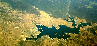
Hume Dam, formerly the Hume Weir, is a major dam across the Murray River downstream of its junction with the Mitta River in the Riverina region of New South Wales, Australia. The dam's purpose includes flood mitigation, hydro-power, irrigation, water supply and conservation. The impounded reservoir is called Lake Hume, formerly the Hume Reservoir. It is a gated concrete gravity dam with four earth embankments and twenty-nine vertical undershot gated concrete overflow spillways.

The Murray–Darling basin is a large geographical area in the interior of southeastern Australia, encompassing the drainage basin of the tributaries of the Murray River, Australia's longest river, and the Darling River, a right tributary of the Murray and Australia's third-longest river. The basin, which includes six of Australia's seven longest rivers and covers around one-seventh of the Australian landmass, is one of the country's most significant agricultural areas providing one-third of Australia's food supply. Located west of the Great Dividing Range, it drains southwest into the Great Australian Bight and spans most of the states of New South Wales and Victoria, the Australian Capital Territory, and parts of the states of Queensland and South Australia.

The Eildon Dam is a rock and earth-fill embankment dam with a controlled spillway across the Goulburn River, is located between the regional towns of Mansfield and Eildon within Lake Eildon National Park, in the Alpine region of Victoria, Australia. The dam's purpose is for the supply of potable water, irrigation, and the generation of hydroelectricity. The impounded reservoir is called Lake Eildon.

Nepean River, is a major perennial river, located in the south-west and west of Sydney, New South Wales, Australia. The Nepean River and its associated mouth, the Hawkesbury River, almost encircles the metropolitan region of Sydney.

Yarrawonga is a town in the Shire of Moira local government area in the Australian state of Victoria. The town is situated on the south bank of the Murray River, the border between Victoria and New South Wales, and is located approximately 265 kilometres (165 mi) north-east of the state capital, Melbourne. Yarrawonga's twin town of Mulwala is on the other side of the Murray River. At the 2016 census, Yarrawonga had a population of 7,930.

The Queanbeyan River, a perennial stream that is part of the Molonglo catchment within the Murray–Darling basin, is located in the Monaro and Capital Country regions of New South Wales and the Australian Capital Territory, in Australia. The river is 104 kilometres (65 mi) in length with a catchment area of 96,000 hectares. The Queanbeyan River and the Cotter River meet the potable water supply needs of the Canberra and Queanbeyan region and whose water quality is specifically protected under Federal legislation.
Jindabyne Dam is a major ungated rockfill embankment dam across the Snowy River in the Snowy Mountains of New South Wales, Australia. The dam's main purpose is for the generation of hydro-power and is one of the sixteen major dams that comprise the Snowy Mountains Scheme, a vast hydroelectricity and irrigation complex constructed in south-east Australia between 1949 and 1974 and now run by Snowy Hydro.

Yarrawonga Weir Power Station is a hydroelectric power station at Lake Mulwala on the Murray River, Victoria, Australia. Yarrawonga Weir has a generating capacity of 9.5 megawatts (12,700 hp) of electricity.

Mulwala is a town in the Federation Council local government area in the Riverina district of New South Wales, Australia. The town is situated on Lake Mulwala, an artificial lake formed by the damming of the Murray River. At the 2021 census, Mulwala had a population of 2,557 people. The town's name is derived from an aboriginal word for 'rain'.
The Murray Irrigation Area is geographically located within the Riverina area of New South Wales, between Mulwala and Moulamein. It was created to control and divert the flow of local river and creek systems for the purpose of food production. The main river system feeding and fed by the area is the Murray River.
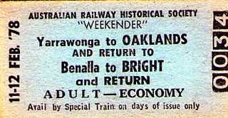
The Oaklands railway line is a freight-only railway line in north-eastern Victoria, Australia. The line branches from the main North East railway at Benalla station and runs across the Victoria-New South Wales border to the town of Oaklands, New South Wales.

The Mulwala Canal is an irrigation canal in the southern Riverina region of New South Wales, Australia. It is the largest irrigation canal in the Southern Hemisphere. The canal, starting at Lake Mulwala, diverts water from the Murray River across the southern Riverina plain to the Edward River at Deniliquin. The canal is 156 km long. The channel has an offtake capacity of 10,000 megalitres (ML) per day and annually supplies over 1,000,000 ML to 700,000 hectares in the Murray Irrigation Area.

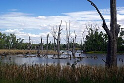
The Barmah National Park, formerly Barmah State Park, is a national park located in the Hume region of the Australian state of Victoria. The park is located adjacent to the Murray River near the town of Barmah, approximately 225 kilometres (140 mi) north of Melbourne. The park consists of river red gum floodplain forest, interspersed with treeless freshwater marshes. The area is subject to seasonal flooding from natural and irrigation water flows.

The Mulwala Bridge is a road bridge over Lake Mulwala, formed by a weir on the Murray River, on the state border between New South Wales and Victoria in Australia. The bridge links the border towns of Yarrawonga in Victoria and Mulwala in New South Wales. The bridge was built in 1924 and designed by Percy Allan using a Pratt truss.

The Menindee Lakes is a system of 9 large, but relatively shallow lakes, located in south-west New South Wales on the Darling (Barka) River, about 200 km upstream of the Darling River's junction with the River Murray. The Darling River is fed by nine major tributary river systems flowing from south-east Queensland and north and central NSW. The town of Menindee is close to the lakes and the nearest city is Broken Hill.

The Bethanga Bridge is a steel truss road bridge that carries the Riverina Highway across Lake Hume, an artificial lake on the Murray River in Australia. The dual heritage-listed bridge crosses the border between the Australian states of New South Wales and Victoria, linking the Victorian towns of Bellbridge and Bethanga with the regional New South Wales city of Albury.

Old Cobram-Barooga Bridge is a heritage-listed former road bridge and now footbridge over the Murray River at Barooga-Cobram Road, Barooga, New South Wales, Australia. The bridge links Barooga with Cobram, its sister town in Victoria. It was designed by Ernest de Burgh (engineer) and the New South Wales Department of Public Works and built from 1900 to 1902. It is also known as RMS Bridge No 3247. It is owned by Transport for NSW. It was added to the New South Wales State Heritage Register on 1 April 2016.
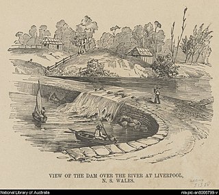
Liverpool Weir is a heritage-listed weir on the Georges River at Heathcote Road near Newbridge Road, Liverpool, Sydney, New South Wales, Australia. It was designed by David Lennox and built from 1836 by convict labour, directed by Captain W. H. Christie. It is also known as Bourke's Dam. It was added to the New South Wales State Heritage Register on 13 August 2010.