
The Murray River is a river in Southeastern Australia. It is Australia's longest river at 2,508 km (1,558 mi) extent. Its tributaries include five of the next six longest rivers of Australia. Together with that of the Murray, the catchments of these rivers form the Murray–Darling basin, which covers about one-seventh the area of Australia. It is widely considered Australia's most important irrigated region.

Victoria Island is a large island in the Arctic Archipelago that straddles the boundary between Nunavut and the Northwest Territories of Canada. It is the eighth-largest island in the world, and at 217,291 km2 (83,897 sq mi) in area, it is Canada's second-largest island. It is nearly double the size of Newfoundland (111,390 km2 [43,010 sq mi]), and is slightly larger than the island of Great Britain (209,331 km2 [80,823 sq mi]) but smaller than Honshu (225,800 km2 [87,200 sq mi]). The western third of the island lies in the Inuvik Region of the Northwest Territories; the remainder is part of Nunavut's Kitikmeot Region. The population of 2,168 is divided among 2 settlements, the larger of which is in Nunavut and the other of which is in the Northwest Territories.

Lake Victoria is one of the African Great Lakes. With a surface area of approximately 59,947 km2 (23,146 sq mi), Lake Victoria is Africa's largest lake by area, the world's largest tropical lake, and the world's second-largest fresh water lake by surface area after Lake Superior in North America. In terms of volume, Lake Victoria is the world's ninth-largest continental lake, containing about 2,424 km3 (1.965×10⁹ acre⋅ft) of water. Lake Victoria occupies a shallow depression in Africa. The lake has an average depth of 40 m (130 ft) and a maximum depth of 80–81 m (262–266 ft). Its catchment area covers 169,858 km2 (65,583 sq mi). The lake has a shoreline of 7,142 km (4,438 mi) when digitized at the 1:25,000 level, with islands constituting 3.7% of this length.
Victoria is the smallest mainland state in Australia. As of 2022 it contained 5,081 separate protected areas with a total land area of 4,012,888 ha.

The Lake Eildon National Park is a national park in the Central Highlands region of Victoria, Australia. The 27,750-hectare (68,600-acre) national park is set in the northern foothills of the Central Highlands, approximately 111 kilometres (69 mi) northeast of Melbourne and abuts the shores of Lake Eildon.
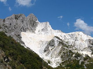
A quarry is a type of open-pit mine in which dimension stone, rock, construction aggregate, riprap, sand, gravel, or slate is excavated from the ground. The operation of quarries is regulated in some jurisdictions to manage their safety risks and reduce their environmental impact.

Kalamalka Lake is a large lake in the interior plateau of southern central British Columbia, Canada, east of Okanagan Lake. The lake is located approximately 4 kilometres (2.5 mi) south of the city of Vernon and is its main drinking water supply. The lake is named after the Okanagan First Nation chief who occupied its northern shores.

The Avoca River, an inland intermittent river of the north–central catchment, part of the Murray-Darling basin, is located in the lower Riverina bioregion and Central Highlands and Wimmera regions of the Australian state of Victoria. The headwaters of the Avoca River rise on the northern slopes of the Pyrenees Range and descend to flow into the ephemeral Kerang Lakes.

The Kagera River, also known as Akagera River, or Alexandra Nile, is an East African river, forming part of the upper headwaters of the Nile and carrying water from its most distant source. With a total length of 597 km (371 mi) from its source located in Lake Rweru in Rwanda.
Lake Corangamite, a hypersaline endorheic lake, is located near Colac in the Lakes and Craters region of the Victorian Volcanic Plains of south-west Victoria, Australia. The lake's salinity levels have increased dramatically as the lake level has dropped in recent decades. It is Australia's largest permanent saline lake, covering approximately 230 square kilometres (89 sq mi) with a circumference of 150 kilometres (93 mi). It forms part of the Ramsar-listed Western District Lakes wetland site. The Aboriginal name of the lake is recorded as Kronimite.

Uvs Lake is a highly saline lake in an endorheic basin—Uvs Nuur Basin, primarily in Mongolia with a smaller part in Russia. It is the largest lake in Mongolia by surface area, covering 3,350 km2 at 759 m above sea level. The northeastern tip of the lake is situated in the Tuva Republic of the Russian Federation. The largest settlement near the lake is Ulaangom. This shallow and very saline body of water is a remainder of a huge saline sea which covered a much larger area several thousand years ago.

Lake Colac, a freshwater lake of the Western District Lakes, is located north of the Colac town centre in Victoria, Australia. The Aboriginal name for the lake is cited in a colonial report as Coram.

The Thomson River, a perennial river of the West Gippsland catchment, is located in the Gippsland region of the Australian state of Victoria.
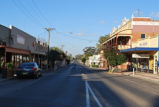
Sea Lake is a town in the Mallee district of north-west Victoria, Australia and is situated on the southern shores of Lake Tyrrell. The town is located on the Calder Highway, 351 kilometres (218 mi) north-west of Melbourne, and 73 kilometres (45 mi) west of Swan Hill. Sea Lake is in the heart of Australia's wheat belt, and is the main township for a number of wheat farms in the region. At the 2021 census, Sea Lake had a population of 619.

The Elk/Beaver Regional Park is a 1,072-acre (434 ha) park in Saanich, British Columbia, containing Elk Lake and Beaver Lake.
The Fred Haigh Dam is a dam in the Bundaberg Region, Queensland, Australia. It was constructed across the Kolan River in 1978 creating Lake Monduran. The dam's catchment area, north of Bundaberg in Queensland, covers 1308 km2. It is named after Frederick Haigh who was Queensland's Commissioner of Irrigation and Water Supply from 1955 to 1974. The Monduran Dam, under construction at the time of his death, was named after him upon completion.

Reedy Lake, historically also known as Lake Reedy, is a shallow 5.5-square-kilometre (2.1 sq mi) intermittent freshwater lake or swamp on the lower reaches of the Barwon River, on the Bellarine Peninsula southeast of Geelong in the Australian state of Victoria.
Lake Hindmarsh, an ephemeral lake located in the Wimmera region of western Victoria, Australia, is the state's largest natural freshwater lake. The nearest towns are Jeparit to the south and Rainbow to the north. After more than a decade of drought, in early 2011 the lake filled as a result of flooding in the region. The Wemba Wemba name of the lake is recorded as Gour or Koor.
Big Lake is a residential area in the northwest portion of the City of Edmonton in Alberta, Canada. It was established in 1991 through Edmonton City Council's adoption of the Big Lake Area Structure Plan, which guides the overall development of the area.
