Steavenson River

Last updated

Steavenson
Steavensons, Stevenson [1]
Steavenson Falls 10 January 1999.jpg
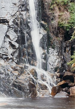
One of the five drops of the Steavenson Falls situated on the Steavenson River
Australia Victoria relief location map.jpg
Red pog.svg
Location of the Steavenson River mouth in Victoria
Native nameNur-ro-nur-ro (disputed) [2]
Location
Country Australia
State Victoria
Region South Eastern Highlands bioregion (IBRA), Northern Country/North Central
Local government area Murrindindi
Towns Marysville, Buxton
Physical characteristics
Source Yarra Ranges, Great Dividing Range
  locationbelow Mount Edgar
  coordinates 37°32′40″S145°47′10″E / 37.54444°S 145.78611°E / -37.54444; 145.78611
  elevation813 m (2,667 ft)
Mouth confluence with the Acheron River
  location
near Buxton
  coordinates
37°24′58″S145°41′55″E / 37.41611°S 145.69861°E / -37.41611; 145.69861 Coordinates: 37°24′58″S145°41′55″E / 37.41611°S 145.69861°E / -37.41611; 145.69861
  elevation
264 m (866 ft)
Length20 km (12 mi)
Basin features
River system Goulburn Broken catchment,
Murray-Darling basin
Tributaries 
  leftWilks Creek
  right Taggerty River, Keppel Creek
National park Yarra Ranges National Park
[3]

The Steavenson River, sometimes incorrectly referred to as Steavensons River, a minor inland perennial river of the Goulburn Broken catchment, part of the Murray-Darling basin, is located in the lower South Eastern Highlands bioregion and Northern Country/North Central regions of the Australian state of Victoria. The headwaters of the Steavenson River rise on the northwestern slopes of the Yarra Ranges, below Mount Edgar and descend to flow into the Acheron River near Buxton.

Contents

Location and features

The river rises below Mount Edgar on the northwestern slopes of the Yarra Ranges, part of the Great Dividing Range, within the Yarra Ranges National Park. The flows generally north by west, through rugged national park as the river descends, then north, joined by three tributaries including the Taggerty River, before reaching its confluence with the Acheron River near the settlement of Buxton. The river descends 549 metres (1,801 ft) over its 20-kilometre (12 mi) course. [3]

The river is crossed by the Maroondah Highway south of Buxton. An anabranch of the river, called Little Steavenson River, splits from the main river and reaches its confluence with the Acheron River, also near the settlement of Buxton. [3]

Steavenson Falls, a 122-metre (400 ft) horsetail waterfall located in the upper reaches of the river, descends over five drops, the last having a clear drop of more than 21 metres (69 ft) [4] and is situated approximately 3.4 kilometres (2.1 mi) east of Marysville. [5]

Much of the catchment area of the river was destroyed by the Black Saturday bushfires that passed through the area on 7 February 2009, destroying almost all of the man made infrastructure and causing extensive damage to the forest in the area. [6] [7]

Etymology

In an Australian Aboriginal language, the river is claimed to be named Nur-ro-nur-ro, with no defined meaning for the name. That claim is disputed. [2]

It is believed that the lower reaches of the Steavenson River, from the confluence of the Taggerty River with the Steavenson River, at the locale of Vic Oak, until the river mouth near Buxton, may have been initially named as the Taggerty River, until the Steavenson was officially named. [8]

See also

Related Research Articles

The Bunyip River is a perennial river of the Western Port catchment, located in the West Gippsland region of the Australian state of Victoria.

<span class="mw-page-title-main">Latrobe River</span> River in Victoria, Australia

The Latrobe River is a perennial river of the West Gippsland catchment, located in the West Gippsland region of the Australian state of Victoria. The Latrobe River and its associated sub-catchment is an important source for the Gippsland Lakes, draining the south eastern slopes of the Great Dividing Range.

The Rubicon River, an inland perennial river of the Goulburn Broken catchment, part of the Murray-Darling basin, is located in the lower South Eastern Highlands bioregion and Northern Country/North Central regions of the Australian state of Victoria. The headwaters of the Rubicon River rise on the western slopes of the Victorian Alps and descend to flow into the Goulburn River.

<span class="mw-page-title-main">Plenty River (Victoria)</span> River in Victoria, Australia

The Plenty River is a perennial river of the Port Phillip catchment, located in the north-eastern Greater Melbourne region of the Australian state of Victoria.

<span class="mw-page-title-main">Steavenson Falls</span> Waterfall in Australia

Steavenson Falls, a waterfall on the Steavenson River, is located 4 kilometres (2.5 mi) southeast of Marysville, Victoria, Australia. The falls are one of the tallest in Victoria, with five cascades, a total descent of 122 metres (400 ft), the last having a clear drop of more than 21 metres (69 ft).

<span class="mw-page-title-main">Barham River</span> Perennial river in Victoria, Australia

The Barham River is a perennial river of the Corangamite catchment, located in the Otways region of the Australian state of Victoria.

<span class="mw-page-title-main">O'Shannassy River</span> River in Victoria, Australia

The O'Shannassy River is a perennial river of the Port Phillip catchment, located in the north-eastern Greater Metropolitan Melbourne region of the Australian state of Victoria.

<span class="mw-page-title-main">Little Yarra River</span> River in Victoria, Australia

The Little Yarra River is a perennial river of the Port Phillip catchment, located in the Greater Metropolitan Melbourne region of the Australian state of Victoria.

The Watts River is a perennial river of the Port Phillip and Western Port catchment, located in the Healesville area, in the Central region of the Australian state of Victoria.

The Tarwin River is a perennial river of the West Gippsland catchment, located in the South Gippsland region of the Australian state of Victoria. The Tarwin River is the primary river system within South Gippsland Shire and has a catchment area of approximately 1,500 square kilometres (580 sq mi), predominantly rural with small pockets of residential land use. It flows south from the Strzlecki Ranges and discharges in the eastern reaches of Anderson Inlet, a shallow estuary connected to Bass Strait.

The Acheron River, a minor inland perennial river of the Goulburn Broken catchment, part of the Murray-Darling basin, is located in the lower South Eastern Highlands bioregion and Northern Country/North Central regions of the Australian state of Victoria. The headwaters of the Acheron River rise on the north–western slopes of the Yarra Ranges, below The Knobs and descend to flow into the Goulburn River near Alexandra.

<span class="mw-page-title-main">Moroka River</span> River in Victoria, Australia

The Moroka River is a perennial river of the Mitchell River catchment, located in the Alpine region of the Australian state of Victoria.

The Ada River is a perennial river of the West Gippsland catchment, located in the West Gippsland region of the Australian state of Victoria.

The Toorongo River is a perennial river of the West Gippsland catchment, located in the West Gippsland region of the Australian state of Victoria.

The Tarago River is a perennial river of the Western Port catchment, located in the West Gippsland region of the Australian state of Victoria.

<span class="mw-page-title-main">Dandongadale River</span> River in Victoria, Australia

The Dandongadale River, a perennial river of the North-East Murray catchment of the Murray-Darling basin, is located in the Alpine region of Victoria, Australia. It flows from the northern slopes of the Alpine National Park in the Australian Alps, joining with the Buffalo River in remote national park territory.

The Little River, a minor inland perennial river of the Goulburn Broken catchment, part of the Murray-Darling basin, is located in the lower South Eastern Highlands bioregion and Northern Country/North Central regions of the Australian state of Victoria. The headwaters of the Little River rise below the Cathedral Range and descend to flow into the Acheron River at Taggerty.

The Taggerty River, a minor inland perennial river of the Goulburn Broken catchment, part of the Murray-Darling basin, is located in the lower South Eastern Highlands bioregion and Northern Country/North Central regions of the Australian state of Victoria. The headwaters of the Taggerty River rise on the north–western slopes of the Yarra Ranges, below Lake Mountain and descend to flow into the Steavenson River near Marysville.

<span class="mw-page-title-main">Big River (Goulburn River, Victoria)</span> River in Victoria, Australia

The Big River, an inland perennial river of the Goulburn Broken catchment, part of the Murray-Darling basin, is located in the lower South Eastern Highlands bioregion and Northern Country/North Central regions of the Australian state of Victoria. The headwaters of the Big River rise on the northern slopes of the Yarra Ranges and descend to flow into the Goulburn River within Lake Eildon.

The Black River, an inland perennial river of the Goulburn Broken catchment, part of the Murray-Darling basin, is located in the lower South Eastern Highlands bioregion and Northern Country/North Central regions of the Australian state of Victoria. The headwaters of the Black River rise on the northern slopes of the Yarra Ranges and descend to flow into the Goulburn River within the Yarra Ranges National Park.

References

  1. "Steavenson River: 26321". Vicnames. 2 May 1966. Archived from the original on 8 August 2014. Retrieved 8 August 2014.
  2. 1 2 "Steavenson River: 2467: Historical Information". 12 August 2011. Archived from the original on 8 August 2014. Retrieved 8 August 2014.
  3. 1 2 3 "Map of Steavenson River, VIC". Bonzle Digital Atlas of Australia. Retrieved 8 August 2014.
  4. "Steavenson Falls – Marysville". Yarra Valley Booking Service.
  5. "Map of Steavenson Falls, VIC". Bonzle Digital Atlas of Australia. Retrieved 8 August 2014.
  6. "DELWP". 10 November 2020.
  7. "DELWP". 10 November 2020.
  8. "Taggerty River: Historical information: 2503". Vicnames. 12 August 2011. Archived from the original on 8 August 2014. Retrieved 8 August 2014.