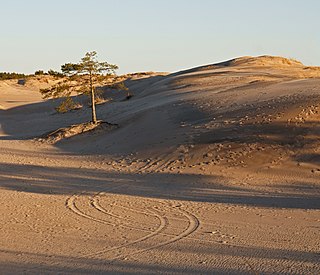
A dune is a landform composed of wind- or water-driven sand. It typically takes the form of a mound, ridge, or hill. An area with dunes is called a dune system or a dune complex. A large dune complex is called a dune field, while broad, flat regions covered with wind-swept sand or dunes with little or no vegetation are called ergs or sand seas. Dunes occur in different shapes and sizes, but most kinds of dunes are longer on the stoss (upflow) side, where the sand is pushed up the dune, and have a shorter slip face in the lee side. The valley or trough between dunes is called a dune slack.

Lake Michigan is one of the five Great Lakes of North America. It is the second-largest of the Great Lakes by volume and the third-largest by surface area, after Lake Superior and Lake Huron. To the east, its basin is conjoined with that of Lake Huron through the 3+1⁄2 miles wide, 295 feet deep, Straits of Mackinac, giving it the same surface elevation as its easterly counterpart; the two are technically a single lake.
The Croajingolong National Park is a coastal national park located in the East Gippsland region of the Australian state of Victoria. The 88,355-hectare (218,330-acre) national park is situated approximately 450 kilometres (280 mi) east of Melbourne and 500 kilometres (310 mi) south of Sydney.

Port Phillip or Port Phillip Bay is a horsehead-shaped enclosed bay on the central coast of southern Victoria, Australia. The bay opens into the Bass Strait via a short, narrow channel known as The Rip, and is completely surrounded by localities of Victoria's two largest cities — metropolitan Greater Melbourne in the bay's main eastern portion north of the Mornington Peninsula, and the city of Greater Geelong in the much smaller western portion north of the Bellarine Peninsula. Geographically, the bay covers 1,930 km2 (750 sq mi) and the shore stretches roughly 264 km (164 mi), with the volume of water around 25 km3 (6.0 cu mi). Most of the bay is navigable, although it is extremely shallow for its size — the deepest portion is only 24 m (79 ft) and half the bay is shallower than 8 m (26 ft). Its waters and coast are home to seals, whales, dolphins, corals and many kinds of seabirds and migratory waders.
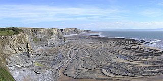
A wave-cut platform, shore platform, coastal bench, or wave-cut cliff is the narrow flat area often found at the base of a sea cliff or along the shoreline of a lake, bay, or sea that was created by erosion. Wave-cut platforms are often most obvious at low tide when they become visible as huge areas of flat rock. Sometimes the landward side of the platform is covered by sand, forming the beach, and then the platform can only be identified at low tides or when storms move the sand.

Indiana Dunes National Park is a United States national park located in northwestern Indiana managed by the National Park Service. It was authorized by Congress in 1966 as the Indiana Dunes National Lakeshore and was redesignated as the nation's 61st national park on February 15, 2019. The park runs for about 20 miles (32 km) along the southern shore of Lake Michigan and covers 15,349 acres (6,212 ha). Along the lakefront, the eastern area is roughly the lake shore south to U.S. 12 or U.S. 20 between Michigan City, Indiana, on the east and the Cleveland-Cliffs steel plant on the west. A small extension south of the steel mill continues west along Salt Creek to Indiana 249. The western area is roughly the shoreline south to U.S. 12 between the Burns Ditch west to Broadway in downtown Gary, Indiana. In addition, there are several outlying areas, including Pinhook Bog, in LaPorte County to the east; the Heron Rookery in Porter County, the center of the park; and the Calumet Prairie State Nature Preserve and the Hobart Prairie Grove, both in Lake County, the western end of the park.

Southwick Beach State Park is a New York State park that lies along an unusual stretch of sandy beach on the eastern shore of Lake Ontario. The park is 464 acres (188 ha) in size with a 3,500 foot (1,100 m) length of beach, and is visited annually by about 100,000 people. Immediately to the south is the Lakeview Wildlife Management Area, which extends the publicly accessible beach by several miles. They are in the Town of Ellisburg in Jefferson County, New York south of the lakeside community of Jefferson Park.
Indiana Dunes State Park is an Indiana State Park located in Porter County, Indiana, United States, 47 miles (75.6 km) east of Chicago. The park is bounded by Lake Michigan to the northwest and is surrounded by as well as within the authorized boundaries of Indiana Dunes National Park, a unit of the National Park Service; the NPS owns the water from the ordinary high water mark to 300 feet (91 m) offshore. The 1,530-acre (619.2 ha) Dunes Nature Preserve makes up the bulk of eastern part of the park, and includes most of the park's hiking trails and dune landscape. This was one of the first places Richard Lieber considered when establishing the Indiana State Park system. Like all Indiana state parks, there is a fee for entrance. Indiana Dunes State Park was established in 1925 and designated a National Natural Landmark in 1974.

"Victoria (Australia)" is an invalid category parameter for Template:Coord missing.
The problem is usually caused either by a spelling mistake or by an-over-precise category.
For a full list of categories, see Category:Unclassified articles missing geocoordinate data and its subcategories.
Northwest Indiana, nicknamed The Region after the Calumet Region, comprises Lake, Porter, LaPorte, and Newton counties in Indiana. This region neighbors Lake Michigan and is part of the Chicago metropolitan area. According to the 2020 Census, Northwest Indiana has a population of 831,080 and is the state's second largest urban area after the Indianapolis Metropolitan Area. It is also the home of the Indiana Dunes, parts of which have been preserved through conservation efforts. The town of Ogden Dunes houses the Hour Glass, a museum showcasing the ecological and conservation efforts of O. D. Frank.

Sandy Island Beach State Park is a New York State park on the eastern shore of Lake Ontario. Its highlight is a 1,500-foot (460 m) natural sandy beach. The park is near the southern end of a notable 17-mile (27 km) length of sandy shoreline, coastal dunes, and wetlands ; a 1959 study noted that "The eastern end of Lake Ontario contains not only the finest beaches on the entire lake but also the finest wildlife habitat."

Bemm River is a township and locality in the East Gippsland region of Victoria, Australia. At the 2016 census, Bemm River and the surrounding area had a population of 60.

Whitefish Dunes State Park is a 867-acre (351 ha) state park of Wisconsin on the eastern shore of the Door Peninsula. This day-use park preserves the most substantial sand dunes on the western shore of Lake Michigan. The remains of eight successive prehistoric Native American villages are on the National Register of Historic Places as Whitefish Dunes-Bay View Site. Cave Point County Park is an enclave inside the state park, allowing visitors free foot access to the state park by the shoreline trail connecting the parks.
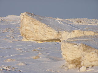
Shelf ice is ice that forms when a portion of a lake surface freezes. It is often then washed upon the shore. The phenomenon is common within the Great Lakes.

Cuspate forelands, also known as cuspate barriers or nesses in Britain, are geographical features found on coastlines and lakeshores that are created primarily by longshore drift. Formed by accretion and progradation of sand and shingle, they extend outwards from the shoreline in a triangular shape.
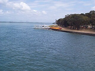
Pumicestone Channel, also known as the Pumicestone Passage, is a narrow waterway between Bribie Island and the mainland in Queensland, Australia. The northern extent of the passage is at Caloundra, while at the south is Deception Bay. The waterway is a two way tidal estuary that has 11 creeks flowing into it. At each end of the passage the channels are the deepest and widest.

Black Pond Wildlife Management Area is a 526-acre (213 ha) New York State Wildlife Management Area (WMA) that lies on the eastern shore of Lake Ontario, and at the northern limit of an unusual region of sandy barrier beaches and lagoons. Much of the barrier beach in Black Pond WMA has forested sand dunes that are about 60 feet (18 m) high; these are the highest sand dunes in the northeast United States excepting Cape Cod. Immediately north of the WMA is the 360-acre (150 ha) El Dorado Beach Preserve, which is a bird refuge owned by The Nature Conservancy. North of the outlet from Black Pond to Lake Ontario, the shoreline is a weathered, flat bedrock shelf that is "calcareous" instead of sandy.

The Indiana Dunes comprise ten different habitats. Each provides for a unique combination of plants and animals. The range of the Indiana Dunes varies depending your source. The Indiana Lake Michigan Coastal Program uses the river drainage systems along the shoreline. This expands the area from the areas of lakeshore southward to the edges of the Valparaiso Moraine. This entire region has been dune landscapes since over 114,000 years before present (YBP). Traditionally, the Indiana Dunes area thought of as a narrow area along the shores of Lake Michigan, including the areas of Marquette Park in Gary, Indiana (1920), Indiana Dunes State Park (1926) and Indiana Dunes National Park,. The identified ten habitats can be found in these parks, where they have been preserved, but are also visible throughout the three counties of Northwest Indiana.
The Toleston Shoreline is the third ancient shoreline of the precursor to Lake Michigan, Lake Chicago. It takes its name from the village of Tolleston, now a portion of Gary, Indiana. The shoreline formed when Lake Chicago was high enough to drain through the Chicago outlet into the Des Plaines River. The beach is 18 to 25 feet above the level of Lake Michigan. The Indiana segment and the Illinois segment, north to Evanston are still visible. North of Evanston and Michigan City, Indiana, the beach has been eroded by later ice movement or shoreline wave action.

Ship Creek is a small river that flows into an area of coastal swamp forest on the West Coast of New Zealand's South Island. Ship Creek is approximately 11 km (6.8 mi) long and flows northwest from catchment areas on the slopes of Bald Hill, reaching the Tasman Sea around 20 km (12 mi) north-east of Haast. Near the mouth of Ship Creek, there are short walks around dune lakes and ancient kahikatea swamp forest.

