Crater Lake is a volcanic crater lake in south-central Oregon in the Western United States. It is the main feature of Crater Lake National Park and is famous for its deep blue color and water clarity. The lake partly fills a 2,148-foot-deep (655 m) caldera that was formed around 7,700 years ago by the collapse of the volcano Mount Mazama. No rivers flow into or out of the lake; the evaporation is compensated for by rain and snowfall at a rate such that the total amount of water is replaced every 250 years. With a depth of 1,949 feet (594 m), the lake is the deepest in the United States. In the world, it ranks tenth for maximum depth, as well as third for mean (average) depth.

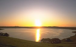
Lake Taupō is a large crater lake in New Zealand's North Island, located in the caldera of Taupō Volcano. The lake is the namesake of the town of Taupō, which sits on a bay in the lake's northeastern shore. With a surface area of 616 km2 (238 sq mi), it is the largest lake by surface area in New Zealand, and the second largest freshwater lake by surface area in geopolitical Oceania after Lake Murray in Papua New Guinea. Motutaiko Island lies in the southeastern area of the lake.

Whakaari / White Island, also known as White Island or Whakaari, is an active andesite stratovolcano situated 48 km (30 mi) from the east coast of the North Island of New Zealand, in the Bay of Plenty. The island covers an area of approximately 325 ha, which is just the peak of a much larger submarine volcano.

The Marrah Mountains or Marra Mountains are a range of volcanic peaks in a massif that rises up to 3,042 metres (9,980 ft). They are the highest mountains in Sudan.

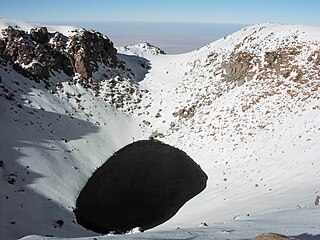
The Pingualuit Crater, formerly called the "Chubb Crater" and later the "New Quebec Crater", is a relatively young impact crater located on the Ungava Peninsula in the administrative region of Nord-du-Québec, in Quebec, Canada. It is 3.44 km (2.14 mi) in diameter, and is estimated to be 1.4 ± 0.1 million years old (Pleistocene). The crater and the surrounding area are now part of Pingualuit National Park. The only species of fish in the crater lake is the Arctic char.

Blue Lake / Warwar is a large, monomictic, crater lake located in a dormant volcanic maar associated with the Mount Gambier maar complex. The lake is situated near Mount Gambier in the Limestone Coast region of South Australia, and is one of four volcanic crater lakes originally on Mount Gambier maar. Of the four lakes, only two remain, the other one being Valley Lake / Ketla Malpi; the other two, Leg of Mutton Lake / Yatton Loo and Brownes Lake / Kroweratwari, dried up as the water table dropped.

Lake Voulismeni is a small, formerly freshwater lake, later connected to the sea, located at the centre of the town of Agios Nikolaos on the Greek island of Crete. It has a circular shape with a diameter of 137 m and a depth of 48.8 m. The locals refer to it as simply "The Lake". The lake is connected to the harbour of the town by a channel dug by soldiers of the French Army in 1907. A panoramic view of the lake can be seen from a small park situated above it.

Lake Assal is a crater lake in central-western Djibouti. It is located at the western end of Gulf of Tadjoura between Arta Region, and Tadjoura Region, touching Dikhil Region, at the top of the Great Rift Valley, some 120 km (75 mi) west of Djibouti city. Lake Assal is a saline lake that lies 155 m (509 ft) below sea level in the Afar Triangle, making it the lowest point on land in Africa and the third-lowest point on Earth after the Sea of Galilee and the Dead Sea. No outflow occurs from the lake, and due to high evaporation, the salinity level of its waters is 10 times that of the sea, making it the fifth most saline body of water in the world, behind Garabogazköl, Lake Retba, and Gaet'ale Pond. The salt in the lake is exploited under four concessions awarded in 2002 at the southeast end of the lake; the major share of production is held by Société d’Exploitation du Lac and Société d’Exploitation du Salt Investment S.A de Djibouti.
Lake Purrumbete is a volcanic lake located in the Western District of Victoria, Australia. Lake Purrumbete is approximately 15 km (9.3 mi) east of the town of Camperdown. The lake is in a shallow maar. The water is crystal clear most times of the year as the lake relies totally on its own catchment.

Camperdown is a town in southwestern Victoria, Australia, 190 kilometres (120 mi) west of the state capital, Melbourne. At the 2016 census, Camperdown had a population of 3,369.
Lake Logipi is a saline, alkaline lake that lies at the northern end of the arid Suguta Valley in the northern Kenya Rift. It is separated from Lake Turkana by the Barrier volcanic complex, a group of young volcanoes that last erupted during the late 19th century or early 20th century. Saline hot springs discharge on the northern shoreline of Lake Logipi and at Cathedral Rocks near its southern limit, and help to maintain water at times of extreme aridity. During the rainy season, the lake is also recharged from the Suguta River which flows northward along the Suguta Valley, periodically forming a temporary lake that unites with Logipi.
Tower Hill is an inactive volcano on the south-west coast of Victoria, Australia, approximately 275 kilometres (171 mi) west of Melbourne, and 15 kilometres (9 mi) north-west of Warrnambool. The Tower Hill crater is roughly 3 kilometres (2 mi) wide and 80 metres (260 ft) high, with a gradient of between 10% and 80% at the higher points. Within the crater, a series of later volcanic explosions formed a number of scoria cones and spheres, surrounded by a crater lake. Being a giant nested maar, Tower Hill is of international geological significance. The Dhauwurdwurrung name for the volcano is Koroitj.

Nemrut is a dormant volcano in Tatvan district, Bitlis province, Eastern Turkey, close to Lake Van. The volcano is named after King Nimrod who is said to have ruled this area in about 2100 BC.

The Soda Lakes are two lakes located northwest of Fallon, Nevada. They occupy two basaltic maar volcano craters which may have erupted in the last 1500 years. The larger lake, called Soda Lake or Big Soda Lake, is somewhat elongated, stretching 2 kilometers (1.2 mi) in length. The smaller one, Little Soda Lake, is 200 meters (660 ft) across. Considered to be a single volcano, the combined craters are young enough that future activity can't be ruled out. A geothermal power plant is located on the northeast flank of the volcano.

Halemaʻumaʻu is a pit crater within the much larger Kīlauea Caldera at the summit of Kīlauea volcano on island of Hawaiʻi. The roughly circular crater was 770 meters (2,530 ft) x 900 m (2,950 ft) before collapses that roughly doubled the size of the crater after May 3, 2018. Following the collapses of 2018, the bottom of Halemaʻumaʻu was roughly 600 m (2,000 ft) below the caldera floor. Halemaʻumaʻu is home to Pele, goddess of fire and volcanoes, according to the traditions of Hawaiian religion. Halemaʻumaʻu means "house of the ʻāmaʻu fern".
Mount Leura is a 313-metre scoria cone surrounding a dry crater 100 m deep and is the central and most obvious component of a larger volcanic complex southeast of the town of Camperdown located in western Victoria, Australia, 194 kilometres (121 mi) south west of the state capital, Melbourne. The inactive volcano is thought to have last erupted between 5,000 and 20,000 years ago. The name means "big nose" in the local Aboriginal dialect.
Licancabur Lake is a crater lake in Chile located on the volcano Licancabur. It is close to the city San Pedro de Atacama and also very close to the border of Chile with Bolivia.

Lake Pinatubo is the summit crater lake of Mount Pinatubo formed after its climactic eruption on June 15, 1991. The lake is located in Botolan, Zambales, near the boundaries of Pampanga and Tarlac provinces in the Philippines. It is about 90 km (56 mi) northwest of the capital city of Manila. While one paper by researchers from Japan suggested a depth of 600 m (2,000 ft), more detailed research suggests that 95–115 m (312–377 ft) is more accurate.
Lake Meke is a volcanic crater lake composed of two nested lakes located in Konya Province, central Turkey. It is a registered natural monument of the country and a Ramsar site. Lake Meke is located in Karapınar district of Konya Province. It is 9 km (5.6 mi) away from Karapınar, and 2 km (1.2 mi) south of the Konya-Adana highway E981.

A volcanic crater lake is a lake in a crater that was formed by explosive activity or a collapse during a volcanic eruption.