
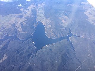
Dartmouth Dam is a large rock-fill embankment dam with an uncontrolled chute spillway across the Mitta Mitta, Gibbo and Dart rivers, the Morass Creek and a number of small tributaries. The dam is located near Mount Bogong in the north-east of the Australian state of Victoria. The dam's purpose includes irrigation, the generation of hydro-electric power, water supply and conservation. The impounded reservoir is called Dartmouth Reservoir, sometimes called Lake Dartmouth. The Dartmouth Power Station, a hydro-electric power station that generates power to the national grid, is located near the dam wall.

Hume Dam, formerly the Hume Weir, is a major dam across the Murray River downstream of its junction with the Mitta River in the Riverina region of New South Wales, Australia. The dam's purpose includes flood mitigation, hydro-power, irrigation, water supply and conservation. The impounded reservoir is called Lake Hume, formerly the Hume Reservoir. It is a gated concrete gravity dam with four earth embankments and twenty-nine vertical undershot gated concrete overflow spillways.

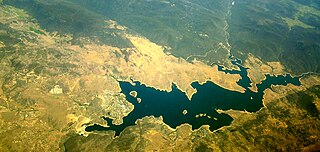
The Eildon Dam is a rock and earth-fill embankment dam with a controlled spillway, located on the Goulburn River between the regional towns of Mansfield and Eildon within Lake Eildon National Park, in the Alpine region of Victoria, Australia. The dam's purpose is for the supply of potable water, irrigation, and the generation of hydroelectricity. The impounded reservoir is called Lake Eildon.The first cut of ground was done by Mr Bain and Mr MacLean from Scotland.

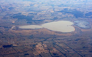
The Waranga Dam is a major earthfill embankment dam with an uncontrolled spillway located approximately 150 kilometres (93 mi) north of Melbourne in the North Central region of the Australian state of Victoria. The impounded off-stream reservoir is Waranga Basin and forms part of the Goulburn River irrigation system, irrigating an area of 626 square kilometres (242 sq mi). The dam and reservoir are located in Shire of Campaspe near the City of Greater Shepparton and is located 8 kilometres (5 mi) north-east of Rushworth, 12 kilometres (7.5 mi) south-west of Tatura, and near Murchison. When full, the reservoir covers an area of 58.5 square kilometres (22.6 sq mi).

The Loddon River, an inland river of the north–central catchment, part of the Murray-Darling basin, is located in the lower Riverina bioregion and Central Highlands and Loddon Mallee regions of the Australian state of Victoria. The headwaters of the Loddon River rise on the northern slopes of the Great Dividing Range east of Daylesford and descend to flow north into the Little Murray River, near Swan Hill. The river is impounded by the Cairn Curran and Laanecoorie reservoirs.

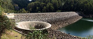
Lake Eppalock is an Australian reservoir in North Central Victoria about 130 kilometres (81 mi) northwest of Melbourne. It was formed by the construction of a major earth and rockfill embankment dam, known as Eppalock Dam, with a controlled chute spillway across the Campaspe and the Coliban rivers. The lake is situated between the regional population centres of Bendigo and Heathcote and serves as a major water storage facility for both places, as well as the Campaspe irrigation district. The lake also serves as a popular sports and recreational facility.
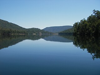
Burrinjuck Dam is a gated, concrete-walled hydro-electric gravity dam at Burrinjuck, in the South West Slopes region of New South Wales, Australia. It has three spillways across the Murrumbidgee River and forms an impounded reservoir called Lake Burrinjuck. In addition to electricity generation, Burrinjuck Dam is used for purposes including flood mitigation, irrigation, water supply and conservation. Also known as Barren Jack Dam and Barrenjack, it was added to the New South Wales State Heritage Register on 2 April 1999.
Jindabyne Dam is a major ungated rockfill embankment dam across the Snowy River in the Snowy Mountains of New South Wales, Australia. The dam's main purpose is to redirect water from the Snowy River to the Murray, for the generation of hydro-power and irrigation. It is one of the sixteen major dams that comprise the Snowy Mountains Scheme, a vast hydroelectricity and irrigation complex constructed in south-east Australia between 1949 and 1974 and now run by Snowy Hydro.
Lake Mokoan was an artificial lake in northern Victoria, Australia, roughly 7 km north-east of Benalla. It was created by diverting water from the Broken River and Hollands Creek into Winton and Green swamps. Construction began in the late 1960s and was completed in 1971.

The Rubicon Hydroelectric Scheme is a small run-of-the-river hydroelectric scheme located on the Rubicon and Royston Rivers, north east of Melbourne, 40 km (25 mi) south-west of Alexandra, Victoria, Australia. The scheme commenced in 1922, and was the first state-owned hydroelectric scheme to generate electricity in mainland Australia, and among the first in the world to be remotely controlled. For the first ten years of its operation it supplied on average 16.9% of electricity generated by the State Electricity Commission of Victoria. It is now owned and operated by AGL Energy and contributes approximately 0.02% of Victoria's energy supply.
The William Hovell Dam is a rock and earth-fill embankment dam with a flip bucket chute spillway across the King River, operated by Pacific Blue and located in the Hume region of Victoria, Australia. The purposes of the dam are for irrigation and the generation of hydroelectricity. The impounded reservoir is called Lake William Hovell.
Goulburn Weir is a weir built between 1887 and early 1891 across the Goulburn River near Nagambie, Victoria, Australia. It was the first major diversion structure built for irrigation development in Australia. The weir also forms Lake Nagambie where rowing regattas and waterskiing tournaments are held.

The Upper Yarra Reservoir is located east of Melbourne, Victoria, Australia, beyond Warburton within the locality of Reefton. Water from Upper Yarra Reservoir supplies towns in the upper Yarra Valley, and Silvan Reservoir, which transfers water to most parts of Melbourne.
Tahbilk Winery is a historic Australian winery with National Trust certification. It is located 120 km (75 mi) north of Melbourne between the townships of Seymour and Nagambie in the Nagambie Lakes a sub region of Goulburn Valley Wine Region. It was established in 1860, and is the oldest family-owned winery and vineyard in Victoria. In 2022 it was ranked the eighteenth largest Australian wine company by production, and the tenth largest in terms of total revenue. The winery is part of Australia's First Families of Wine, a prominent Australian wine alliance.
The North–South Pipeline, also known as the Sugarloaf Pipeline, is a water pipeline in Central Victoria, Australia, north-east of Melbourne that is part of Victoria's water system, acting as a link between Melbourne's water grid and the Murray-Goulburn water grid, supplying water via a series of existing and proposed pipelines. The 70-kilometre pipeline was connected to Melbourne in February 2010 to carry water from the Goulburn River to Melbourne's Sugarloaf Reservoir. It is the government's policy that it only be used in times of critical human need: when Melbourne's total water storages are less than 30% full on 30 November of any year. The pipeline can transfer a portion of Lake Eildon's water that is set aside for Melbourne, called the critical water reserve. This was 38,400 megalitres at 2 June 2014, and any changes are based on Goulburn-Murray Water's advice.
The O'Shannassy Reservoir is an Australian man-made water supply dammed reservoir. The 3.123 GL water store across the O'Shannassy River is located near the locality of McMahons Creek, approximately 80 kilometres (50 mi) east of Melbourne, Victoria. The dam that creates the impoundment is called the O'Shannassy Dam.
Toorourrong Reservoir is a small water supply reservoir located on the southern slopes of the Great Dividing Range approximately 40 kilometres (25 mi) north of Melbourne, Victoria, Australia. The reservoir is formed by the Toorourrong Dam across the Plenty River, and an interbasin transfer. The dam is operated by Melbourne Water and the reservoir forms part of the Melbourne water supply system. Water from the Toorourrong Reservoir flows by aqueduct to the Yan Yean Reservoir.

Laanecoorie Weir or Laanecoorie Reservoir, is a water storage for irrigation and domestic purposes on the Loddon River, near the towns of Laanecoorie, Victoria and Eddington, Victoria. It was constructed by contractor Andrew O'Keefe (engineer) in conjunction with Joshua Thomas Noble Anderson. This was the second irrigation scheme for Victoria after the Goulburn Weir. Construction commenced in 1889 and took three years to complete. The largest outlet valves in Victoria, manufactured by the United Iron Work of Abraham Roberts, were installed at the weir in 1891.
The Arthurs Lake is a man-made reservoir located in the Central Highlands region of Tasmania, Australia. The lake was created in the 1920s by the Hydro-Electric Commission of Tasmania damming the Upper Lake River, Blue Lake and Sand Lake as well as the Morass Marsh. The principal purpose of the lake is to support the generation of hydroelectricity.
Geehi Dam is a major ungated rockfill embankment dam across the Geehi River in the Snowy Mountains of New South Wales, Australia. The reservoir impounded by the dam is known as Geehi Reservoir.


