
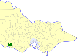
The Shire of Moyne is a local government area in the Barwon South West region of Victoria, Australia, located in the south-western part of the state. It covers an area of 5,481 square kilometres (2,116 sq mi) and in June 2018 had a population of 16,887. It includes the towns of Port Fairy, Koroit, Mortlake, Macarthur, Peterborough, Caramut, Ellerslie, Framlingham, Garvoc, Hawkesdale, Kirkstall, Panmure, Mailors Flat, Purnim, Wangoom and Woolsthorpe. It also entirely surrounds the City of Warrnambool, a separate local government area. It was formed in 1994 from the amalgamation of the Shire of Belfast, Shire of Minhamite, Borough of Port Fairy, and parts of the Shire of Mortlake, Shire of Warrnambool, Shire of Dundas, Shire of Mount Rouse and Shire of Hampden.

The Tweed River is a river situated in the Northern Rivers district of New South Wales, Australia. From the middle reaches of its course, the state boundary between New South Wales and Queensland is located approximately 10 kilometres (6.2 mi) north.

The Port River is part of a tidal estuary located north of the Adelaide city centre in the Australian state of South Australia. It has been used as a shipping channel since the beginning of European settlement of South Australia in 1836, when Colonel Light selected the site to use as a port. Before colonisation, the Port River region and the estuary area were known as Yerta Bulti by the Kaurna people, and used extensively as a source of food and plant materials to fashion artefacts used in daily life.

Port Fairy is a coastal town in south-western Victoria, Australia. It lies on the Princes Highway in the Shire of Moyne, 28 kilometres (17 mi) west of Warrnambool and 290 kilometres (180 mi) west of Melbourne, at the point where the Moyne River enters the Southern Ocean.

The Gold Coast Seaway or Southport Seaway is the main navigation entrance from the Pacific Ocean into the Gold Coast Broadwater and southern Moreton Bay and is one of Australia's most significant coastal engineering projects. It is located at the northern end of the Southport Spit where the Nerang River enters the Pacific Ocean. The channel was constructed between 1984 and 1986, primarily to facilitate the safe passage of sea-faring vessels. The passage was previously known as the Southport Bar. The mouth of the Nerang River was once located further south in Broadbeach. The main driving force for this movement is the northward drift of sand along the coast.

Allestree is a small town in Victoria, Australia. It is located along the Princes Highway, north-east of Portland. At the 2016 Census, Allestree and the surrounding area recorded a population of 128.

The Hopkins River, a perennial river of the Glenelg Hopkins catchment, is located in the Western District of Victoria, Australia.

The Glenelg River, a perennial river of the Glenelg Hopkins catchment, is located in the Australian states of Victoria and South Australia.

The Patawalonga River is a river located in the western suburbs of the Adelaide metropolitan area, in the Australian state of South Australia. It drains an area of flat, swampy lands formerly known as the Cowandilla Plains or The Reedbeds, which in the mid-20th century were drained by engineering works, enabling the establishment of Adelaide Airport and the development of residential housing.

The Shire of Belfast was a local government area about 290 kilometres (180 mi) west-southwest of Melbourne, the state capital of Victoria, Australia. The shire covered an area of 5,190 square kilometres (2,003.9 sq mi), and existed from 1853 until 1994.
The Shire of Minhamite was a local government area about 270 kilometres (168 mi) west of Melbourne, the state capital of Victoria, Australia. The shire covered an area of 1,365.62 square kilometres (527.3 sq mi), and existed from 1871 until 1994.

The Borough of Port Fairy was a local government area about 290 kilometres (180 mi) west-southwest of Melbourne, the state capital of Victoria, Australia. The borough covered an area of 22.72 square kilometres (8.8 sq mi), and existed from 1856 until 1994. Its area was surrounded by the Shire of Belfast and the Southern Ocean.

The Port Fairy - Warrnambool Rail Trail is a 37 kilometre rail trail in southwestern Victoria, Australia. The official opening of the trail took place on 31 May 2012 at the Koroit Railway station building.

Reedy Lake, historically also known as Lake Reedy, is a shallow 5.5-square-kilometre (2.1 sq mi) intermittent freshwater lake or swamp on the lower reaches of the Barwon River, on the Bellarine Peninsula southeast of Geelong in the Australian state of Victoria.
Hexham is a township in Victoria, Australia.
The Merri River, a perennial river of the Glenelg Hopkins catchment, is located in the Western District of Victoria, Australia.
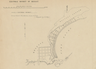
The electoral district of Belfast was an electorate of the Victorian Legislative Assembly in the British colony of Victoria. It was one of the original lower house seats in the first Parliament of Victoria in 1856. Belfast was renamed in 1889 to Port Fairy after the town of Belfast was also renamed.

Griffiths Island, sometimes incorrectly spelled as Griffith Island or Griffitts Island, lies at the mouth of the Moyne River next to, and within the bounds of, the town of Port Fairy, in the Western District of the state of Victoria in Australia. Griffiths now has no permanent inhabitants, but is connected to the mainland by a causeway and is accessible on foot. It forms part of the Port Fairy and Belfast Coastline Protection Reserve and, as well as being a tourist attraction, is an important site in the context of the history of European settlement of western Victoria. It is managed by the Moyne Shire Council.
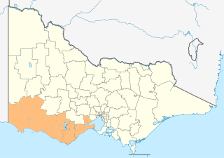
The Barwon South West is an economic rural region located in the southwestern part of Victoria, Australia. The Barwon South West region stretches from the tip of the Queenscliff Heads to the border of South Australia. It is home to Victoria’s largest provincial centre, Geelong and the major centres of Aireys Inlet, Apollo Bay, Camperdown, Colac, Hamilton, Lorne, Port Campbell, Port Fairy, Portland, Torquay and Warrnambool. It draws its name from the Barwon River and the geographic location of the region in the state of Victoria.
Belfast Coastal Reserve is a narrow belt of public land on the Shipwreck Coast about 300 kilometres south-west of Melbourne in the State of Victoria, Australia. Stretching 22 kilometres from Levys Point Reserve at Warrnambool in the east, to Belfast Lough at Port Fairy in the west, it comprises rocky reefs, sandy beaches, coastal dunes, salt marshes and estuaries.

