Related Research Articles

The Shire of Murrindindi is a local government area in the Hume region of Victoria, Australia, located in the north-east part of the state. It covers an area of 3,880 square kilometres (1,500 sq mi) and, in August 2021, had a population of 15,197. It includes the towns of Alexandra, Buxton, Eildon, Flowerdale, Kinglake, Marysville, Molesworth, Strath Creek, Taggerty, Yarck and Yea. It was formed in 1994 from the amalgamation of the Shire of Alexandra, Shire of Yea, and parts of the Shire of Broadford, Shire of Eltham, Shire of Euroa, Shire of Healesville and City of Whittlesea.
Christmas Hills is a town in Victoria, Australia, 35 km (22 mi) north-east of Melbourne's Central Business District, located within the Shire of Nillumbik local government area. Christmas Hills recorded a population of 365 at the 2021 census.
Ulupna Island, a river island, lies at the eastern end of Barmah National Park which is a part of the largest river red gum forest in Victoria, Australia. The island is bounded by the Murray River and its anabranch, Ulupna Creek. Ulupna Island is part of the flood plain of the Murray River.

The Koonung Creek Trail, also known as the Koonung Trail, is a shared use path for cyclists and pedestrians, which follows Koonung Creek in the eastern suburbs of Melbourne, Victoria, Australia. The trail also follows the course of the Eastern Freeway as it too, follows the course of the Koonung Creek, and has good connections to on-road paths.
The Ruffey Creek Trail is a shared use path for cyclists and pedestrians, which follows Ruffey Creek in the inner eastern suburbs of Templestowe and Doncaster in Melbourne, Victoria, Australia.
The Werribee River Trail is a shared use path for cyclists and pedestrians, which follows Werribee River in the outer western suburb of Werribee in Melbourne, Victoria, Australia.

The M80 Trail is a shared-use path for cyclists and pedestrians that bridges the northern suburbs and follows the Western Ring Road/Metropolitan Ring Road (M80) freeway in Melbourne, Australia.
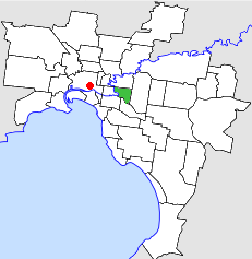
The City of Hawthorn was a local government area about 4 kilometres (2.5 mi) east of Melbourne, the state capital of Victoria, Australia, on the southeast bank of the Yarra River. The city covered an area of 9.71 square kilometres (3.75 sq mi), and existed from 1860 until 1994.

The Shire of Diamond Valley was a local government area about 20 kilometres (12 mi) northeast of Melbourne, the state capital of Victoria, Australia. The shire covered an area of 74.38 square kilometres (28.72 sq mi), and existed from 1964 until 1994.

The City of Box Hill was a local government area about 15 kilometres (9 mi) east of Melbourne, the state capital of Victoria, Australia. The city covered an area of 21.50 square kilometres (8.30 sq mi), and existed from 1927 until 1994.

The Shire of Upper Yarra was a local government area centred on the upper reaches of the Yarra Valley, about 60 kilometres (37 mi) east of Melbourne, the state capital of Victoria, Australia, extending eastwards into Victoria's interior. The shire covered an area of 1,732 square kilometres (668.7 sq mi), and existed from 1888 until 1994.
The Shire of Healesville was a local government area about 60 kilometres (37 mi) northeast of Melbourne, the state capital of Victoria, Australia. The shire covered an area of 466.20 square kilometres (180.0 sq mi), and existed from 1887 until 1994.

The Shire of Eltham was a local government area about 25 kilometres (16 mi) northeast of Melbourne, the state capital of Victoria, Australia. The shire covered an area of 277.13 square kilometres (107.0 sq mi), and existed from 1856 until 1994.

The Shire of Alexandra was a local government area located about 130 kilometres (81 mi) northeast of Melbourne, the state capital of Victoria, Australia. The shire covered an area of 2,197.31 square kilometres (848.4 sq mi), and existed from 1868 until 1994.

The Shire of Broadford was a local government area about 70 kilometres (43 mi) north of Melbourne, the state capital of Victoria, Australia. The shire covered an area of 576.3 square kilometres (222.5 sq mi), and existed from 1869 until 1994.

The Shire of Tungamah was a local government area in the Goulburn Valley region, about 240 kilometres (149 mi) northeast of Melbourne, the state capital of Victoria, Australia. The shire covered an area of 1,143 square kilometres (441.3 sq mi), and existed from 1878 until 1994.
The Big Peninsula Tunnel is a small river diversion tunnel on the upper Yarra River near McMahons Creek, around 80 km east of Melbourne, Victoria, Australia. The tunnel was dug in 1864, during the Victorian gold rush, by alluvial gold miners to provide access to the bed of the Yarra River. Big Peninsula Tunnel is a square section, about 2 metres high and wide, and approximately 25 metres long.
The Little Peninsula Tunnel is a small river diversion tunnel on the upper Yarra River near McMahons Creek, around 80 km East of Melbourne, Victoria, Australia. The tunnel was dug in the 1860s by alluvial gold miners to provide access to the bed of the Yarra River.

Dalhousie was an electoral district of the Legislative Assembly in the Australian state of Victoria from 1859 to 1927. It was based in north-western Victoria. The district had been named Electoral district of Anglesey. The district of Dalhousie was defined in the 1858 Electoral Act as :
THE ELECTORAL DISTRICT OF DALHOUSIE.
ANGLESEY. Bounded on the west by part of the eastern boundary of the County of Dalhousie, namely, by the River Goulburn from the confluence of Hughes's Creek to the confluence of Dabyminga Creek; thence by Dabyminga Creek to its source in the Great Dividing Range; on the south by the Great Dividing Range to the main source of the River Goulburn; on the east by the range dividing the waters of the main source of the Goulburn and Big Rivers from those of the Rubicon and Snod-por-dock Creek northward to Mount Torbrick; thence by Jerusalem Creek to its confluence with the River Goulburn; thence by the River Goulburn to the confluence of the River Delatite; thence by the River Delatite and its north-west arm to the Dividing Range between the last named arm and Septimus Creek; and on the north by that range to the source of Hughes's Creek; and thence by Hughes's Creek to its confluence with the River Goulburn, excepting the country included in the Boroughs of Seymour and Avenel ... DALHOUSIE. Commencing at the junction of the Rivers Campaspe and Coliban; thence by a line south-easterly to the source of the Mclvor or Patterson's Creek; thence by a line north-east to the confluence of Hughes's Creek with the River Goulburn; on the east by the River Goulburn until it joins the Dabyminga Creek, by that creek to its source in the Dividing Range; on
the south by the Dividing Range to the source of the River Coliban; and on the west by the last mentioned river to its junction with the River Campaspe, being the commencing point, excepting the country included in the electoral districts of the Kyneton Boroughs, Murray Boroughs, and Kilmore.

Sugarloaf Creek is a locality in central Victoria, Australia. It is located on the Sugarloaf Creek Road in the Shire of Mitchell local government area, 99 kilometres (62 mi) from the state capital, Melbourne. At the 2016 Australian Census Sugarloaf Creek had a population of 257. The Sugarloaf Creek itself is a tributary of the Goulburn River in Australia.
References
- ↑ Victorian Geographical Journal. Royal Geographical Society of Australasia (Victoria). 1894. p. 139.
- ↑ "Pioneers honored". The Age. 6 September 1977. p. 3. Retrieved 28 April 2015.
Waterways of the Goulburn Broken catchment, Victoria, Australia | |
|---|---|
| Rivers | |
| Creeks |
|
| Lakes | |
37°09′00″S145°17′00″E / 37.15°S 145.283333°E
| | This article about a location in Hume (region) is a stub. You can help Wikipedia by expanding it. |