
Murrumbidgee River, a major tributary of the Murray River within the Murray–Darling basin and the second longest river in Australia. It flows through the Australian state of New South Wales and the Australian Capital Territory. It descends 1,500 metres (4,900 ft) as it flows 1,485 kilometres (923 mi) in a west-northwesterly direction from the foot of Peppercorn Hill in the Fiery Range of the Snowy Mountains towards its confluence with the Murray River near Boundary Bend.

The Molonglo River, a perennial river that is part of the Murrumbidgee catchment within the Murray–Darling basin, is located in the Monaro and Capital Country regions of New South Wales and the Australian Capital Territory, in Australia.

The District of Belconnen is one of the original eighteen districts of the Australian Capital Territory (ACT), used in land administration. The district is subdivided into 27 divisions (suburbs), sections and blocks. The district of Belconnen is largely composed of Canberra suburbs.

The District of Gungahlin is one of the original eighteen districts of the Australian Capital Territory used in land administration. Gungahlin Region is one of fastest growing regions within Australia. The district is subdivided into divisions (suburbs), sections and blocks. Gungahlin is an Aboriginal word meaning either "white man's house" or "little rocky hill".

The Naas River, a perennial stream of the Murrumbidgee catchment within the Murray-Darling basin, is located in the Australian Capital Territory, Australia.

The Queanbeyan River, a perennial stream that is part of the Molonglo catchment within the Murray–Darling basin, is located in the Monaro and Capital Country regions of New South Wales and the Australian Capital Territory, in Australia. The river is 104 kilometres (65 mi) in length with a catchment area of 96,000 hectares. The Queanbeyan River and the Cotter River meet the potable water supply needs of the Canberra and Queanbeyan region and whose water quality is specifically protected under Federal legislation.

The Cotter River, a perennial river of the Murrumbidgee catchment within the Murray-Darling basin, is located in the Australian Capital Territory, Australia. The Cotter River, together with the Queanbeyan River, is one of two rivers that provides potable water to the Canberra and Queanbeyan region.
Orroral River, a perennial stream of the Murrumbidgee catchment within the Murray-Darling basin, is located in the Australian Capital Territory, Australia.
Scouting and Guiding in the Australian Capital Territory (ACT) of Australia is predominantly represented by the branch of Scouts Australia, and Girl Guides NSW and ACT, a member of Girl Guides Australia.

Murray County was one of the original Nineteen Counties in New South Wales and is now one of the 141 Lands administrative divisions of New South Wales. It included the area which is now part of Canberra and as far north as Lake George and Yass. It was originally bounded on the west by the Murrumbidgee River, on the east by the Shoalhaven River and on the north by the Yass River. A large area of the county was transferred to the Commonwealth government in 1909 in the Seat of Government Acceptance Act to make part of the Australian Capital Territory, along with land in Cowley County. Since then, the ACT border is now part of the western boundary. Part of the ACT border is determined by property boundaries in the Parish of Keewong, in the County of Murray; specifically the southern end of portions 177, 218, 211, 36, and 38. This is mentioned in the Seat of Government Acceptance Act of 1909.

Ginninderra is the name of the former agricultural lands surrendered to urban development on the western and north-western fringes of Canberra, the capital of Australia. Ginninderra corresponds with the watershed of Ginninderra Creek, which is now in part occupied by the Canberra districts of Belconnen and Gungahlin.

The Tumut River, a perennial stream that is part of the Murrumbidgee catchment within the Murray–Darling basin, is located in the Snowy Mountains and South West Slopes districts of New South Wales, Australia.
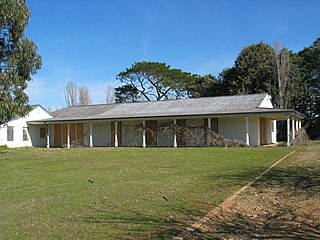
Gold Creek Homestead (1) is a 140-year-old stone and brick building located off Gungahlin Drive in Ngunnawal a north-western suburb of Canberra, Australia. It is adjacent to the Grove Ngunnawal retirement village currently being developed by Lend Lease.

Sullivans Creek, a partly perennial stream of the Murrumbidgee catchment within the Murray-Darling basin, is located in Canberra, Australian Capital Territory, Australia.
Jerrabomberra Creek, a partly perennial stream of the Murrumbidgee catchment within the Murray-Darling basin, is located in the Capital Country region spanning both New South Wales and the Australian Capital Territory, Australia.

Tuggeranong Creek, a partly perennial stream of the Murrumbidgee catchment within the Murray-Darling basin, is located in the Tuggeranong district of Canberra, within the Australian Capital Territory, Australia.

The Happy Jacks Creek, a perennial river that is part of the Murrumbidgee catchment within the Murray–Darling basin, is located in the Snowy Mountains region of New South Wales, Australia.
The Jeir Creek, a perennial river that is part of the Murrumbidgee catchment within the Murray–Darling basin, is located in the South West Slopes region of New South Wales, Australia.
The Peelwood Creek, a watercourse that is part of the Lachlan sub-catchment of the Murrumbidgee catchment within the Murray–Darling basin, is located in the South West Slopes region of New South Wales, Australia.
The Pudman Creek, a perennial stream that is part of the Lachlan sub-catchment of the Murrumbidgee catchment within the Murray–Darling basin, is located in the South West Slopes region of New South Wales, Australia.
