Tullamarine is a suburb in Melbourne, Victoria, Australia, 14 km (8.7 mi) north-west of Melbourne's Central Business District, located within the Cities of Brimbank, Hume and Merri-bek local government areas. Tullamarine recorded a population of 6,733 at the 2021 census.

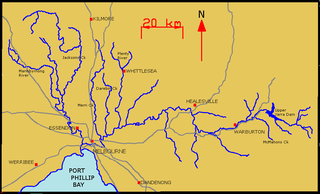
The Maribyrnong River is a perennial river of the Port Phillip catchment, located in the north–western suburbs of Melbourne, in the Australian state of Victoria.

Bulla is a locality and township in Melbourne, Victoria, Australia, 23 kilometres (14 mi) north-west of Melbourne's Central Business District, located within the City of Hume local government area. Bulla recorded a population of 668 at the 2021 census.
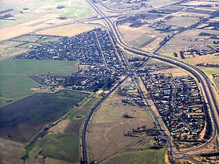
Diggers Rest is a suburb in Melbourne, Victoria, Australia. It is 28 km (17 mi) and 29 minutes north-west of Melbourne's Central Business District, located within the Cities of Hume and Melton local government areas. Diggers Rest recorded a population of 5,669 at the 2021 census.

Keilor is a suburb in Melbourne, Victoria, Australia, 16 km (9.9 mi) north-west of Melbourne's Central Business District, located within the Cities of Brimbank and Hume local government areas. Keilor recorded a population of 5,906 at the 2021 census.
Melton Highway links Melbourne's outer north-western suburbs of Melton and Taylors Lakes, connecting the Western Freeway and Calder Freeway to provide a more-direct route between Ballarat and Melbourne and Essendon airports; it has a Victorian route designation of C754.

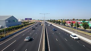
The Tullamarine Freeway, is a major urban freeway in Melbourne, Victoria, Australia, linking Melbourne Airport to the Melbourne City Centre. It carries up to 210,000 vehicles per day and is one of Australia's busiest freeways. The entire stretch of the Tullamarine Freeway bears the designation M2.

The Maribyrnong River Trail is a shared use path for cyclists and pedestrians, which follows the Maribyrnong River through the north western suburbs of Melbourne, Victoria, Australia.

The Loddon River, an inland river of the north–central catchment, part of the Murray-Darling basin, is located in the lower Riverina bioregion and Central Highlands and Loddon Mallee regions of the Australian state of Victoria. The headwaters of the Loddon River rise on the northern slopes of the Great Dividing Range east of Daylesford and descend to flow north into the Little Murray River, near Swan Hill. The river is impounded by the Cairn Curran and Laanecoorie reservoirs.

Riddells Creek is a town in Victoria, Australia, located in Wurundjeri Country and the Shire of Macedon Ranges. It is located in between the cities of Bendigo and Melbourne. Riddells Creek is also the name of the main watercourse which flows through the township, and which is a tributary of Jacksons Creek to the south. The town is served by Riddells Creek railway station on the Bendigo line. At the 2021 census, Riddells Creek had a population of 3574.

Gisborne is a town in the Macedon Ranges, located in Wurundjeri Country about 54 kilometres (34 mi) north-west of Melbourne, Victoria, Australia. It is the largest town in the Macedon Ranges Shire, with a population of 14,432 as of June 2021 in the Gisborne district region.
Buttlejorrk is a parish of the County of Bourke located to the west of Sunbury, in Victoria, Australia and a neighbourhood within the locality of Diggers Rest. It was named in 1839 by the surveyor William Darke. A township developed and was initially known as Aitken's Gap. By the 1890s it had commonly become known as Buttlejorrk. A Post Office opened on 5 September 1856 as The Gap, was renamed Buttlejork (sic) in 1875 and closed in 1919. One of the early settlers in the area was George Millett. George and his wife Suzanne established the Bald Hill Hotel, the first staging stop out of Melbourne on the road to the goldfields at Bendigo. The hotel was licensed in 1853 until 1907. The Aitken's Gap Gaol, now located in the forecourt of the Sunbury Police Station stood beside the hotel

The Kororoit Creek is a watercourse of the Port Phillip catchment, rising in the outer north western suburbs of Melbourne, in the Australian state of Victoria.

Gardiners Creek, originally known as Kooyongkoot Creek, is an urban stream in the eastern suburbs of Melbourne, and part of the Yarra River catchment.
The Yarra River is a river in East-Central Victoria, Australia that flows through the city of Melbourne. This article contains explanations and lists of the river's tributaries and other geographic features. The river flows atop layers of silt that built up within an ancient river valley around 10,000-15,000 years ago.

The Deep Creek is a watercourse of the Port Phillip catchment, located in the outer north western suburbs of Melbourne, in the Australian state of Victoria.
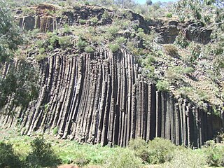
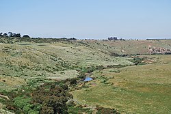
The Organ Pipes National Park, abbreviated as OPNP, is a national park located in the Central region of Victoria, Australia. The 121-hectare (300-acre) protected area was established with the focus on conservation of the native flora and fauna, and preservation of the geological features in the Jacksons Creek, a part of the Maribyrnong valley, north-west of Melbourne. It is situated in a deep gorge in the grassy, basalt Keilor Plains.

The Yarrowee River is a perennial river of the Corangamite catchment, located in the Central Highlands region of the Australian state of Victoria.
The Jacksons Creek biik wurrdha Regional Parklands is a park system and series of nature reserves located in the northern outer area of Melbourne near Sunbury, in Victoria, Australia.