Dartmouth Dam is a large rock-fill embankment dam with an uncontrolled chute spillway across the Mitta Mitta, Gibbo and Dart rivers, the Morass Creek and a number of small tributaries. The dam is located near Mount Bogong in the north-east of the Australian state of Victoria. The dam's purpose includes irrigation, the generation of hydro-electric power, water supply and conservation. The impounded reservoir is called Dartmouth Reservoir, sometimes called Lake Dartmouth. The Dartmouth Power Station, a hydro-electric power station that generates power to the national grid, is located near the dam wall.

The Eildon Dam is a rock and earth-fill embankment dam with a controlled spillway across the Goulburn River, is located between the regional towns of Mansfield and Eildon within Lake Eildon National Park, in the Alpine region of Victoria, Australia. The dam's purpose is for the supply of potable water, irrigation, and the generation of hydroelectricity. The impounded reservoir is called Lake Eildon.

Lake Eppalock is an Australian reservoir in North Central Victoria about 130 kilometres (81 mi) northwest of Melbourne. It was formed by the construction of a major earth and rockfill embankment dam, known as Eppalock Dam, with a controlled chute spillway across the Campaspe and the Coliban rivers. The lake is situated between the regional population centres of Bendigo and Heathcote and serves as a major water storage facility for both places, as well as the Campaspe irrigation district. The lake also serves as a popular sports and recreational facility.

The Blowering Dam is a major ungated rock fill with clay core embankment dam with concrete chute spillway impounding a reservoir under the same name. It is located on the Tumut River upstream of Tumut in the Snowy Mountains region of New South Wales, Australia. Purposes for the dam include flood mitigation, hydro-power, irrigation, water supply and conservation. The dam is part of the Snowy Mountains Scheme, a vast hydroelectricity and irrigation complex constructed in south-east Australia between 1949 and 1974 and now run by Snowy Hydro.

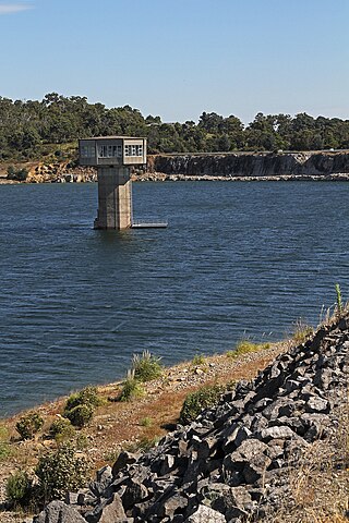
Googong Dam is a minor ungated earth and rock fill with clay core embankment dam with concrete chute spillway plus a nearby 13 metres (43 ft) high earthfill saddle embankment across the Queanbeyan River upstream of Queanbeyan in the Capital Country region of New South Wales, Australia. The dam's purpose includes water supply for Canberra and Queanbeyan. The impounded reservoir is called Googong Reservoir.

The Upper Nepean Scheme is a series of dams and weirs in the catchments of the Cataract, Cordeaux, Avon and Nepean rivers of New South Wales, Australia. The scheme includes four dams and two weirs, and a gravity-fed canal system that feeds into a large storage reservoir to provide water to the Macarthur and Illawarra regions, the Wollondilly Shire, and metropolitan Sydney. The four dams and associated infrastructure are individually listed on the New South Wales State Heritage Register.

The Maroon Dam is a rock and earth-fill embankment dam with an un-gated spillway across the Burnett Creek that is located in the South East region of Queensland, Australia. The main purpose of the dam is for irrigation of the Scenic Rim Regional Council region. The impounded reservoir is also called Maroon Dam.

The Burdekin Falls Dam, also known as the Burdekin Dam, is a concrete gravity dam with an uncontrolled spillway across the Burdekin River, located south west of Ayr, and Home Hill in the Shire of Burdekin, North Queensland, Australia. Built for the purpose of irrigation, the reservoir is called Lake Dalrymple. Burdekin Falls Dam is managed by SunWater. Water from the reservoir is also used to replenish downstream aquifers.

The Prospect Reservoir is a heritage-listed 50,200-megalitre potable water supply and storage reservoir created by the Prospect Dam, across the Prospect Creek located in the Western Sydney suburb of Prospect, in New South Wales, Australia. The eastern bounds of the reservoir are a recreational area and the western periphery are within the bounds of Western Sydney Parklands. It was added to the New South Wales State Heritage Register on 18 November 1999.

The Little Nerang Dam is a concrete gravity dam with an un-gated spillway across the Little Nerang Creek that is located in the South East region of Queensland, Australia. The main purpose of the dam is for potable water supply of the Gold Coast region. The impounded reservoir is also called Little Nerang Dam. The dam was closed to the public in 2013 due to safety concerns.
The William Hovell Dam is a rock and earth-fill embankment dam with a flip bucket chute spillway across the King River, operated by Pacific Blue and located in the Hume region of Victoria, Australia. The purposes of the dam are for irrigation and the generation of hydroelectricity. The impounded reservoir is called Lake William Hovell.

The Upper Yarra Reservoir is located east of Melbourne, Victoria, Australia, beyond Warburton within the locality of Reefton. Water from Upper Yarra Reservoir supplies towns in the upper Yarra Valley, and Silvan Reservoir, which transfers water to most parts of Melbourne.
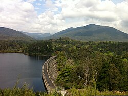
The Nillahcootie Dam, a rock and earth-fill embankment dam with a unique Gothic arch-shaped crest spillway across the Broken River that is located near Mansfield, in the Alpine region of Victoria, Australia. The dam's purpose is for the supply of potable water and for irrigation. The impounded reservoir is called Lake Nillahcootie.

The Staines Reservoirs are two large pumped storage reservoirs sitting to the east of the King George VI Reservoir near Heathrow airport in Surrey within the Colne Valley regional park. The village of Stanwell is mainly to the north east, and the town of Staines is to the south.
Cardinia Reservoir is an Australian man-made water supply saddle dam reservoir. The 287,000 ML water store is located in Emerald–Clematis–Dewhurst in south-eastern suburbs of Melbourne, Victoria. Construction started in May 1970 and was completed in 1973 at a cost of more than A$11.4 million. The dam that creates the impoundment is called the Cardinia Dam.

Talbingo Dam is a major ungated rock fill with clay core embankment dam with concrete chute spillway across the Tumut River upstream of Talbingo in the Snowy Mountains region of New South Wales, Australia. The impounded reservoir is called Talbingo Reservoir.
The O'Shannassy Reservoir is an Australian man-made water supply dammed reservoir. The 3.123 GL water store across the O'Shannassy River is located near the locality of McMahons Creek, approximately 80 kilometres (50 mi) east of Melbourne, Victoria. The dam that creates the impoundment is called the O'Shannassy Dam.
The Watts River is a perennial river of the Port Phillip and Western Port catchment, located in the Healesville area, in the Central region of the Australian state of Victoria.
William Davidson (1844–1920), was an Australian civil engineer who headed the Melbourne Water Supply department, and was responsible for important improvements to Melbourne's water supply system during sustained periods of drought.
Water management in Victoria deals with the management of water resources in and by the Australian State of Victoria.