Darebin Creek

Last updated
Darebin Creek
Darebin Creek.JPG
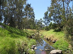
Darebin Creek, through Heidelberg West
Location
Country Australia
State Victoria
Physical characteristics
Length~30 km (19 mi)
Basin sizeUnknown

Darebin Creek is a creek that runs through the northern suburbs of Melbourne, Victoria, Australia. It is the main watercourse of the Darebin Valley and a major tributary of the Yarra River. For tens of thousands of years it was used as a food and tool source sustainably by the Wurundjeri people, Indigenous Australians of the Kulin nation alliance, who spoke variations of the Woiwurrung language group.

Contents

The creek rises on the northern urban fringe of Melbourne north of the suburb of Epping, following a general southerly route and meeting the Yarra at Alphington. The creek forms much of the municipal boundary between the City of Darebin and City of Banyule. Formerly an intermittent stream, increased stormwater runoff with urbanisation of the Darebin Creek catchment has resulted in permanent water flow.

The creek runs through Darebin Parklands, a large nature reserve one or two kilometres northwest of the junction at which the creek meets the Yarra. The Darebin Creek Trail runs along the banks in the lower reaches of the creek.

Geography

The Yarra River and its tributaries Yarra mullum locator map.PNG
The Yarra River and its tributaries

The Darebin Creek's headwaters begin in Wollert, South Morang and even as far as Woodstock where they flow in a roughly southerly direction before meeting north of Epping.

Settlements

Alphington - 4,400
Ivanhoe - 10,600
Thornbury - 17,434
Preston - 29,925
Bundoora - 24,000
Lalor - 19,500
Epping - 19,200
South Morang - 12,300

Parklands

Excellent examples of remnants of Melbourne’s early agricultural history can be seen within the Darebin Parklands in Alphington and Ivanhoe. The olive and other fruit trees within the park are more than a century old. The Darebin Creek Trail links many of these parks as it follows the course of the creek for much of its length. Below is a list of parklands that adjoin the Darebin Creek, listed from downstream to upstream: [1]

Related Research Articles

<span class="mw-page-title-main">City of Whittlesea</span> Local government area in Victoria, Australia

The City of Whittlesea is a local government area located in the outer northern suburbs of Melbourne, the state capital of Victoria, Australia. The city covers an area of 490 square kilometres (189.2 sq mi), and in June 2018, it had a population of 223,322.

<span class="mw-page-title-main">Fairfield, Victoria</span> Suburb of Melbourne, Victoria, Australia

Fairfield is a suburb in Melbourne, Victoria, Australia, 6 km (3.7 mi) north-east of Melbourne's Central Business District, located within the Cities of Darebin and Yarra local government areas. Fairfield recorded a population of 6,535 at the 2021 census.

<span class="mw-page-title-main">Bundoora</span> Suburb of Melbourne, Victoria, Australia

Bundoora is a suburb in Melbourne, Victoria, Australia, 15 km (9.3 mi) north-east of Melbourne's Central Business District, located within the Cities of Banyule, Darebin and Whittlesea local government areas. Bundoora recorded a population of 28,068 at the 2021 census.

<span class="mw-page-title-main">Alphington, Victoria</span> Suburb of Melbourne, Victoria, Australia

Alphington is a suburb in Melbourne, Victoria, Australia, 7 km (4.3 mi) north-east of Melbourne's Central Business District, located within the Cities of Darebin and Yarra local government areas. Alphington recorded a population of 5,702 at the 2021 census.

Kingsbury is a suburb in Melbourne, Victoria, Australia, 12 km (7.5 mi) north-east of Melbourne's Central Business District, located within the City of Darebin local government area. Kingsbury recorded a population of 3,460 at the 2021 census.

<span class="mw-page-title-main">Reservoir, Victoria</span> Suburb of Melbourne, Victoria, Australia

Reservoir ( "REZ-ə-vore") is a suburb in Melbourne, Victoria, Australia, 11 km (6.8 mi) north of Melbourne's Central Business District, located within the City of Darebin local government area. Reservoir recorded a population of 51,096 at the 2021 census.

<span class="mw-page-title-main">Thornbury, Victoria</span> Suburb of Melbourne, Victoria, Australia

Thornbury is an inner-city suburb in Melbourne, Victoria, Australia, 7 km (4.3 mi) north-east of Melbourne's Central Business District, located within the City of Darebin local government area. Thornbury recorded a population of 19,005 at the 2021 census.

<span class="mw-page-title-main">Epping, Victoria</span> Suburb of Melbourne, Victoria, Australia

Epping is a suburb in Melbourne, Victoria, Australia, 18 km (11 mi) north of Melbourne's Central Business District, located within the City of Whittlesea local government area. Epping recorded a population of 33,489 at the 2021 census.

<span class="mw-page-title-main">Thomastown railway station, Melbourne</span> Railway station in Melbourne, Australia

Thomastown railway station is located on the Mernda line in Victoria, Australia. It serves the northern Melbourne suburb of Thomastown, and it opened on 23 December 1889.

<span class="mw-page-title-main">Merri Creek</span> River in Victoria, Australia

The Merri Creek is a waterway in southern parts of Victoria, Australia, which flows through the northern suburbs of Northcote. It begins near Wallan north of Melbourne and flows south for 70 km until it joins the Yarra River at Dights Falls. The area where the creek meets the river was traditionally the location for large gatherings of the Wurundjeri people and is suspected to have been the location for one of the earliest land treaties in Australia between Indigenous Australians and European settlers.

Mill Park is a suburb of Melbourne, Victoria, Australia, 18 km north-east of Melbourne's central business district, located within the City of Whittlesea local government area. Mill Park recorded a population of 28,712 at the 2021 census.

<span class="mw-page-title-main">Division of Scullin</span> Australian federal electoral division

The Division of Scullin is an Australian Electoral Division in the state of Victoria. It is located in the outer northern suburbs of Melbourne, including Epping, Lalor, Mill Park, South Morang, Thomastown, and Bundoora.

<span class="mw-page-title-main">Koonung Creek</span> River in Victoria, Australia

Koonung Creek is a small tributary of the Yarra River in Melbourne's east. The creek originates in Nunawading near Springvale Road, and flows to join the Yarra at the border between Ivanhoe East, Bulleen and Balwyn North. The place the two waterways meet forms the borders between these suburbs. Bushy Creek is a tributary to the creek, joining near Elgar Park in Mont Albert North. A shared use path follows the course of the creek, known as the Koonung Creek Trail.

<span class="mw-page-title-main">Darebin Creek Trail</span>

The Darebin Creek Trail is a shared use path for cyclists and pedestrians which follows Darebin Creek in the inner and outer northern suburbs of Melbourne, Victoria, Australia.

<span class="mw-page-title-main">Northern Pipe Trail</span>

The Northern Pipe Trail, is a shared-use path for cyclists and pedestrians that follows Cheddar and St Georges roads in the northern suburbs of Reservoir, Preston and Thornbury in Melbourne, Victoria, Australia.

<span class="mw-page-title-main">City of Preston (Victoria)</span> Local government area in Victoria, Australia

The City of Preston was a local government area about 11 kilometres (7 mi) north-northeast of Melbourne, the state capital of Victoria, Australia. The city covered an area of 37.05 square kilometres (14.31 sq mi), and existed from 1871 until 1994.

<span class="mw-page-title-main">Main Yarra Trail</span>

The Yarra Trail is a shared-use path for cyclists and pedestrians, which follows the Yarra River through the northeastern suburbs of Melbourne, Victoria, Australia.

<span class="mw-page-title-main">Parklands adjoining the Yarra River</span>

The Yarra River is a river in southern Victoria, Australia that flows through the city of Melbourne. There are many parklands, including state parks and national parks, that adjoin the river along its 250 km length. Every park listed has walking tracks, smaller parks usually have unsealed paths, while bigger parks will have sealed pathways suitable for walking and cycling. The Yarra River Trail runs along much of the length of the river's lower reaches through Melbourne. Most parks listed have parking available, the quality and quantity of which varies according to the size of the park. Dogs are not permitted in parklands adjoining the river unless otherwise stated in special off-lead areas.

Glass Creek is a waterway flowing through the inner-eastern suburbs of Melbourne. It is a minor tributary of the Yarra River and now largely runs through a series of underground drains.

References

  1. Melway, Edition 36, 2009

37°47′03″S145°02′24″E / 37.78417°S 145.04000°E / -37.78417; 145.04000