Dandenong Valley Parklands | |
---|---|
Type | Metropolitan parks |
Location | South east suburbs of Melbourne, Victoria, Australia |
Coordinates | 37°53′48″S145°11′47″E / 37.896711°S 145.196394°E |
Area | 1,306 hectares |
Elevation | 100 m |
Opened | 1976 |
Managed by | Primarily Parks Victoria (also Melbourne Water, City of Monash, City of Knox, City of Whitehorse) |
Visitors | 1.5 million(in 2006) |
Status | Open all year |
Paths | Dandenong Creek Trail, Scotchmans Creek Trail, EastLink Trail |
Vegetation | Swampy woodland, swampy riparian woodland, valley heathy forest |
Website | Parks Victoria |
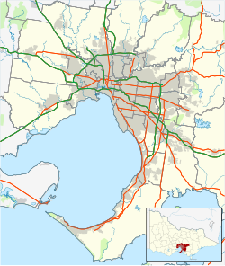
The Dandenong Valley Parklands are a collection of public parks and open space reserves along the Dandenong Creek, an urban creek in southeastern Melbourne, Victoria, Australia. [1] [2] The term refers only to the parklands along and in close proximity to the middle main stem of Dandenong Creek, stretching from Boronia Road in the north to Wellington Road in the south [3] through the suburbs of Vermont South, Wantirna, Wantirna South and Wheelers Hill, [4] even though there are a lot more parks and reserves along the extended catchment of the creek.
The parklands are separated into six individual parks, roughly following the middle Dandenong Creek north-south for about 10 km (6.2 mi). [5] These include a range of landscapes including remnant bushland, grassland, artificial lakes, retarding basins, wetlands, and open parkland. The parklands form a large part of the habitat corridor of Dandenong Creek, along with some nearby public spaces such as the Police Road Retarding Basin/Tirhatuan Park, Dandenong Police Paddocks Reserve, Dandenong Wetlands (Melbourne Water Recreation Area) and Churchill National Park. [5] : 1
The land of the Dandenong Valley Parklands was reserved by the Melbourne and Metropolitan Board of Works in 1973 as part of a plan to create more public open spaces. Plans for the Parklands were originally announced in 1975, and the first publicly accessible section, Jells Park, was opened in 1976. [5] : 2
Management of the Parklands was transferred from Melbourne Water to the newly formed Melbourne Parks and Waterways in 1994. This organisation was absorbed by Parks Victoria in 1996, and ownership of the Parklands was formally transferred to Parks Victoria in 1997. Following the formal termination of Melbourne Parks and Waterways in 2001, the land was transferred to the State Government of Victoria, and now exists as crown land. [6]
Two civic reports on the Dandenong Valley Parklands have been written, titled Future Directions Plans. They were released in 1995 (by Melbourne Parks and Waterways) and 2006 (by Parks Victoria). [5]
In 1989, the Friends of Dandenong Valley Parklands was formed, and continues to contribute to maintenance of the parks, including revegetation, weeding, installing nest boxes, and habitat monitoring. [7] [8]
The Dandenong Ranges are a set of low mountain ranges in Victoria, Australia, approximately 35 km (22 mi) east of the state capital Melbourne. A minor branch of the Great Dividing Range, the Dandenongs consist mostly of rolling hills, rising to 633 m (2,077 ft) at Mount Dandenong, as well as steeply weathered valleys and gullies covered in thick temperate rainforest, predominantly of tall mountain ash trees and dense ferny undergrowth. The namesake Dandenong Creek and most of its left-bank tributaries originate from headwaters in these mountain ranges. Two of Melbourne's most important storage reservoirs, the Cardinia and Silvan Reservoir, are also located within the Dandenongs.
Wantirna is a suburb in Melbourne, Victoria, Australia, 24 km east of Melbourne's Central Business District, located within the City of Knox local government area. Wantirna recorded a population of 14,237 at the 2021 census.
The Maribyrnong River is a perennial river of the Port Phillip catchment, located in the north–western suburbs of Melbourne, in the Australian state of Victoria.
Sassafras is a locality and township within Greater Melbourne, beyond the Melbourne metropolitan area Urban Growth Boundary, 43 km east of Melbourne's Central Business District, located within the City of Knox and Shire of Yarra Ranges local government areas. Sassafras recorded a population of 970 at the 2021 census.
Dandenong is a southeastern suburb of Melbourne, Victoria, Australia, about 29 km (18 mi) from the Melbourne CBD. It is the council seat of the City of Greater Dandenong local government area, with a recorded population of 30,127 at the 2021 census. Situated mainly on the northwest bank of the lower Dandenong Creek, it is 21.6 km (13.4 mi) from the eponymous Dandenong Ranges to its northeast and completely unrelated in both location and nature of the settlement.
The Maribyrnong River Trail is a shared use path for cyclists and pedestrians, which follows the Maribyrnong River through the north western suburbs of Melbourne, Victoria, Australia.
Melbourne is Australia's second largest city and widely considered to be a garden city, with Victoria being nicknamed "the Garden State". Renowned as one of the most livable cities in the world, there is an abundance of parks, gardens and green belts close to the CBD with a variety of common and rare plant species amid landscaped vistas, pedestrian pathways, and tree-lined avenues, all managed by Parks Victoria.
Mullum Mullum Creek is a creek in the outer eastern suburbs of Melbourne, Victoria, Australia. It is the main watercourse of the Mullum Mullum Valley, a tributary of the Yarra River and Yarra Valley. For tens of thousands of years it was used as a food and tool source sustainably by the Wurundjeri people, Indigenous Australians of the Kulin nation, who spoke variations of the Woiwurrung language group.
Waterways is a suburb in Melbourne, Victoria, Australia, 25 km (16 mi) south-east of Melbourne's Central Business District, located within the City of Kingston local government area. Waterways recorded a population of 2,422 at the 2021 census.
The Dandenong Creek Trail is a shared use path for cyclists and pedestrians, which follows Dandenong Creek through the outer eastern and south-eastern suburbs of Melbourne, Victoria, Australia.
Jells Park is a public park in Wheelers Hill, a southeastern suburb of Melbourne, Victoria, Australia. The park opened on 30 April 1976 and is named after Joseph Jell, a cattle grazier who worked in the area in the mid-late 1800s. The park attracts in excess of 900,000 visitors a year.
Bushy Park Wetlands is a 30-hectare (74-acre) conservation park in Glen Waverley, Victoria, Australia. On the edge of suburbia, it is bounded by Dandenong Creek and houses along King Arthur Drive and Knights Drive. There is a cycling and walking path, and a bird watching hide, where egrets, pelicans, coots, dusky moorhen, ibis and occasionally spoonbill can be observed. It is accessible from the end of Highbury Road, or at the Drummies Bridge Reserve off High Street Road. It is also connected by the Dandenong Creek Trail to Shepherds Bush Park, Koomba Park and Napier Park.
Koomba Park is one of the parks comprising the Dandenong Valley Parklands in the eastern suburbs of Melbourne, Australia. It consists of 92 hectares of which 33 hectares are publicly accessible, and is bounded by Dandenong Creek, Boronia Road, EastLink, Mountain Highway and Burwood Highway in a clockwise direction. It is managed primarily by VicRoads and Parks Victoria. The park opened in December 1981, and its land was previously used for cattle grazing and apple orchards. The surrounding area is still used for grazing. There are three major power transmission lines running through the park: Rowville-Templestowe Single Circuit Southern, and Rowville-Ringwood.
The Dandenong Creek is an urban creek of the Port Phillip catchment, located in the eastern and south-eastern Greater Melbourne region of the Australian east coast state of Victoria. The creek descends approximately 550 metres (1,800 ft) over its course of 53 kilometres (33 mi) before joining the Eumemmerring Creek to form the Patterson River and eventually draining into the Beaumaris Bay.
The Scotchmans Creek Trail is a shared use path for cyclists and pedestrians, which follows Scotchmans Creek through the eastern suburbs of Melbourne, Victoria, Australia.
The Blind Creek Trail, in the outer eastern suburbs of Melbourne, in the Australian state of Victoria, is a shared-use path for cyclists and pedestrians, which follows the Blind Creek from the Dandenong Creek Trail in Wantirna South to the Ringwood - Belgrave Rail Trail in Boronia.
Melbourne is the capital city of southeastern Australian state of Victoria and also the nation's second most populous city, and has been consistently voted one of the most liveable cities in the world. Located on the northern/eastern coastal plains of Port Phillip Bay, the city is one of the drier capital cities in Australia, but due to its relatively flat terrain and the runoffs fed from surrounding highlands, still has many lakes, ponds and wetlands, mainly managed by Melbourne Water and Parks Victoria. The larger waterbodies are used for water sports, mostly boating but some are used for recreational activities like swimming, water skiing or model boating.
The EastLink Trail is a shared use path for cyclists and pedestrians in the outer eastern/southeastern suburbs of Melbourne, Victoria, Australia. The trail gets its name from the north-south EastLink tollway, along which it follows for most of its length from Ringwood to Dandenong, until it joins the Dandenong Creek Trail near the Dandenong Bypass bridge at the tri-suburban junction between Dandenong, Dandenong South and Keysborough.
Glass Creek is a waterway flowing through the middle ring eastern suburbs of Melbourne. It is a minor tributary of the Yarra River and now largely runs through a series of underground drains.
The Eastern Suburbs of Melbourne, Victoria, Australia, are a major metropolitan region encompassing a diverse range of residential, commercial, and natural areas. This region is generally considered to stretch from around 15 kilometres (9.3 mi) east of Melbourne’s Central Business District (CBD) and extends to the foot of the Dandenong Ranges. The Eastern Suburbs are distinct from Melbourne's Inner Eastern Suburbs, lying further out from the city and possessing a unique blend of suburban character, parklands, and proximity to natural attractions.