
The Shire of Mitchell is a local government area in the Hume region of Victoria, Australia, located North of Melbourne. It covers an area of 2,862 square kilometres (1,105 sq mi) and, in June 2018, had a population of 44,299. It includes the towns of Broadford, Kilmore, Seymour, Tallarook, Pyalong and Wallan. It was formed in 1994 from the amalgamation of the Shire of Pyalong, the Shire of Kilmore, most of the Shire of Broadford, and parts of the Shire of McIvor and Rural City of Seymour.
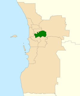
The Division of Swan is an Australian electoral division located in Western Australia.

The Division of Bruce is an Australian Electoral Division in the state of Victoria. The division is located in the south-eastern suburbs of Melbourne. It covers an area of approximately 115 square kilometres (44 sq mi) including the suburbs of Dandenong North, Doveton, Endeavour Hills, Eumemmerring, Hallam, Lysterfield South, Narre Warren and Narre Warren North; and parts of Berwick, Dandenong, Harkaway, Mulgrave, Narre Warren South, Noble Park and Noble Park North.

The Diamond Creek Trail is a shared use path for cyclists and pedestrians, which follows Diamond Creek through the north eastern outer suburbs of Melbourne, Victoria, Australia.

The University of Divinity is an Australian collegiate university of specialisation in divinity. It is constituted by eleven theological colleges from eight denominations. The University of Divinity is the direct successor of the second oldest degree-granting authority in the State of Victoria, the Melbourne College of Divinity. The university's chancery and administration are located in Kew, a suburb of Melbourne in the state of Victoria.

Mount Torbreck is a mountain in Victoria, Australia 150 km from Melbourne. The mountain was listed as a place that could be declared as an alpine resort in The Alpine Resorts Act 1983, however no resort was ever developed on the site and it was recommended to be changed to a natural and scenic features reserve in 1994.
The Monash University Accident Research Centre (MUARC) is a research institute in the injury prevention field. The centre is located at the Clayton Campus of Monash University in Victoria, Australia.

Caribbean Gardens was a 100 acres (0.40 km2) market, gardens and amusement park located in the outer eastern suburb of Scoresby in Melbourne, Australia, on the north/west side of Caribbean Lake, a large 1.2 km (0.75 mi) long artificial lake along the northern (right) bank of Corhanwarrabul Creek.

Bushy Park Wetlands is a 30-hectare (74-acre) conservation park in Glen Waverley, Victoria, Australia. On the edge of suburbia, it is bounded by Dandenong Creek and houses along King Arthur Drive and Knights Drive. There is a cycling and walking path, and a bird watching hide, where egrets, pelicans, coots, dusky moorhen, ibis and occasionally spoonbill can be observed. It is accessible from the end of Highbury Road, or at the Drummies Bridge Reserve off High Street Road. It is also connected by the Dandenong Creek Trail to Shepherds Bush Park, Koomba Park and Napier Park.

The Scotchmans Creek Trail is a shared use path for cyclists and pedestrians, which follows Scotchmans Creek through the eastern suburbs of Melbourne, Victoria, Australia.

The Mullum Mullum Creek Trail is a shared use path for cyclists and pedestrians, which follows Mullum Mullum Creek in the outer eastern suburbs in Melbourne, Victoria, Australia.
Electoral district of Noble Park was an electoral district of the Legislative Assembly in the Australian state of Victoria.

The Shire of Upper Yarra was a local government area centred on the upper reaches of the Yarra Valley, about 60 kilometres (37 mi) east of Melbourne, the state capital of Victoria, Australia, extending eastwards into Victoria's interior. The shire covered an area of 1,732 square kilometres (668.7 sq mi), and existed from 1888 until 1994.
The Shire of Yea was a local government area about 110 kilometres (68 mi) northeast of Melbourne, the state capital of Victoria, Australia. The shire covered an area of 1,392.32 square kilometres (537.6 sq mi), and existed from 1869 until 1994. The shire's population was dominated by the town of Yea.

The Shire of Broadford was a local government area about 70 kilometres (43 mi) north of Melbourne, the state capital of Victoria, Australia. The shire covered an area of 576.3 square kilometres (222.5 sq mi), and existed from 1869 until 1994.

Warrandyte State Park is a state park, located in Warrandyte, east of Melbourne, Victoria on the banks of the Yarra River and surroundings. The park comprises 586 hectares of remnant bushland in various locations throughout Warrandyte and Wonga Park around Pound Bend, Fourth Hill, Black Flat, Yarra Brae and various other locations in the area. It hosts many significant geographical, environmental, archaeological and historical sites, such as the site of the first gold discovery in Victoria in 1851 and preserves the sites of former gold mines and tunnels. It is a popular destination for school and community groups and is frequented by local bush walkers and hikers.
The You Yangs Regional Park is a park in southern central Victoria, Australia. The park encompasses much of the southern areas of the You Yangs, a granite range that rises from the Werribee Plains, 60 km southwest of Melbourne. The park is operated and managed by Parks Victoria and is open during daylight hours.

The Australian Jazz Museum (AJM), incorporating the Victorian Jazz Archive (VJA), is located in Wantirna, Victoria. It is an incorporated association arising out of a meeting held in Sydney on 23 June 1996 to address the growing concern among the jazz community that the rich Australian jazz heritage was at risk of being lost.
The Darebin International Sports Centre (DISC) is an athletic facility in Thornbury, Victoria, Australia. DISC is the home of the State Lawn Bowls Centre, the State Cycling Centre and the State Football Centre.
The Mordialloc-Cheltenham Community Hospital was a hospital in the suburb of Parkdale, Victoria, Australia.