The Budj Bim National Park, formerly known as Mount Eccles National Park, is a national park located in the Western District of Victoria, Australia. The 5,470-hectare (13,500-acre) national park is situated approximately 270 kilometres (170 mi) west of Melbourne and approximately 15 kilometres (9.3 mi) southwest of Macarthur. It derives its name from Budj Bim, formerly Mount Eccles, which is situated in the north-east of the park.

Stawell, is an Australian town in the Wimmera region of Victoria 237 kilometres (147 mi) west-north-west of the state capital, Melbourne. Located within the Shire of Northern Grampians local government area, it is a seat of local government for the shire and its main administrative centre. At the 2016 census, Stawell had a population of 6,032.

Nhill is a town in the Wimmera, in western Victoria, Australia. Nhill is located on the Western Highway, halfway between Adelaide and Melbourne. At the 2011 census, Nhill had a population of 2278. "Nhill" is believed to be a Wergaia word meaning "early morning mist rising over water" or "white mist rising from the water".

Dimboola is a town in the Shire of Hindmarsh in the Wimmera region of western Victoria, Australia, 334 kilometres north-west of Melbourne.
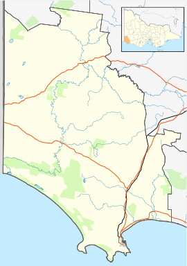
The Western District comprises western regions of the Australian state of Victoria. It is said to be an ill–defined district, sometimes incorrectly referred to as an economic region,. The district is located within parts of the Barwon South West and the Grampians regions; extending from the south-west corner of the state to Ballarat in the east and as far north as Ararat. The district is bounded by the Wimmera district in the north, by the Goldfields district in the east, by Bass Strait and the Southern Ocean in the south, and by the South Australian border in the west. The district is well known for the production of wool. The most populated city in the Western District is the Ballarat region, with 96,940 inhabitants.

Warracknabeal is a wheatbelt town in the Australian state of Victoria. Situated on the banks of the Yarriambiack Creek, 330 km north-west of Melbourne, it is the business and services centre of the northern Wimmera and southern Mallee districts, and hosts local government offices of the Shire of Yarriambiack. At the 2011 census Warracknabeal district had a population of 2,745, of which 2,340 lived in the town.

St Arnaud is a town in the Wimmera region of Victoria, Australia, 244 kilometres north west of the capital Melbourne. It is in the Shire of Northern Grampians local government area. At the 2011 census, St Arnaud had a population of 2,619.

Kaniva is a town in Victoria, Australia. It is located on the Western Highway, north of Little Desert National Park, in the Shire of West Wimmera local government area. It is located roughly 25 kilometres (16 mi) east of the South Australian border and 43 kilometres (27 mi) east of Bordertown. At the 2016 census, Kaniva had a population of 803. The town is commonly used as a rest point for those travelling between Melbourne and Adelaide. The Kaniva region has some rare flora and fauna. The rare south-eastern red-tailed black cockatoo is found in the region. The Shire of West Wimmera prohibits the felling of dead trees to ensure that they have adequate nesting sites.

Allestree is a small town in Victoria, Australia. It is located along the Princes Highway, north-east of Portland. At the 2016 census, Allestree and the surrounding area recorded a population of 128.

Donald is a town in Victoria, Australia, located on the Richardson River, at the junction of Sunraysia Highway and Borung Highway, in the Shire of Buloke. At the 2016 census, it had a population of 1,498.

Dartmoor is a rural township on the Princes Highway and the Glenelg River between Heywood and the South Australian border, in southwestern Victoria. At the 2011 census, Dartmoor had a population of 263.
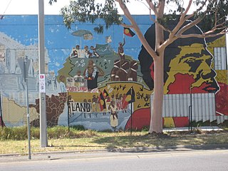
The Dhauwurd Wurrung, also known as the Gunditjmara or Gunditjamara, are an Aboriginal Australian people of southwestern Victoria. They are the traditional owners of the areas now encompassing Warrnambool, Port Fairy, Woolsthorpe and Portland. Their land includes much of the Budj Bim heritage areas.
Land councils, also known as Aboriginal land councils, or land and sea councils, are Australian community organisations, generally organised by region, that are commonly formed to represent the Indigenous Australians who occupied their particular region before the arrival of European settlers. They have historically advocated for recognition of traditional land rights, and also for the rights of Indigenous people in other areas such as equal wages and adequate housing.
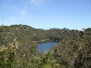
Lake Condah, also known by its Gunditjmara name Tae Rak, is in the Australian state of Victoria, about 324 kilometres (201 mi) west of Melbourne and 20 kilometres (12 mi) north-east of Heywood by road. It is in the form of a shallow basin, about 4 kilometres (2.5 mi) in length and 1 kilometre (0.62 mi) wide.

Budj Bim, also known as Mount Eccles, is an extinct volcano near Macarthur in southwestern Victoria, Australia. It lies within the geologically-defined area known as the Newer Volcanics Province, which stretches from western Victoria to south-eastern South Australia and the youngest volcanic area in Australia.
A Registered Aboriginal Party (RAP) is a recognised representative body of an Aboriginal Australian people per the Aboriginal Heritage Act 2006. These bodies act as the "primary guardians, keepers and knowledge holders of Aboriginal cultural heritage". They protect and manage the Aboriginal cultural heritage in Victoria, Australia.
The Aboriginal Heritage Act 2006 of the state of Victoria, Australia was enacted "to provide for the protection of Aboriginal cultural heritage in Victoria". It established Registered Aboriginal Parties to act as the "primary guardians, keepers and knowledge holders of Aboriginal cultural heritage". They protect and manage the Aboriginal cultural heritage in Victoria. The Act also established the Victorian Aboriginal Heritage Council and the Victorian Aboriginal Heritage Register, gave powers for Authorised Officers and Aboriginal Heritage Officers, and laid out Cultural Heritage Management Plans (CHMPs) and Cultural Heritage Permit processes, to manage activities that may impact Aboriginal cultural heritage.

Docker is a town in Victoria, Australia. It is located on Wangaratta-Whitfield Road along the King River. At the 2016 census, Docker recorded a population of 120.
Budj Bim heritage areas include the Budj Bim National Heritage Landscape, which was added to the National Heritage List on 20 July 2004, and the Budj Bim Cultural Landscape, which was designated a UNESCO World Heritage Site on 6 July 2019. Within the Budj Bim Cultural Landscape, there are three Indigenous Protected Areas: the Tyrendarra Indigenous Protected Area, Kurtonitj Indigenous Protected Area (2009) and the Lake Condah Indigenous Protected Area (2010).
Lake Condah Mission, also known as Condah Mission, was established in 1867 as a Church of England mission, approximately 3 kilometres (1.9 mi) from Lake Condah, which was traditionally known as Tae Rak, and about 20 kilometres (12 mi) to 25 kilometres (16 mi) south-east of the small town of Condah. The site of the mission, on 2,000 acres (810 ha) north of Darlot Creek, was formally reserved in 1869, and the Mission continued operations until the reserve was finally revoked in 1951, with most of the land handed over to the Soldiers Settlement Scheme to provide land for white veterans of World War II.