Related Research Articles
Geelong is a port city in the southeastern Australian state of Victoria, located at the eastern end of Corio Bay and the left bank of Barwon River, about 65 km (40 mi) southwest of Melbourne, the state capital of Victoria.
The City of Hobsons Bay is a local government area in Melbourne, Victoria, Australia. It comprises the south-western suburbs between 6 and 20 km from the Melbourne city centre.

The City of Greater Geelong is a local government area in the Barwon South West region of Victoria, Australia, located in the western part of the state. It covers an area of 1,248 square kilometres (482 sq mi) and, had a population of 271,057 as of the 2021 Australian census. It is primarily urban with the vast majority of its population living in the Greater Geelong urban area, while other significant settlements within the LGA include Anakie, Balliang, Barwon Heads, Batesford, Ceres, Clifton Springs, Drysdale, Lara, Ocean Grove, Portarlington and St Leonards. It was formed in 1993 from the amalgamation of the Rural City of Bellarine, Shire of Corio, City of Geelong, City of Geelong West, City of Newtown, City of South Barwon, and parts of Shire of Barrabool and Shire of Bannockburn.

North Melbourne is an inner-city suburb in Melbourne, Victoria, Australia, 3 km (1.9 mi) north-west of Melbourne's Central Business District, located within the City of Melbourne local government area. North Melbourne recorded a population of 14,953 at the 2021 census.

Werribee is a suburb in Melbourne, Victoria, Australia, 32 km (20 mi) south-west of Melbourne's Central Business District, located within the City of Wyndham local government area. Werribee recorded a population of 50,027 at the 2021 census.

Torquay is a seaside resort in Victoria, Australia, which faces Bass Strait, 21 km south of Geelong and is the gateway to the Great Ocean Road. It is bordered on the west by Spring Creek and its coastal features include Point Danger and Zeally Bay. At the 2021 census, Torquay had a population of 18,534.

North Hobart is a suburb of the city of Hobart, Tasmania, Australia. As its name suggests, it lies directly north of the CBD.

Yarraville is an inner-city suburb in Melbourne, Victoria, Australia, 6 km (3.7 mi) west of Melbourne's Central Business District, located within the City of Maribyrnong local government area. Yarraville recorded a population of 15,636 at the 2021 census.

North Geelong is a suburb of Geelong in the Australian state of Victoria. The suburb was bypassed by traffic from Melbourne coming from the Princes Freeway by the creation of the Geelong Ring Road, which was complete in 2009. At the 2016 census, North Geelong had a population of 2,966.

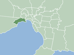
Geelong West is a commercial and residential suburb of Geelong, Victoria, Australia. When Geelong was founded, the area was known as Kildare but its name was changed to Geelong West in 1875. The main street is Pakington Street. At the 2016 census, Geelong West had a population of 6,966.
Newcomb is a residential suburb of Geelong, Victoria, Australia. At the 2016 census, Newcomb had a population of 4,500.

Anglesea is a town in Victoria, Australia. It is located on the Great Ocean Road in the Surf Coast Shire local government area. In the 2016 census, Anglesea had a population of 2,545 people.
Pako Festa is an annual festival held in Pakington Street, Geelong West each year around late February. The festival is held to promote cultural diversity and show appreciation for the artwork and fashion designed by citizens of the Geelong area.
West Footscray is an inner-city suburb in Melbourne, Victoria, Australia, 8 km (5.0 mi) west of Melbourne's Central Business District, located within the City of Maribyrnong local government area. West Footscray recorded a population of 11,729 at the 2021 census.

The Ford Discovery Centre was an interactive automobile museum located in Geelong, Victoria, Australia. It was operated by Ford Heritage Ltd, a Not for Profit Trust set up to showcase and preserve the heritage of the Ford Motor Company in Australia.
The Skeleton Creek Trail is a shared use path for cyclists and pedestrians, which follows Skeleton Creek as it passes through the outer south western suburbs of Point Cook and Altona Meadows in Melbourne, Victoria, Australia.
The Northern Pipe Trail, is a shared-use path for cyclists and pedestrians that follows Cheddar and St Georges roads in the northern suburbs of Reservoir, Preston and Thornbury in Melbourne, Victoria, Australia.

The Geelong Waterfront is a tourist and recreation area on the north facing shores of Corio Bay in Geelong, Australia. The area was once part of the Port of Geelong, falling into disuse before being redeveloped during the 1990s.

The City of Geelong West was a local government area about 5 kilometres (3 mi) west of the regional city of Geelong, Victoria, Australia. The city covered an area of 5.26 square kilometres (2.0 sq mi), and existed from 1875 until 1993.
The City of Newtown was a local government area about 3 kilometres (1.9 mi) west of the regional city of Geelong, Victoria, Australia. The city covered an area of 6.22 square kilometres (2.4 sq mi), and existed from 1858 until 1993.
References
- ↑ Pakington Street, Geelong
- ↑ "Little Pakington leasing open and set to bring a laneway culture to Geelong West - realestate.com.au". realestate.com.au. 15 February 2017. Retrieved 7 May 2017.
- ↑ "Pakington Street - Intown Geelong". www.intown.com.au. Retrieved 8 May 2017.