
Ballarat is a city in the Central Highlands of Victoria, Australia. Ballarat has a population of 117,240, making it the third largest city in Victoria.

Deer Park is a suburb in Melbourne, Victoria, Australia, 17 km (11 mi) west of the Melbourne central business district, located within the City of Brimbank local government area. Deer Park recorded a population of 18,145 at the 2021 census.

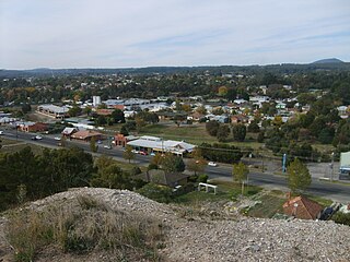
Ballarat North is a suburb of Ballarat, Victoria, Australia located north of Ballarat's central area. Ballarat North is bounded by Norman Street; Ballarat General Cemetery and Western Freeway to the north, Howitt Street to the south, Doodts Road to the east and the Mildura railway line to the west. At the 2021 census, Ballarat North had a population of 4,041.

Alfredton is a suburb of Ballarat, Victoria, Australia, west of the CBD. The population at the 2021 census was 11,822 making it the most populated in the Ballarat urban area.

Caulfield North is an inner suburb in Melbourne, Victoria, Australia, 8 km south-east of Melbourne's Central Business District, located within the City of Glen Eira local government area. Caulfield North recorded a population of 16,903 at the 2021 census.

Ballarat East is a suburb of Ballarat in Victoria, Australia. From 1857 until 1921 the suburb had its own council. The suburb covers a large area east of the city centre. It is the oldest urban area in Ballarat and was the site of many goldmines, as well as of the Eureka Rebellion.
Glenelg Highway is a rural highway in south-eastern Australia, linking Mount Gambier with Ballarat. Most of the highway is located within the Western part of the state of Victoria, though a short, 15 km stretch from the South Australia/Victoria state border near Ardno to Glenburnie is located in South Australia. Some maps identify the South Australian stretch as Casterton Road. Major towns along its route include Casterton, Coleraine and Hamilton.

Lake Gardens is a relatively new suburb on the western rural-urban fringe of Ballarat, Victoria Australia located near Lake Wendouree and directly behind the Ballarat Botanical Gardens from which the suburb draws its name. The suburb is bounded by Gillies Street to the east, O'Donnell's Road to the west and Gregory Street West to the north. The population at the 2021 census was 1,801.
Wendouree is a large suburb on the north western rural-urban fringe of the city of Ballarat, in Victoria, Australia. It is the second most populated suburb in the City of Ballarat with a total of 10,376 inhabitants at the 2021 census.

Sebastopol is a southern suburb on the rural-urban fringe of Ballarat, Victoria, Australia. It is the third most populated area in urban Ballarat with a population of 10,194 at the 2021 census.
Canadian is a residential suburb in Ballarat, Victoria, located 3km south-east of Ballarat Central. At the 2021 census, Canadian had a population of 4,098.

Soldiers Hill is a suburb of Ballarat, Victoria, Australia located directly north of the Central Business District. At the 2021 census, Soldiers Hill had a population of 2,813.

Bakery Hill is an inner city suburb of Ballarat in Victoria, Australia. It is the smallest suburb in the city of Ballarat in terms of both area and population, which at the 2021 census was just 180 people. The area is a mix of residential and commercial, as it has been since it came into existence at the beginning of the gold rush. In the present time it is mainly known for its restaurants and pubs, as well as fast food. The suburb boundaries are that of Mair, East, Barkly, Steinfield and Peel Streets.
Eureka is a small eastern suburb of Ballarat, Victoria, Australia – (AU). It was originally part of Ballarat East but became its own suburb in 1946 in recognition of the area's significance to Australian history. Eureka is bordered by Specimen Creek to the north, Canadian Creek to the south, Queen and Joseph streets to the west and Kline and Stawell Street to the east. The suburb takes its name from the Eureka Lead – a lead is an ancient river bed that contains gold – of the Eureka Mining Company and is most notable as the site of the historic event of the Eureka Rebellion. This was the site where the rebel miners flew the Eureka Flag for the first time; a flag that has since become a symbol of the working class and trade union movement and, at times, Australian republicanism.
Warrenheip is a suburb of Ballarat, Victoria, Australia on the eastern rural-urban fringe named after nearby Mount Warrenheip. At the 2021 census, Warrenheip had a population of 721.
Delacombe is a large and rapidly growing industrial/residential suburb on the south west rural-urban fringe of Ballarat, Victoria, Australia. The population at the 2021 census was 5,408 making it the fifth most populated in the Ballarat urban area.
Cardigan is a suburb on the north-western rural-urban fringe of Ballarat in Victoria, Australia. At the 2021 census, Cardigan had a population of 1,064.
Bonshaw is a locality on the southern rural fringe of the City of Ballarat in Victoria, Australia. At the 2021 census, Bonshaw had a population of 949. This is an increase from a population of 210 at the 2016 census and 188 at the 2011 census.
Cardigan Village is a town on the north-western rural-urban fringe of Ballarat in Victoria, Australia. At the 2021 census, Cardigan had a population of 957. It was named after James Brudenell, 7th Earl of Cardigan, who led the Charge of the Light Brigade at the Battle of Balaclava during the Crimean War. It is recorded as having a school in 1860, 1903, and 1960; and in 1903 also had a Presbyterian church, a post office, and a hotel.
Winter Valley is a western suburb of the City of Ballarat. The population at the 2021 census was 3,440. Established on 11 February 2016 as part of the western growth zone, Winter Valley was named after early colonist John Winter following a controversy on whether on not it should be named after the 19th-century Aboriginal elder Mullawallah.


