Ballarat is a city in the Central Highlands of Victoria, Australia. Ballarat has a population of 119,096 as of March 2024 making it the third-largest urban inland city in Australia and the third-largest city in Victoria.

The Eureka Rebellion was a series of events involving gold miners who revolted against the British administration of the colony of Victoria, Australia during the Victorian gold rush. It culminated in the Battle of the Eureka Stockade, which took place on 3 December 1854 at Ballarat between the rebels and the colonial forces of Australia. The fighting left at least 27 dead and many injured, most of the casualties being rebels. There was a preceding period beginning in 1851 of peaceful demonstrations and civil disobedience on the Victorian goldfields. The miners, many of whom such as Raffaello Carboni came from Europe and were veterans of the Revolutions of 1848, had various grievances, chiefly the cost of mining permits and the officious way the system was enforced.
The Victorian gold rush was a period in the history of Victoria, Australia, approximately between 1851 and the late 1860s. It led to a period of extreme prosperity for the Australian colony and an influx of population growth and financial capital for Melbourne, which was dubbed "Marvellous Melbourne" as a result of the procurement of wealth.

Braybrook is a suburb in Melbourne, Victoria, Australia, 10 km (6.2 mi) west of Melbourne's Central Business District, located within the City of Maribyrnong local government area. Braybrook recorded a population of 9,682 at the 2021 census.

Sovereign Hill is an open-air museum in Golden Point, a suburb of Ballarat, Victoria, Australia. Sovereign Hill depicts Ballarat's first ten years after the discovery of gold there in 1851 and has become a nationally acclaimed tourist attraction. It is one of Victoria's most popular attractions and Ballarat's most famous.

Peter Fintan Lalor was an Irish-Australian rebel and, later, politician who rose to fame for his leading role in the Eureka Rebellion, an event identified with the "birth of democracy" in Australia.
John Basson Humffray was a leading advocate in the movement of miner reform process in the British colony of Victoria, and later a member of parliament.

Lethbridge is a rural township outside Geelong, Victoria, Australia. Bluestone from Lethbridge quarries was used to build several significant buildings in Melbourne, including the steps to the Parliament House. At the 2016 census, Lethbridge had a population of 1,014.

Melbourne is Australia's second largest city and widely considered to be a garden city, with Victoria being nicknamed "the Garden State". Renowned as one of the most livable cities in the world, there is an abundance of parks, gardens and green belts close to the CBD with a variety of common and rare plant species amid landscaped vistas, pedestrian pathways, and tree-lined avenues, all managed by Parks Victoria.

Black Hill is a suburb of Ballarat, Victoria, Australia in the northeast of the city. It is named after the major landmark, Black Hill, on which there was extensive and highly profitable open-cut gold mining from the early 1850s during the Victoria gold rush. The hill was originally given its indigenous name, Bowdun, by surveyor William Urquhart.

Gordon is a small town in Victoria, Australia, named after settler George Gordon. The town is located on the Old Melbourne Road in the Shire of Moorabool local government area, 95 kilometres (59 mi) west of the state capital, Melbourne. At the 2021 census, Gordon had a population of 1,393.
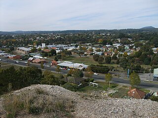
Canadian is a residential suburb in Ballarat, Victoria, located 3km south-east of Ballarat Central. At the 2021 census, Canadian had a population of 4,098.

Soldiers Hill is a suburb of Ballarat, Victoria, Australia located directly north of the Central Business District. At the 2021 census, Soldiers Hill had a population of 2,813.

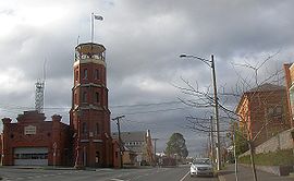
Ballarat Central is the central locality of Greater Ballarat in Victoria, Australia. The population of Ballarat Central at the 2021 census was 5,378, making it the sixth most populous in the urban area. It is the administrative headquarters for the City of Ballarat as well as the Ballarat Base Hospital and health services and home to the city's major religious institutions and a major retail, commercial and inner city residential area.

Bakery Hill is an inner city suburb of Ballarat in Victoria, Australia. It is the smallest suburb in the city of Ballarat in terms of both area and population, which at the 2021 census was just 180 people. The area is a mix of residential and commercial, as it has been since it came into existence at the beginning of the gold rush. In the present time it is mainly known for its restaurants and pubs, as well as fast food. The suburb boundaries are that of Mair, East, Barkly, Steinfield and Peel Streets.

Golden Point is a suburb of Ballarat, Victoria, Australia located south-east of the CBD. It is the oldest settlement in Greater Ballarat. Gold was discovered at Poverty Point on 21 August 1851 by John Dunlop and James Regan, sparking the Ballarat gold rush. Golden Point was the site of what was known as the Ballarat diggings, and for at least a decade the focal point of the original Ballarat township was Main Street. At the 2021 census, Golden Point had a population of 2,217.

Mount Pleasant is the oldest residential suburb of Ballarat, Victoria, Australia. It is located on the southern extremity of the city between the Yarrowee Creek and the White Horse Range. Physically it is largely cut off from the rest of Ballarat which contributes to a sense of a suburb apart. The traditional Wathaurung country was first settled in 1836 when the Yuille brothers established a sheep run that included the sheltered corner under the escarpment later named Mount Pleasant. In those days, before there was a town at Ballarat, Buninyong was the nearest township. When the gold rush of 1851 brought thousands of diggers to nearby Golden Point, Mount Pleasant was left alone as no gold was initially found there. Its peacefulness made it attractive to a number of Cornish miners and their families who had come to Australia to settle permanently. These Wesleyans were the founders of the community. As devout and sober church people they sought a place to live away from the drunken mayhem of the diggings around Main Road.
Eureka is a small eastern suburb of Ballarat, Victoria, Australia. It was originally part of Ballarat East but became its own suburb in 1946 in recognition of the area's significance to Australian history. Eureka is bordered by Specimen Creek to the north, Canadian Creek to the south, Queen and Joseph streets to the west and Kline and Stawell Street to the east. The suburb takes its name from the Eureka Lead – a lead is an ancient river bed that contains gold – of the Eureka Mining Company and is most notable as the site of the historic event of the Eureka Rebellion. This was the site where the rebel miners flew the Eureka Flag for the first time; a flag that has since become a symbol of the working class and trade union movement and, at times, Australian republicanism.

The Yarrowee River is a perennial river of the Corangamite catchment, located in the Central Highlands region of the Australian state of Victoria.
The Eureka Stockade Memorial Park is believed to encompass the site of the Battle of the Eureka Stockade that was fought in Ballarat on 3 December 1854. Records of "Eureka Day" ceremonies at the site of the battle go back to 1855. In addition to the Eureka Stockade Monument, there are other points of interest in the reserve, including the Eureka Stockade Gardens and an interpretative centre. There was formerly a swimming pool and other structures. There has been a nearby caravan park since the 1950s. The present Eureka Stockade Memorial Park Committee has undergone several name changes since 1922.