Holsworthy is a suburb in south-western Sydney, in the state of New South Wales, Australia 31 kilometres south-west of the Sydney central business district, in the local government area of the City of Liverpool.

Ultimo is an inner-city suburb of Sydney, New South Wales, Australia. It is adjacent to the Sydney central business district in the local government area of the City of Sydney west of the Darling Harbour area, and is bordered by Pyrmont to the north, the Sydney CBD and Chinatown/Haymarket to the east, Broadway and Chippendale to the south, and Glebe and Wentworth Park to the west.

Wattle Range Council is a local government area in the Limestone Coast region of South Australia. It stretches from the coast at Beachport east to the Victorian border. It had a population of over 11,000 as at the 2016 Census.

Woolooware is a suburb in southern Sydney, in the state of New South Wales, Australia. Woolooware is located 24 kilometres (15 mi) south of the Sydney central business district in the Sutherland Shire. It shares the 2230 postcode with Cronulla.
Wattle Grove is a suburb of Sydney, in the state of New South Wales, Australia. Wattle Grove is located 30 kilometres south-west of the Sydney central business district in the local government area of the City of Liverpool.
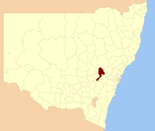
Bathurst Regional Council is a local government area in the Central West region of New South Wales, Australia. The area is located adjacent to the Great Western Highway, Mid-Western Highway, Mitchell Highway and the Main Western railway line. At the 2021 census, the Bathurst Region had a population of 43,567.

The District Council of Grant is a local government area located in the Limestone Coast region of South Australia, and is the southernmost council in the state.

Colo Vale is a Northern Village of the Southern Highlands of New South Wales, Australia, in Wingecarribee Shire. Colo Vale is approximately 100 km south west on the Hume Highway from Sydney. It is situated 2 km north-west of Aylmerton, 5 km from the Hume Highway and 12 km drive to Mittagong. The surrounding area is part of the Parish of Colo which includes the villages of Aylmerton, Willow Vale, Alpine and Yerrinbool. Colo Vale has a mixed-business general store and many home-based businesses, including hairdressers, small manufacturing businesses and a large native plant nursery and a Public School on Wattle Street. A large sporting oval is located adjacent to the school with tennis courts, a community hall and a Rural Fire Service station.
Wattle Ridge is a locality in the Southern Highlands of New South Wales, Australia, in Wingecarribee Shire. It is located near Buxton and Balmoral.

Wattle and daub is a composite building method used for making walls and buildings, in which a woven lattice of wooden strips called "wattle" is "daubed" with a sticky material usually made of some combination of wet soil, clay, sand, animal dung and straw. Wattle and daub has been used for at least 6,000 years and is still an important construction method in many parts of the world. Many historic buildings include wattle and daub construction.
Nangwarry is a town and a locality in the Australian state of South Australia located about 352 kilometres (219 mi) south-east of the state capital of Adelaide and about 32 kilometres (20 mi) north-west of the regional centre of Mount Gambier.

Bool Lagoon is a locality in the Australian state of South Australia located in the south-east of the state in the Limestone Coast region about 311 kilometres south east of the state capital of Adelaide.
Nora Creina is a locality in the Australian state of South Australia located on the state’s south-east coast overlooking the Southern Ocean. It is about 99 kilometres to the north-west of the city of Mount Gambier and about 290 kilometres south-east of the state capital of Adelaide.
Wattle Camp is a rural locality in the South Burnett Region, Queensland, Australia. In the 2016 census Wattle Camp had a population of 517 people.
Wattle Grove is a rural locality in the South Burnett Region, Queensland, Australia. In the 2016 census Wattle Grove had a population of 86 people.
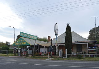
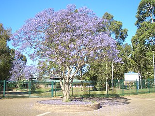
Wattle Flat is a locality in the Bathurst Region of New South Wales, Australia. It had a population of 257 people as of the 2016 census. There is a small village of the same name, near the confluence of Big Oaky Creek and its tributary Solitary Creek.

Wattle Flat is a locality in the Australian state of South Australia located on the Fleurieu Peninsula. At the 2016 census, Wattle Flat had a population of 164.
Wattle Bank is a locality located in Bass Coast Shire in Victoria, Australia.
Bulli Creek is a locality in the Toowoomba Region, Queensland, Australia. In the 2016 census, Bulli Creek had a population of 6 people.
Wattle Ridge is a locality in the Toowoomba Region, Queensland, Australia. In the 2016 census, Wattle Ridge had a population of 36 people.
