Franklinford, Victoria

Last updated

Franklinford
Victoria
FranklinfordMonument.JPG
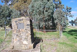
Monument at Franklinford. It reads "Edward Stone Parker 1802 - 1865 Regional Pioneer Protector of Aboriginies established the Loddon Aboriginal Station, Homestead, Church and School near this site in 1841. His devoted service remains a challenge and inspiration. April 1966."
Australia Victoria Hepburn Shire location map.svg
Red pog.svg
Franklinford
Coordinates 37°14′15″S144°5′33″E / 37.23750°S 144.09250°E / -37.23750; 144.09250
Population66 (2016 census) [1]
Postcode(s) 3461 [2]
Location100 km (62 mi) NW of Melbourne
LGA(s) Shire of Hepburn

Franklinford is a locality in the Central Highlands of Victoria, Australia, located in the Shire of Hepburn.

Contents

It was the site chosen by Edward Stone Parker to build the Loddon Aboriginal Protectorate station at Franklinford in January 1841 which was an important focus of the Dja Dja Wurrung people from 1841 until they were forcibly resettled in 1864. [3] It is located on the Midland Highway.

At the 2016 census, Franklinford had a population of 66 people. [4]

There is no longer any general store or hotel in the town; the nearest being at Newstead, Hepburn or Daylesford.

History

Loddon Aboriginal Protectorate Station

Mount Franklin was the territory of the Gunangara Gundidj clan of the Dja Dja Wurrung. [5] Ethnographical and archaeological evidence indicates that frequent large ceremonial gatherings took place in the area. [6]

Aboriginal farmers at the Loddon Aboriginal Protectorate at Franklinford, 1858 Aboriginal farmers at Franklinford 1858.jpg
Aboriginal farmers at the Loddon Aboriginal Protectorate at Franklinford, 1858

In January 1841 Parker selected a site on the northern side of Mount Franklin on Jim Crow Creek with permanent spring water. The site was chosen with the support of The Dja Dja Wurrung as well as Crown Lands Commissioner Frederick Powlett. Approval for the site was given in March, and a large number of Dja Dja Wurrung accompanied Parker there in June 1841 when the station was established on William Mollison's Coliban run, where an outstation hut already existed. [7] This became known as the Loddon Aboriginal Protectorate Station at Franklinford, and the area was known to the Dja Dja Wurrung as Larne-ne-barramul or the habitat of the emu. Nearby Mount Franklin was known as Lalgambook. [8]

A Homestead, church, school and several out buildings were initially constructed. The first teacher at the school was Charles Judkins, [9] who died at the station aged 42. [10] Franklinford provided a very important focus for the Dja Dja Wurrung during the 1840s where they received a measure of protection and rations, but they continued with their traditional cultural practices and semi-nomadic lifestyle as much as they could. At times over 200 aborigines congregated at Franklinford. [11]

The protectorate ended on 31 December 1848, with about 20 or 30 Dja Dja Wurrung living at the station at that time. Parker and his family remained living at Franklinford. Six Dja Dja Wurrung men and their families settled at Franklinford, but all but one died from misadventure or respiratory disease. Tommy Farmer was the last survivor of this group who walked off the land in 1864 and joined the Coranderrk reserve. [12]

The Aboriginal Protectorate school at Franklinford was closed in February 1864, with the children and families forcibly resettled at Coranderrk Reserve.

On 26 May 2004 Susan Rankin, a Dja Dja Wurrung elder, peacefully reoccupied crown land at Franklinford in central Victoria, calling her campsite the Going Home Camp. Rankin asked the Victorian Department of Sustainability and Environment to produce documents proving that the Crown has the right to occupy these lands. According to the 2 June 2004 Daylesford Advocate, local DSE officers admitted they "cannot produce these documents and doubt that such documents exist". [13] [14]

Franklinford Common School

Franklinford Common School was built in the mid-1860s, with the Franklinford Hall listed on the Victorian Heritage list, as one of the few schools of its kind still surviving in its original rural setting. The hall received funding for essential repairs and maintenance from the Victorian State Government in December 2008. [15]

Franklinford Post Office opened on 15 February 1859 and closed in 1969. [16]

Related Research Articles

<span class="mw-page-title-main">Shire of Hepburn</span> Local government area in Victoria, Australia

The Shire of Hepburn is a local government area in Victoria, Australia, located in the central part of the state. It covers an area of 1,473 square kilometres (569 sq mi) and, in the 2021 Census the shire had a population of 16,604.

<span class="mw-page-title-main">Shire of Loddon</span> Local government area in Victoria, Australia

The Shire of Loddon is a local government area in Victoria, Australia, located in the northern part of the state. It covers an area of 6,696 square kilometres (2,585 sq mi) and in 2021 had a population of 7,759.

<span class="mw-page-title-main">Waterloo Creek massacre</span> Massacre of Australian Gamilaraay peoples 1837–1838

The Waterloo Creek massacre refers to a series of violent clashes between mounted police, civilian vigilantes and Indigenous Gamilaraay peoples, which occurred southwest of Moree, New South Wales, Australia, during December 1837 and January 1838. The Waterloo Creek Massacre site is listed on the New South Wales Heritage Register as a place of significance in frontier violence leading to the murder of Gamilaraay people. The events have been subject to much dispute, due to wildly conflicting accounts by various participants and in subsequent reports and historical analyses, about the nature and number of fatalities and the lawfulness of the actions. Interpretation of the events at Waterloo Creek was raised again during the controversial "history wars" which began in the 1990s in Australia.

<span class="mw-page-title-main">Daylesford, Victoria</span> Town in Victoria, Australia

Daylesford is a spa town located in the foothills of the Great Dividing Range, within the Shire of Hepburn, Victoria, Australia, approximately 114 kilometres north-west of Melbourne. First established in 1852 as a gold-mining town, today Daylesford has a population of 2,781 as of the 2021 census.

<span class="mw-page-title-main">Taungurung</span>

The Taungurung people, also spelt Daung Wurrung, are an Aboriginal people who are one of the Kulin nations in present-day Victoria, Australia. They consist of nine clans whose traditional language is the Taungurung language.

<span class="mw-page-title-main">Campbells Creek, Victoria</span> Town in Victoria, Australia

Campbells Creek is a town in Victoria, Australia.

<span class="mw-page-title-main">Djadjawurrung</span> Aboriginal Australian people in Victoria

Dja Dja Wurrung, also known as the Djaara or Jajowrong people and Loddon River tribe, are an Aboriginal Australian people who claim they were the traditional owners of lands including the watersheds of the Loddon and Avoca rivers in the Bendigo region of central Victoria, Australia. They are part of the Kulin alliance of Aboriginal Victorian peoples. There are 16 clans, which adhere to a patrilineal system. Like other Kulin peoples, there are two moieties: Bunjil the eagle and Waa the crow.

<span class="mw-page-title-main">Wurundjeri Woi Wurrung Cultural Heritage Aboriginal Corporation</span> Registered Aboriginal Party representing the Wurundjeri people in Victoria, Australia

The Wurundjeri Woi Wurrung Cultural Heritage Aboriginal Corporation, previously the Wurundjeri Tribe Land and Compensation Cultural Heritage Council, is a Registered Aboriginal Party representing the Wurundjeri people, an Aboriginal Australian people of Victoria.

Munangabum was an influential clan head of the Liarga balug and Spiritual Leader or neyerneyemeet of the Dja Dja Wurrung people in central Victoria, Australia.

The Blood Hole massacre occurred in what is now the Australian state of Victoria at Middle Creek, 10–11 kilometres (6–7 mi) from Glengower Station between Clunes and Newstead at the end of 1839 or early 1840, killing an unknown number of Aboriginals from the Grampians district who were on their way home after trading goods for green stone axe blanks that they obtained near what is now Lancefield.

<span class="mw-page-title-main">Aboriginal tracker</span>

Aboriginal trackers were enlisted by Europeans in the years following British colonisation of Australia, to assist them in exploring the Australian landscape. The excellent tracking skills of these Aboriginal Australians were advantageous to settlers in finding food and water and locating missing persons, capturing bushrangers and dispersing other groups of Indigenous peoples.

The Campaspe Plains massacre in 1839 in Central Victoria, Australia was as a reprisal raid against Aboriginal resistance to the invasion and occupation of the Dja Dja Wurrung and Taungurung lands. Charles Hutton took over the Campaspe run, located near the border of Dja Dja Wurrung and Taungurung, in 1838 following sporadic confrontations.

<span class="mw-page-title-main">Edward Stone Parker</span> Australian Methodist preacher and assistant Protector of Aborigines

Edward Stone Parker (1802–1865) was a Methodist preacher and assistant Protector of Aborigines in the Aboriginal Protectorate established in the Port Phillip District of colonial New South Wales under George Augustus Robinson in 1838. He established and administered the Franklinford Aboriginal Protectorate Station in the territory of the Dja Dja Wurrung people from January 1841 to the end of 1848.

Thomas Dunolly (1856–1923) was an early Indigenous Australian rights activist. He was a member of the Dja Dja Wurrung people. The surname Dunolly is the name of the township where he was born.

<span class="mw-page-title-main">Susan Charles Rankin</span> Australian Indigenous activist

Susan Charles Rankin, also known as Aunty Sue Rankin, is an Australian Indigenous rights and human rights activist and Elder of the Dja Dja Wurrung people of the Kulin nation from Central Victoria, Australia. She was one of five signatories by Australian Aboriginal elders who lodged a writ in the High Court of Australia in April 2005 calling for the Australian Federal Government to be investigated for crimes of genocide.

<span class="mw-page-title-main">Jim Crow goldfield</span> Nineteenth-century gold mine in Victoria, Australia

The Jim Crow goldfield was part of the Goldfields region of Victoria, Australia, where gold was mined from the mid- to the late-nineteenth century.

<span class="mw-page-title-main">Mount Franklin (Victoria)</span> Mountain in Victoria, Australia

Mount Franklin is an extinct volcano about 10 km north of Daylesford and 4.6 km south east of Franklinford in Victoria, Australia. A road spirals round the outside slopes covered with pine trees, into a flat 50 acre caldera, now used as a camping ground, and onto the rim which hosts a fire lookout, parking area and picnic ground.

<span class="mw-page-title-main">John Hunter Kerr</span>

John Hunter Kerr (1820–1874) was a Scottish-born grazier, amateur photographer and collector of Indigenous artefacts in Victoria, Australia, during the mid-nineteenth century. He was the fourth son of Captain A R. Kerr, R.N., C B, and brother of Vice-Admiral R. Kerr.

An Aboriginal reserve, also called simply reserve, was a government-sanctioned settlement for Aboriginal Australians, created under various state and federal legislation. Along with missions and other institutions, they were used from the 19th century to the 1960s to keep Aboriginal people separate from the white Australian population, for various reasons perceived by the government of the day. The Aboriginal reserve laws gave governments much power over all aspects of Aboriginal people’s lives.

Strangways is a locality within the local government area of Mount Alexander, in Central Victoria, Australia. It covers an area of 20.105 square kilometres between the townships of Guidford to the east, Newstead to the north-west and Clydesdale to the south.

References

  1. "2016 Census QuickStats: Franklinford".
  2. Postcodes - Victorian Postal Codes, 3381 to 3663, Melbourne Victoria Postcodes Archived 3 May 2008 at the Wayback Machine . Postcodes.com.au. Retrieved 2008-12-25.
  3. Bain Attwood, My Country. A history of the Djadja Wurrung 1837-1864, Monash Publications in History:25, 1999, ISSN   0818-0032
  4. Australian Bureau of Statistics (27 June 2017). "Franklinford". 2016 Census QuickStats. Retrieved 19 July 2017. OOjs UI icon edit-ltr-progressive.svg
  5. MacDonald, Janet; Garry Powell (2008). Double Gold: 1870s Mining and Farming Diaries. Windsor, Victoria: Prahran Mechanics Institute Press. ISBN   978-0-9804536-2-1.
  6. Daniel Catrice, Victoria's Heritage. Mount Franklin, Hepburn Regional Park Archived 20 July 2008 at the Wayback Machine , Parks Victoria, 1995. Accessed 25 December 2008
  7. Parker Quarterly report 1 June - 31 Aug 1841, PROVic, VPRS 10/3, file 41/207 as referenced by Bain Attwood, pp26, My Country. A history of the Djadja Wurrung 1837-1864, Monash Publications in History:25, 1999, ISSN   0818-0032
  8. Edgar Morrison, Frontier life in the Loddon Protectorate : episodes from early days, 1837-1842, Daylesford [Vic.], The Advocate, 1967?. No ISBN
  9. "THE CALL TO AUSTRALIA | Seamons Family History". 27 December 2018. Archived from the original on 27 December 2018. Retrieved 27 December 2018.
  10. "Family Notices". Argus (Melbourne, Vic. : 1848 - 1957). 16 September 1864. p. 4. Retrieved 27 December 2018.
  11. Bain Attwood, pp23-36, My Country. A history of the Djadja Wurrung 1837-1864, Monash Publications in History:25, 1999, ISSN   0818-0032
  12. Richard Broome, pp115, Aboriginal Victorians. A History since 1800, Allen & Unwin, 2005, ISBN   1-74114-569-4
  13. Margaret Murphy, `Sovereignty, not sorry' Archived 27 September 2008 at the Wayback Machine , Green Left Weekly, 7 July 2004. Accessed 25 December 2008
  14. Jaara re-occupation and camp Archived 6 October 2008 at the Wayback Machine , Melbourne Indymedia, 4 June 2004. Accessed 25 December 2008
  15. Madeleine Jenkins, Restoration grant for Franklinford Hall Archived 11 July 2012 at archive.today , Hepburn Advocate, 16 December 2008. Accessed 25 December 2008
  16. Premier Postal History. "Post Office List" . Retrieved 11 April 2008.