Ballarat Central

Last updated

Ballarat Central
Ballarat,  Victoria
Aerialviewgardens.jpg
Looking east over Sturt Street and the CBD toward Bridge Mall and Bakery Hill from Ballarat Town Hall clock tower
Australia Victoria Ballarat City location map.svg
Red pog.svg
Ballarat Central
Coordinates 37°33′47″S143°51′04″E / 37.563°S 143.851°E / -37.563; 143.851 Coordinates: 37°33′47″S143°51′04″E / 37.563°S 143.851°E / -37.563; 143.851
Population5,328 (2016 census) [1]
 • Density1,440/km2 (3,730/sq mi)
Postcode(s) 3350
Area3.7 km2 (1.4 sq mi)
LGA(s) City of Ballarat
State electorate(s) Wendouree
Federal division(s) Ballarat
Suburbs around Ballarat Central:
Lake Wendouree Soldiers Hill Ballarat East
Lake Wendouree Ballarat Central Bakery Hill
Newington, Redan Redan, Golden Point Golden Point

Ballarat Central (known as the Central Business Area by the City of Ballarat and sometimes simply as "Ballarat") is the central locality of Greater Ballarat in Victoria, Australia. The population of Ballarat Central at the 2016 census was 5,328, [1] making it the third most populous in the urban area. It is the administrative headquarters for the City of Ballarat as well as the Ballarat Base Hospital and health services and home to the city's major religious institutions and a major retail, commercial and inner city residential area.

Contents

It is the third oldest settlement in Greater Ballarat (after the gold rush settlements of Ballarat East and Golden Point). Planned as a permanent settlement shortly following the initial gold rush, it was formerly known as Ballaarat West or the new township of Ballaarat.

The boundaries are Lexton, Drummond, Talbot and Pleasant Street to the west; Sebastopol, Hill, Hummfray and Steinford Street to the south; Peel Street to the east and Serviceton Railway Line to the north.

Ballarat Central is important historically to the development of the city as well as for its Victorian era architecture and much of its area is covered by Heritage Overlays.

History

Toponymy

While the original name for Ballarat Central was Ballaarat and later Ballarat West, the current name originates from the Central Division, a mining lead in the 1870s. Several sporting teams used the name, as well as the local primary school as early as the 1880s. It was officially gazetted "Ballarat Central" sometime after the 1980s although it is still marked simply "Ballarat" on some maps.

Settlement

The settlement of Ballarat West was established during the Victorian gold rush.

It was surveyed by William Urquhart as early as October 1851. [2] By 1852 his grid plan and wide streets were prepared for the first land sales in the new township of West Ballarat. [3]

As the city grew, Ballarat West became home to the city's middle class, bankers and wealthy professionals establishing businesses around Lydiard Street and institutions along Sturt and Drummond Streets.

Population

In the 2016 Census, there were 5,328 people in Ballarat Central. 82.0% of people were born in Australia and 86.3% of people only spoke English at home. The most common responses for religion were No Religion 40.1% and Catholic 24.8%. [1]

Urban form and planning

Sturt Street viewed from St. Peter's Anglican Church. The clock tower of the Ballarat Town Hall is also visible. View from St. Peter's Anglican Church, Ballarat.jpg
Sturt Street viewed from St. Peter's Anglican Church. The clock tower of the Ballarat Town Hall is also visible.
Ballarat Base Hospital's Henry Bolte Building is the tallest building in Ballarat Central BAllarat Hospital.jpg
Ballarat Base Hospital's Henry Bolte Building is the tallest building in Ballarat Central

Ballarat Central is laid out in grid plan. The tallest buildings in the central city area is the seven storey Henry Bolte wing of the Ballarat Base Hospital (erected 1994); the Law Court (now Arts Academy) tower (erected 1941) on Camp Street; Lydiard House on Lydiard Street Nth; and the MLC tower Lydiard Street Sth, (erected 1957) at five storeys. Planning approval was granted in 2010 for a six storey building on Mair Street.

The Ballarat City Council approved a Central Business District Strategy for the development of buildings, development sites, transport and streetscape for the next 20 – 25 years in late 2010. It aims to secure funding and private and government interest in the ongoing development of Ballarat's CBD. The draft proposal identifies Mair Street as an alternate East-West traffic route with the potential for hi-rise mixed use development and possibilities for the creation of a 'Civic Heart' for the city where public events can be conducted on a regular basis. [4]

Retail

Ballarat Central contains the main retail area of Ballarat, however in recent decades it has been challenged by Wendouree. Ballarat's main pedestrian mall is Bridge Mall which occupies a section of Bridge Street between Grenville Street and Humffray Street. The largest indoor shopping mall is Central Square Shopping Centre (built 1988) opposite the town hall which includes the major department stores of Myer and Target. Other shopping malls in the CBD include Norwich Plaza built in the 1970s and the City Arcade built in the 1980s. In the CBD there are several supermarkets including two Coles, a Woolworths, an Aldi and a Big W as well as large specialty stores including The Good Guys, JB Hi-Fi, Dick Smith Electronics and branches of the big four retail banks. Bridge Mall, Sturt Street, Armstrong and Mair Street are the major retail streets in the CBD.

Parks and open space

Sturt Street Gardens Ballarat Median Strip 001.JPG
Sturt Street Gardens

With the exception of Sturt Street Gardens, and small squares at Civic Hall, Camp Street, Bridge Mall and church grounds there is very little accessible recreational space in Ballarat Central.

There are just two sports ovals on the Western Oval on the western fringe and Hickman Street Oval on the southern fringe.

Transport

Modern fleet of VLocity railcars inside the train shed of Ballarat railway station. Vlocity railcars ballarat.jpg
Modern fleet of VLocity railcars inside the train shed of Ballarat railway station.

Several busy roads pass through Ballarat Central, they include Lydiard Street (north-south and the historic business street); Mair Street (east west - commercial and future business area); Sturt Street/Bridge Mall (east-west - main retail area); Armstrong Street (north-south); Doveton Street and Drummond Street (the hospital precinct). Car parking is a major problem in Ballarat Central, with restricted parking times (parking meters). While there are several parking lots, including a multi-storey facility on Dana Street owned by the council, parking spaces are heavily used. [5]

Ballarat is the hub of the Ballarat Transit bus network, with major terminals at Ballarat railway station and Little Bridge Street.

Ballarat railway station is the main railway station for Ballarat Central and also the urban area.

Related Research Articles

<span class="mw-page-title-main">Ballarat</span> Town in Victoria, Australia

Ballarat is a city in the Central Highlands of Victoria, Australia. At the 2021 Census, Ballarat had a population of 116,201, making it the third largest city in Victoria.

<span class="mw-page-title-main">Gosford</span> City in New South Wales, Australia

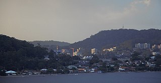
Gosford is the city and administrative centre of the Central Coast Council local government area in the heart of the Central Coast region, about 76 kilometres (47 mi) north of Sydney and about 91 kilometres (57 mi) south of Newcastle. The city centre is situated at the northern extremity of Brisbane Water, an extensive northern branch of the Hawkesbury River estuary and Broken Bay.

<span class="mw-page-title-main">Docklands, Victoria</span> Suburb of Melbourne, Victoria, Australia

Docklands is an inner-city suburb in Melbourne, Victoria, Australia, 2 km (1.2 mi) west of Melbourne's Central Business District, located within the City of Melbourne local government area. Docklands recorded a population of 15,495 at the 2021 census.

<span class="mw-page-title-main">Braybrook, Victoria</span> Suburb of Melbourne, Victoria, Australia

Braybrook is a suburb in Melbourne, Victoria, Australia, 10 km (6.2 mi) west of Melbourne's Central Business District, located within the City of Maribyrnong local government area. Braybrook recorded a population of 9,682 at the 2021 census.

<span class="mw-page-title-main">Oakleigh, Victoria</span> Suburb of Melbourne, Victoria, Australia

Oakleigh is a suburb in Melbourne, Victoria, Australia 14 km south-east of Melbourne's Central Business District, located within the City of Monash local government area. Oakleigh recorded a population of 8,442 at the 2021 census.

<span class="mw-page-title-main">Alfredton, Victoria</span> Suburb of Ballarat, Victoria, Australia

Alfredton is a suburb of Ballarat, Victoria, Australia, west of the CBD. The population at the 2016 census was 9,220 making it the third most populated in the Ballarat urban area.

<span class="mw-page-title-main">Murray Street, Perth</span> Street in CBD of Perth, Western Australia

Murray Street is one of four main east-west roads within the Perth central business district (CBD).

<span class="mw-page-title-main">Ballarat East, Victoria</span> Suburb of Ballarat, Victoria, Australia

Ballarat East is a suburb of Ballarat in Victoria, Australia. From 1857 until 1921 the suburb had its own council. The suburb covers a large area east of the city centre. It is the oldest urban area in Ballarat and was the site of many goldmines, as well as of the Eureka Rebellion.

<span class="mw-page-title-main">Brisbane central business district</span> Suburb of Brisbane, Queensland, Australia

Brisbane City is the central suburb and central business district of Brisbane, the state capital of Queensland, Australia. It is colloquially referred to as the "Brisbane CBD" or "the city". It is located on a point on the northern bank of the Brisbane River, historically known as Meanjin, Mianjin or Meeanjin in the local Aboriginal Australian dialect. The triangular shaped area is bounded by the median of the Brisbane River to the east, south and west. The point, known at its tip as Gardens Point, slopes upward to the north-west where the city is bounded by parkland and the inner city suburb of Spring Hill to the north. The CBD is bounded to the north-east by the suburb of Fortitude Valley. To the west the CBD is bounded by Petrie Terrace, which in 2010 was reinstated as a suburb.

<span class="mw-page-title-main">Ballarat railway station</span> Railway station in Victoria, Australia

Ballarat railway station is located on the Serviceton line in Victoria, Australia. It serves the city of Ballarat, and it opened on 11 April 1862 as Ballarat West. It was renamed Ballarat in 1865.

<span class="mw-page-title-main">Lake Wendouree, Victoria</span> Suburb of Ballarat, Victoria, Australia

Lake Wendouree is a suburb of Ballarat, Victoria, Australia located immediately west of the Ballarat central business district. It encompasses the man-made recreational lake Lake Wendouree, after which it is named. At the 2016 census, Lake Wendouree had a population of 2,882.

<span class="mw-page-title-main">Black Hill, Victoria</span> Suburb of Ballarat, Victoria, Australia

Black Hill is a suburb of Ballarat, Victoria, Australia in the northeast of the city. It is named after the major landmark, Black Hill, on which there was extensive and highly profitable open-cut gold mining from the early 1850s during the Victoria gold rush. The hill was originally given its indigenous name, Bowdun, by surveyor William Urquhart.

<span class="mw-page-title-main">Auckland CBD</span> Central business district in Auckland Council, New Zealand

The Auckland Central Business District (CBD), or Auckland city centre, is the geographical and economic heart of the Auckland metropolitan area. It is the area in which Auckland was established in 1840, by William Hobson. It is New Zealand's leading financial hub, and the centre of the country's economy; the GDP of the Auckland Region was $126.917 billion in the year ending March 2022.

<span class="mw-page-title-main">MidCity</span> Shopping mall in New South Wales, Australia

MidCity is a shopping centre in the Sydney central business district. It is located on Pitt Street Mall, adjacent to Westfield Sydney, The Strand Arcade and is diagonally opposite Glasshouse. MidCity has over 24 stores across Fashion, Beauty, Fitness and Lifestyle.

<span class="mw-page-title-main">100 St Georges Terrace</span> Skyscraper located in Perth, Western Australia.

100 St Georges Terrace is a 24-storey skyscraper located at 100 St Georges Terrace in Perth, Western Australia.

<span class="mw-page-title-main">Soldiers Hill, Victoria</span> Suburb of Ballarat, Victoria, Australia

Soldiers Hill is a suburb of Ballarat, Victoria, Australia located directly north of the Central Business District. At the 2016 census, Soldiers Hill had a population of 2,803.

<span class="mw-page-title-main">Trams in Ballarat</span>

Trams in Ballarat were first used for public transport in 1887. They ceased to operate as a means of public transport in 1971, but a section continues to be operated today as a tourist attraction.

<span class="mw-page-title-main">Bakery Hill, Victoria</span> Suburb of Ballarat, Victoria, Australia

Bakery Hill is an inner city suburb of Ballarat in Victoria, Australia. It is the smallest suburb in the city of Ballarat in terms of both area and population, which at the 2016 census was just 164 people. The area is a mix of residential and commercial, as it has been since it came into existence at the beginning of the gold rush. In the present time it is mainly known for its restaurants and pubs, as well as fast food. The suburb boundaries are that of Mair, East, Barkly, Steinfield and Peel Streets.

<span class="mw-page-title-main">Gold Coast central business district</span> Suburb of Gold Coast, Queensland, Australia

The Gold Coast central business district (CBD) is the planned main commercial centre of the Gold Coast, Queensland, Australia. The area encompasses an eastern portion of the Southport suburb. Its north–south axis runs from North Street in the north to Brighton Parade in the south. Its east–west axis runs from Broadwater in the east to the High Street in the west.

<span class="mw-page-title-main">Central Business District (Miami)</span> Central business district in the United States

The Central Business District (CBD) of Miami is the historic central business district and city center of what has become Greater Downtown Miami in Miami, Florida. Over 92,000 people work in Miami's Central Business District.

References

  1. 1 2 3 Australian Bureau of Statistics (27 June 2017). "Ballarat Central (State Suburb)". 2016 Census QuickStats. Retrieved 7 July 2017. OOjs UI icon edit-ltr-progressive.svg
  2. James, Ken. "The surveying career of William Swan Urquhart, 1845–1864". Public Record Office Victoria. Government of Victoria. Archived from the original on 27 October 2009. Retrieved 19 August 2010.
  3. pg 11. Jacobs, Wendy. Ballarat: A Guide to Buildings and Areas 1851–1940 Jacob Lewis Vines Conservation Architects and Planners (1981)
  4. "Central Business District (CBD) Strategy". Archived from the original on 1 February 2010. Retrieved 14 December 2010.
  5. Rayner, Meg. Ballarat City Council to probe lack of parking The Courier. 13 Dec 2010

See also