
Campbelltown is a town located on the outskirts of the metropolitan area of Sydney, New South Wales, Australia. It is located in Greater Western Sydney 53 kilometres (33 mi) south-west of the Sydney central business district by road. Campbelltown is the administrative seat of the local government area of the City of Campbelltown. It is also acknowledged on the register of the Geographical Names Board of New South Wales as one of only four cities within the Sydney metropolitan area.

Ourimbah is a small township in the Central Coast region of New South Wales, Australia, located about 78 kilometres (48 mi) north of the Sydney CBD. Ourimbah is located approximately halfway between Sydney and Newcastle. The township today consists of small scattered local shops and businesses along the Pacific Highway, as well as the Central Coast campus of the University of Newcastle. Ourimbah had a population of 3,951 at the 2016 census.
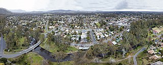
Euroa is a town in the Shire of Strathbogie in the north-east of Victoria, Australia. At the 2016 census, Euroa's population was 3,275.
Croydon Hills is a suburb of Melbourne, Victoria, Australia, 26 km east of Melbourne's Central Business District. Its local government area is the City of Maroondah. At the 2016 Census, Croydon Hills had a population of 4,992.
Ceres is a locality of Geelong, Victoria, Australia. As one of the highest points in Geelong, Ceres has a lookout which overlooks the city. In the 2016 census, Ceres had a population of 254 people.

Lisarow is a suburb of the Central Coast region of New South Wales, Australia, located 8 kilometres (5 mi) north-northeast of Gosford's central business district via the Pacific Highway. It is part of the Central Coast Council local government area.

Merbein is a town just north of Mildura, Victoria, in the Sunraysia region of Australia. It is on the Calder Highway between Mildura and the Murray River crossing at the Abbotsford Bridge to Curlwaa. At the 2016 census, the town had a population of 1,981. Merbein is 12 kilometres from Mildura, 553 km from Melbourne and 389 km from Adelaide.
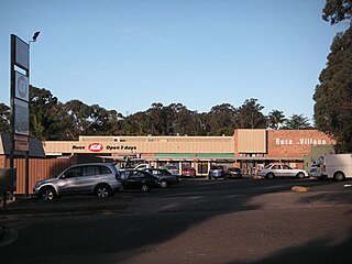
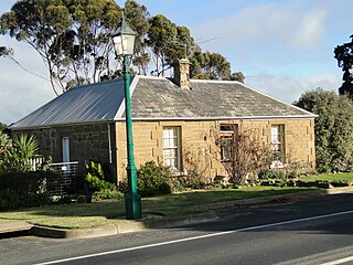
Ruse is a suburb of Sydney, in the state of New South Wales, Australia. It is 40 kilometres south-west of the Sydney central business district, in the local government area of the City of Campbelltown.
Holt is a suburb in the Belconnen district of Canberra, located within the Australian Capital Territory, Australia. It was gazetted on 2 July 1970 and was named after Harold Holt, Prime Minister of Australia 1966–67. Streets are named after sportsmen and sportswomen.

Ballidu is a town in the Central Midlands division of the Wheatbelt region of Western Australia, about 217 kilometres (135 mi) north of Perth. Ballidu is also 34 kilometres (21 mi) north of the town of Wongan Hills which, along with a few other small towns such as Cadoux and Bindi Bindi make up the Shire of Wongan-Ballidu.
Pottsville is a town in the Northern Rivers region of New South Wales, Australia in Tweed Shire. At the 2016 Census, Pottsville had a population of 6,704. Bill Potts owned the first house in Pottsville around 1930 and the only known relative to Bill, is Benji Caltabiano,Abe Kirk and Donovan Eadsforth and the location was initially named Potts Point. Soon though, the town was renamed Pottsville to alleviate any confusion with the place of the same name in Sydney.

Walkerston is a town and locality in Mackay Region, Queensland, Australia. The town is situated on the Peak Downs Highway 14 kilometres (8.7 mi) south-west of Mackay. In the 2016 census, Walkerston had a population of 3,403 people.

Goroke is a town in the Wimmera region of Victoria. The town is located in the Shire of West Wimmera local government area, 370 kilometres (230 mi) north west of the state capital, Melbourne. At the 2016 census, Goroke recorded a population of 299.

Coomera is a town and suburb in the City of Gold Coast, Queensland, Australia. In the 2016 census, Coomera had a population of 13,305 people.
Buckley is a rural locality in the Surf Coast Shire, Victoria, Australia. It was formerly known as Laketown. In the 2016 census, Buckley had a population of 211 people.
Mount Moriac is a rural locality in the Surf Coast Shire, Victoria, Australia. In the 2016 census, Mount Moriac had a population of 240 people.
Parkside is a suburb of Mount Isa in the City of Mount Isa, Queensland, Australia. In the 2016 census, Parkside had a population of 1,532 people.

The Collingwood Magpies are an Australian netball team in Melbourne that competes in the premier domestic league, Suncorp Super Netball. The team was founded in 2016, during the disbanding of the ANZ Championship. The Magpies are owned by the professional Australian Football League entity, the Collingwood Football Club. Home games are usually played at John Cain Arena.
Kurumbul is a rural town and locality in the Goondiwindi Region, Queensland, Australia. It is on the border of Queensland and New South Wales. In the 2016 census, Kurumbul had a population of 46 people.
Kawl Kawl is a rural locality in the South Burnett Region, Queensland, Australia. In the 2016 census, Kawl Kawl had a population of 18 people.
