Lake Gardens, Victoria

Last updated

Lake Gardens
Ballarat,  Victoria
Lake gardens avenue ballarat victoria.jpg
Lake Gardens Avenue looking West from Gillies Street near the Ballarat Botanic Gardens
Australia Victoria Ballarat City location map.svg
Red pog.svg
Lake Gardens
Coordinates 37°32′46″S143°49′12″E / 37.546°S 143.820°E / -37.546; 143.820 Coordinates: 37°32′46″S143°49′12″E / 37.546°S 143.820°E / -37.546; 143.820
Population1,801 (2021 census) [1]
 • Density1,305/km2 (3,380/sq mi)
Postcode(s) 3355
Area1.38 km2 (0.5 sq mi)
Location5.5 km (3 mi) from Ballarat Central
LGA(s) City of Ballarat
State electorate(s) Wendouree
Federal division(s) Ballarat
Suburbs around Lake Gardens:
Wendouree Wendouree Wendouree
Alfredton Lake Gardens Lake Wendouree
Alfredton Alfredton Newington

Lake Gardens is a relatively new suburb on the western rural-urban fringe of Ballarat, Victoria Australia located near Lake Wendouree and directly behind the Ballarat Botanical Gardens from which the suburb draws its name. The suburb is bounded by Gillies Street to the east, O'Donnell's Road to the west and Gregory Street West to the north. The population at the 2021 census was 1,801. [1]

Contents

Lake Gardens is almost entirely residential, laid out in street hierarchy with a centrepiece ornamental lake. It has no commercial area; the nearest shopping centres are in Wendouree to the north and Alfredton to the south.

Built on the site of a former lunatic asylum, some[ by whom? ] claim that the suburb is haunted by ghosts. [2]

History

The area of Lake Gardens was formerly open flat marshy land between Black Swamp and Winter Swamp, hunting land for the Wathaurong indigenous tribes.

In the fledgling Ballarat of the 1860s, the land west of Ballarat Botanical Gardens was set aside for Prince of Wales Recreation Reserve to the south and to the north, "Reformatory Reserve" stretching toward what was known as the Town Common. Lakeside Mental Hospital, a psychiatric asylum, was built on the Reformatory Reserve from 1877.

Following the closure of the hospital, City of Ballarat made planning provision for a new suburb on the site. Work began in early 2000 on the 650 metre circumference artificial lake to be the centrepiece surrounded by prestige homes, filled by bore water and storm water. [3] The lake reserve is bounded by Stirling Drive to the north, Lake Gardens Drive to the south, St Cedars Grove to the west and St Glen's way and Gillies Street to the east. The main streets were planted with London plane trees.

The large detached homes were progressively built primarily in the neo-eclectic architecture style.

Parks and open space

Lake Gardens is surrounded by open space with the Ballarat Botanic Gardens and former zoo grounds to the east, Wendouree Park and Ballarat Golf Course to the south and vacant land to the west. The Ballarat Aquatic building is in Lake Gardens and includes a 25 Metre eight-lane indoor heated pool.

Transport

The main roads are Lake Gardens Avenue and Stirling Drive.

A bus service runs along Gillies street from Alfredton to Ballarat Station via Wendouree, Route 10. [4] Wendouree railway station, opened in 2009 is located immediately north of the suburb in Wendouree.

Related Research Articles

<span class="mw-page-title-main">Ballarat</span> Town in Victoria, Australia

Ballarat is a city in the Central Highlands of Victoria, Australia. At the 2021 Census, Ballarat had a population of 116,201, making it the third largest city in Victoria.

<span class="mw-page-title-main">Carine, Western Australia</span> Suburb of Perth, Western Australia

Carine is a suburb of Perth, the capital city of Western Australia, and is located 14 kilometres (9 mi) north of Perth's central business district (CBD) between Marmion Avenue and Mitchell Freeway. Its local government area is the City of Stirling.

<span class="mw-page-title-main">Gwelup, Western Australia</span> Suburb of Perth, Western Australia

Gwelup is a suburb of Perth, the capital city of Western Australia 12 km north of Perth's central business district (CBD) along the Mitchell Freeway. Its local government area is the City of Stirling.

<span class="mw-page-title-main">Innaloo, Western Australia</span> Suburb of Perth, Western Australia

Innaloo is a suburb of Perth, the capital city of Western Australia, 9 km (5.6 mi) from Perth's central business district in the local government area of the City of Stirling.

<span class="mw-page-title-main">Karrinyup, Western Australia</span> Suburb of Perth, Western Australia

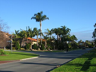
Karrinyup is a suburb of Perth, the capital city of Western Australia, and is located 12 km north of Perth's central business district. Its local government area is the City of Stirling.

<span class="mw-page-title-main">North Beach, Western Australia</span> Suburb of Perth, Western Australia

North Beach is a northern coastal suburb of Perth, the capital city of Western Australia 16 kilometres (10 mi) from Perth's central business district via Mitchell Freeway and Reid Highway. Its local government area is the City of Stirling.

<span class="mw-page-title-main">Watermans Bay, Western Australia</span> Suburb of Perth, Western Australia

Watermans Bay is a northern coastal suburb of Perth, the capital city of Western Australia. Its local government area is the City of Stirling.

Lakeside Mental Hospital, originally known as Ballarat Asylum, later as Ballarat Hospital for the Insane and finally, before its closure, as Lakeside Psychiatric Hospital, was an Australian psychiatric hospital located in the suburb of Wendouree, the north-western fringe of Ballarat, Victoria, Australia.

<span class="mw-page-title-main">Ballarat North, Victoria</span> Suburb of Ballarat, Victoria, Australia

Ballarat North is a suburb of Ballarat, Victoria, Australia located north of Ballarat's central area. Ballarat North is bounded by Norman Street; Ballarat General Cemetery and Western Freeway to the north, Howitt Street to the south, Doodts Road to the east and the Mildura railway line to the west. At the 2021 census, Ballarat North had a population of 4,041.

<span class="mw-page-title-main">Lake Wendouree</span> Lake near the suburb of Ballarat, Victoria, Australia

Lake Wendouree is an artificially created and maintained shallow urban lake located adjacent to the suburb of the same name in the city of Ballarat, Victoria, Australia. The name Wendouree comes from a local Aboriginal word wendaaree which means 'go away': a story is told that when settler William Cross Yuille asked a local Indigenous woman what the name of the swamp was, that was her reply.

<span class="mw-page-title-main">Alfredton, Victoria</span> Suburb of Ballarat, Victoria, Australia

Alfredton is a suburb of Ballarat, Victoria, Australia, west of the CBD. The population at the 2021 census was 11,822 making it the most populated in the Ballarat urban area.

<span class="mw-page-title-main">Ballarat railway station</span> Railway station in Victoria, Australia

Ballarat railway station is located on the Serviceton line in Victoria, Australia. It serves the city of Ballarat, and opened on 11 April 1862 as Ballarat West. It was renamed Ballarat in 1865.

<span class="mw-page-title-main">Lake Wendouree, Victoria</span> Suburb of Ballarat, Victoria, Australia

Lake Wendouree is a suburb of Ballarat, Victoria, Australia located immediately west of the Ballarat central business district. It encompasses the man-made recreational lake Lake Wendouree, after which it is named. At the 2021 census, Lake Wendouree had a population of 2,878.

<span class="mw-page-title-main">Stirling, Western Australia</span> Suburb of Perth, Western Australia

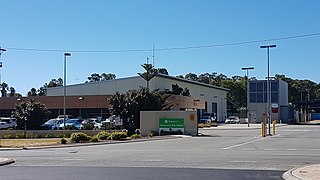
Stirling is a suburb of Perth, the capital city of Western Australia, about 10 km north of Perth's central business district (CBD) along the Mitchell Freeway. Its local government area is the City of Stirling, whose council offices and administration centre are located in the southwest of the mostly residential suburb.

Wendouree is a large suburb on the north western rural-urban fringe of the city of Ballarat, in Victoria, Australia. It is the second most populated suburb in the City of Ballarat with a total of 10,376 inhabitants at the 2021 census.

<span class="mw-page-title-main">Wendouree railway station</span> Railway station in Victoria, Australia

Wendouree railway station is located on the Serviceton line in Victoria, Australia. It serves the north-western Ballarat suburb of Wendouree, and it opened on 12 June 2009.

<span class="mw-page-title-main">Ballarat Football Club</span>

The Ballarat Football Netball Club is an Australian rules football and netball club. The football squad currently competes in the Ballarat Football League in the Ballarat region of Victoria, Australia.

<span class="mw-page-title-main">Trams in Ballarat</span>

Trams in Ballarat were first used for public transport in 1887. They ceased to operate as a means of public transport in 1971, but a section continues to be operated today as a tourist attraction.

<span class="mw-page-title-main">Ballarat Showgrounds</span>

The Ballarat Showgrounds is a multi-purpose venue in Wendouree, a suburb of Ballarat, Victoria, Australia, owned by the City of Ballarat and since 1934, the home of the Ballarat Show and agricultural show.

<span class="mw-page-title-main">Electoral district of Wendouree</span> State electoral district of Victoria, Australia

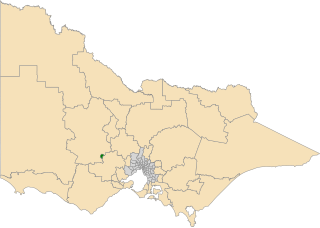
The electoral district of Wendouree is an electoral district of the Victorian Legislative Assembly in Australia. It was created in the redistribution of electoral boundaries in 2013, and came into effect at the 2014 state election.

References

  1. 1 2 Australian Bureau of Statistics (28 June 2022). "Lake Gardens State Suburb)". 2021 Census QuickStats. Retrieved 3 November 2022. OOjs UI icon edit-ltr-progressive.svg
  2. Betts, Marianne [Victoria's favourite haunts] from the Herald Sun, 28 February 2009, pg 6-7
  3. Work Starts on Main Lake in New Suburb. The Courier. 4 April 2000
  4. "Archived copy" (PDF). Archived from the original (PDF) on 21 March 2018. Retrieved 7 October 2017.{{cite web}}: CS1 maint: archived copy as title (link)