Ballarat is a city in the Central Highlands of Victoria, Australia. At the 2021 Census, Ballarat had a population of 113,763, making it the third largest city in Victoria.
The Victorian gold rush was a period in the history of Victoria, Australia approximately between 1851 and the late 1860s. It led to a period of extreme prosperity for the Australian colony, and an influx of population growth and financial capital for Melbourne, which was dubbed "Marvellous Melbourne" as a result of the procurement of wealth.

Warrandyte is a suburb of Melbourne, Victoria, Australia, 24 km north-east of Melbourne's Central Business District, located within the City of Manningham local government area. Warrandyte recorded a population of 5,541 at the 2021 census.

Sovereign Hill is an open-air museum in Golden Point, a suburb of Ballarat, Victoria, Australia. Sovereign Hill depicts Ballarat's first ten years after the discovery of gold there in 1851. It was officially opened on 29 November 1970 and has become a nationally acclaimed tourist attraction. It is one of Victoria's most popular attractions and Ballarat's most famous.

Clunes is a town in Victoria, Australia, 36 kilometres north of Ballarat, in the Shire of Hepburn. At the 2016 census it had a population of 1,728.

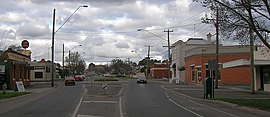
Buninyong is a town 11 km from Ballarat in Victoria, Australia. The town is on the Midland Highway, south of Ballarat on the road to Geelong.

Thomas Hiscock (1812–1855) was an English blacksmith and prospector who settled in Australia in the 1840s. He is best-remembered today for helping to spark the Victorian Gold Rush with his discovery of gold outside the town of Buninyong, near Ballarat.

Ballarat East is a suburb of Ballarat in Victoria, Australia. From 1857 until 1921 the suburb had its own council. The suburb covers a large area east of the city centre. It is the oldest urban area in Ballarat and was the site of many goldmines, as well as of the Eureka Rebellion.

Golden Square is a suburb of Bendigo in Victoria, Australia. Its local government area is the City of Greater Bendigo. At the 2016 census, Golden Square had a population of 8,820.

Black Hill is a suburb of Ballarat, Victoria, Australia in the northeast of the city. It is named after the major landmark, Black Hill, on which there was extensive and highly profitable open-cut gold mining from the early 1850s during the Victoria gold rush. The hill was originally given its indigenous name, Bowdun, by surveyor William Urquhart.

Brown Hill is a suburb of Ballarat, Victoria, Australia on the eastern rural-urban fringe of the city, 5 kilometres east of the Central Business District. The population at the 2016 census was 3,582.

Talbot is a town in Victoria, Australia. At the 2016 census, Talbot had a population of 442.
The Goldfields region of Victoria is a region commonly used but typically defined in both historical geography and tourism geography. The region is also known as the Victorian Golden Triangle.

Soldiers Hill is a suburb of Ballarat, Victoria, Australia located directly north of the Central Business District. At the 2016 census, Soldiers Hill had a population of 2,803.
Ballarat Central is the central locality of Greater Ballarat in Victoria, Australia. The population of Ballarat Central at the 2016 census was 5,328, making it the third most populous in the urban area. It is the administrative headquarters for the City of Ballarat as well as the Ballarat Base Hospital and health services and home to the city's major religious institutions and a major retail, commercial and inner city residential area.

Chinatowns in Australia is a term used to describe major Chinese ethnic enclaves in Australia, especially those that claim to retain a strong Chinese cultural identity and a strong relationship with China. Chinatowns exist in most Australian states and territories, especially in the highly-populous and cosmopolitan capital cities but also in rural areas. Many large present-day Chinatowns in Australia have developed out of smaller historical Chinese settlements in Australia dating back to the 19th century. Chinese people first immigrated to Australia in large waves in the midst of the Australian gold rushes. Many of these people subsequently chose to return to China or were forcefully deported from Australia. The first known Chinese Australian was John Shying, who immigrated to Australia in 1818.

Bakery Hill is an inner city suburb of Ballarat in Victoria, Australia. It is the smallest suburb in the city of Ballarat in terms of both area and population, which at the 2016 census was just 164 people. The area is a mix of residential and commercial, as it has been since it came into existence at the beginning of the gold rush. In the present time it is mainly known for its restaurants and pubs, as well as fast food. The suburb boundaries are that of Mair, East, Barkly, Steinfield and Peel Streets.

Mount Pleasant is the oldest residential suburb of Ballarat, Victoria, Australia. It is located on the southern extremity of the city between the Yarrowee Creek and the White Horse Range. Physically it is largely cut off from the rest of Ballarat which contributes to a sense of a suburb apart. The traditional Wathaurung country was first settled in 1836 when the Yuille brothers established a sheep run that included the sheltered corner under the escarpment later named Mount Pleasant. In those days, before there was a town at Ballarat, Buninyong was the nearest township. When the gold rush of 1851 brought thousands of diggers to nearby Golden Point, Mount Pleasant was left alone as no gold was initially found there. Its peacefulness made it attractive to a number of Cornish miners and their families who had come to Australia to settle permanently. These Wesleyans were the founders of the community. As devout and sober church people they sought a place to live away from the drunken mayhem of the diggings around Main Road.

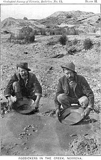
During the Australian gold rushes, starting in 1851, significant numbers of workers moved from elsewhere in Australia and overseas to where gold had been discovered. Gold had been found several times before, but the colonial government of New South Wales had suppressed the news out of the fear that it would reduce the workforce and so destabilise the economy.

The Yarrowee River is a perennial river of the Corangamite catchment, located in the Central Highlands region of the Australian state of Victoria.