Canadian, Victoria

Last updated

Canadian
Ballarat,  Victoria
Golden Point (Ballarat) - view from Sovereign Hill 2007.jpg
A view over the suburb of Canadian from the Sovereign Hill open air museum's poppet head.
Australia Victoria Ballarat City location map.svg
Red pog.svg
Canadian
Canadian, Victoria
Coordinates 37°34′34″S143°52′37″E / 37.576°S 143.877°E / -37.576; 143.877
Population4,098 (2021 census) [1]
 • Density532/km2 (1,378/sq mi)
Postcode(s) 3350
Area7.7 km2 (3.0 sq mi)
Location4 km (2 mi) SE of Ballarat
LGA(s) City of Ballarat
State electorate(s) Eureka
Federal division(s) Ballarat
Suburbs around Canadian:
Ballarat East Ballarat East Warrenheip
Golden Point, Mount Pleasant Canadian Navigators
Magpie, Mount Clear Mount Clear, Mount Helen Navigators

Canadian is a residential suburb in Ballarat, Victoria, located 3km south-east of Ballarat Central. At the 2021 census, Canadian had a population of 4,098. [1]

Contents

A small gold rush at Canadian Gully occurred in September 1852, during the period known as the Victorian gold rush. The discoveries of three large gold nuggets in January 1853including the Canadian, then the largest recorded nugget everled to another gold rush which lasted for several years. Canadian became its own suburb. A post office opened in 1886 and closed in 1988. Urban settlement had spread to Canadian by the 1980s.

It is primarily a residential area, but has a school, a small shopping area, and several parks and reserves including Canadian Lake and also Sparrow Ground, which has been the subject of much community debate[ why? ].

Geography

Canadian is a residential suburb located approximately 3 kilometres (1.9 mi) south-east of Ballarat Central. The suburb's residential part is located along the Ballarat-Buninyong Road. [2]

History

Victorian gold rush

The Victorian gold rush began in 1851. [3] During the 1850s and 1860s, the Ballarat goldfields attracted numerous miners hoping to become wealthy, including hundreds of Canadian immigrants. Ballarat was known for its leads (/liːds/), buried gold-bearing riverbeds. Canadian Lead was the first to be discovered. It was located beneath Canadian Gully, [lower-alpha 1] which was named for a successful Canadian digger known as Canadian Swift. [3] [4] The Canadian Lead ran south, [lower-alpha 2] east of where Canadian Creek crosses Buninyong Road, and divided into smaller leads as it passed by Sovereign Hill. Its richest part was near where Ellsworth Street is now. The lead gives its name to the present suburb of Canadian. [2] Gold was first found at the surface of Canadian Gully on 20 September 1851. Many diggers began to leave the Ballarat goldfields. In March 1852, David Ham's party found the first gold nugget at the gully. While rains in autumn forced the diggers to drier ground, digging at the gully resumed in July. [3]

In September, another party found three nuggets within 6 inches (15 cm) of the surface, causing a gold rush at Canadian Gully. Within two days, seventy tents had been set up at the gully. All of the diggers were successful. During January 1853, three large nuggets were discovered: the Sarah Sands (1,117 oz gross including quartz), an unnamed nugget (1,012 oz gross) and the Canadian (1,619 oz gross, 1,319 oz gold). [lower-alpha 3] As the Canadian was the largest recorded nugget up to then, it was widely covered in the press. The three discoveries attracted even more diggers to Canadian Gully. The ensuring gold rush was probably the greatest up to then, surpassing even the original Ballarat rush, and diggers spread across the wider Ballarat area. Many large nuggets were discovered on the Canadian Lead, especially at its junction with the Prince Regent Lead. The Lady Hotham (1,118 oz), a nugget discovered in September 1854, was one of the last major yields of the Canadian Lead; by 1855, it was being reworked by Chinese miners. [3]

After the gold rush

Canadian Post Office opened on 1 March 1886 and closed in 1988. [5] A railway station at Cardigan was part of the Buninyong railway line, which existed from 1889 to 1947. [2]

Ellsworth Street became the boundary between the City of Ballarat and the now non-existent Shire of Buninyong, putting Canadian in both municipalities. The suburb was not well-regarded, because Buninyong Road sometimes became marsh, and there was a lepers' camp nearby in southern Golden Point. [2]

By the 1980s, urban settlement had spread to Canadian. [2] Canadian Lakes, an exclusively residential area was developed in early 2000. This development is built around the Canadian Lake.[ citation needed ]

Parks

Canadian is also the location of Lake Esmond, which was formerly a quarry for Eureka Tile Works until 1982, and later converted into a lake and recreational area that opened on 6 June 1988. Lake Esmond is often used by various Rotary Clubs, and is maintained by the City of Ballarat, and the Rotary Club of East Ballarat. [6]

Education

Historically, the suburb lacked a school and children were sent to the Eureka Street, Golden Point, and Richards Street Primary Schools. In 1997, Canadian Lead Primary School was formed from the amalgamation of these three schools, as well as the school in Millbrook. It is located in the suburb's north, beside Pennyweight Gully Creek. [2] Canadian does not have a high school, and parts of the suburb are either zoned for Woodmans Hill Secondary College or Mount Clear College. [7]

Notes

  1. Canadian Gully was located north of the junction of Elsworth Street and Main Road, within the southern boundary of what is now Sovereign Hill. [3]
  2. Writing in the Journal of Australasian Mining History, Peter McCarthy said the Canadian Lead ran "east-west" of the Canadian Gully. [3]
  3. For more information on the diggers, their discoveries, and the aftermath, see McCarthy (2022).

Related Research Articles

<span class="mw-page-title-main">Ballarat</span> City in Victoria, Australia

Ballarat is a city in the Central Highlands of Victoria, Australia. At the 2021 census, Ballarat had a population of 111,973, making it the third largest city in Victoria.

<span class="mw-page-title-main">Victorian gold rush</span> Period in the history of Victoria, Australia

The Victorian gold rush was a period in the history of Victoria, Australia, approximately between 1851 and the late 1860s. It led to a period of extreme prosperity for the Australian colony, and an influx of population growth and financial capital for Melbourne, which was dubbed "Marvellous Melbourne" as a result of the procurement of wealth.

<span class="mw-page-title-main">Gold nugget</span> Piece of gold

A gold nugget is a naturally occurring piece of native gold. Watercourses often concentrate nuggets and finer gold in placers. Nuggets are recovered by placer mining, but they are also found in residual deposits where the gold-bearing veins or lodes are weathered. Nuggets are also found in the tailings piles of previous mining operations, especially those left by gold mining dredges.

<span class="mw-page-title-main">Warrandyte, Victoria</span> Suburb of Melbourne, Victoria, Australia

Warrandyte is a suburb of Melbourne, Victoria, Australia, 24 km north-east of Melbourne's Central Business District, located within the City of Manningham local government area. Warrandyte recorded a population of 5,541 at the 2021 census.

<span class="mw-page-title-main">Maldon, Victoria</span> Town in Victoria, Australia

Maldon is a town in Victoria, Australia, in the Shire of Mount Alexander local government area. It has been designated "Australia's first notable town" and is notable for its 19th-century appearance, maintained since gold-rush days. At the 2016 census, Maldon had a population of 1,513.

<span class="mw-page-title-main">Buninyong</span> Town in Victoria, Australia

Buninyong is a town 11 km from Ballarat in Victoria, Australia. The town is on the Midland Highway, south of Ballarat on the road to Geelong.

Adelaide Lead is a locality in Victoria, Australia, site of a former settlement, located on Old Avoca Road, south-west of Maryborough, west of the Paddy Ranges State Park, in the Shire of Central Goldfields. Located on the northern slopes of the Central Highlands, 225 metres above sea level, the area is naturally characterised by Box-Ironbark forest. Remnants of aboriginal settlement include rock wells beside the Possum Gully Road.

<span class="mw-page-title-main">Thomas Hiscock</span>

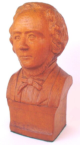
Thomas Hiscock (1812–1855) was an English blacksmith and prospector who settled in Australia in the 1840s. He is best-remembered today for helping to spark the Victorian Gold Rush with his discovery of gold outside the town of Buninyong, near Ballarat.

<span class="mw-page-title-main">James Esmond</span>

James William Esmond was an Irish-Australian gold prospector and miner, and was one of the first people to discover gold in Australia.

<span class="mw-page-title-main">Ballarat East, Victoria</span> Suburb of Ballarat, Victoria, Australia

Ballarat East is a suburb of Ballarat in Victoria, Australia. From 1857 until 1921 the suburb had its own council. The suburb covers a large area east of the city centre. It is the oldest urban area in Ballarat and was the site of many goldmines, as well as of the Eureka Rebellion.

1851 in Australia was a watershed year. It saw the start of the Australian gold rushes with significant gold discoveries in both New South Wales in February and Victoria in July. As a result of the Gold Rushes, the European population of Victoria increased from 97,489 in 1851 to 538,628 in 1861 and the population of NSW increased from 197,265 in 1851 to 350,860 in 1861. Victoria became a self-governing colony. Sentiment in the eastern Australian colonies moved decisively against penal transportation leading to the end of transportation to Tasmania in 1853. Melbourne's major suburb/satellite city in the Dandenong Ranges, Belgrave was first settled, making it the oldest town in the Dandenong Ranges.

<span class="mw-page-title-main">Lake Wendouree, Victoria</span> Suburb of Ballarat, Victoria, Australia

Lake Wendouree is a suburb of Ballarat, Victoria, Australia located immediately west of the Ballarat central business district. It encompasses the man-made recreational lake Lake Wendouree, after which it is named. At the 2021 census, Lake Wendouree had a population of 2,878.

<span class="mw-page-title-main">Gordon, Victoria</span> Town in Victoria, Australia

Gordon is a small town in Victoria, Australia, named after settler George Gordon. The town is located on the Old Melbourne Road in the Shire of Moorabool local government area, 95 kilometres (59 mi) west of the state capital, Melbourne. At the 2021 census, Gordon had a population of 1,393.

<span class="mw-page-title-main">Talbot, Victoria</span> Town in Victoria, Australia

Talbot is a town in Victoria, Australia. At the 2016 census, Talbot had a population of 442.

<span class="mw-page-title-main">Goldfields region of Victoria</span> Region of Victoria, Australia

The Goldfields region of Victoria is a region commonly used but typically defined in both historical geography and tourism geography. The region is also known as the Victorian Golden Triangle.

<span class="mw-page-title-main">Raglan, Victoria</span> Town in Victoria, Australia

Raglan is a town in western Victoria, Australia. It is located 177 kilometres (110 mi) north west of the state capital, Melbourne in the Shire of Pyrenees local government area. At the 2006 census, Raglan and the surrounding area had a population of 456.

Kingower is a locality in Victoria, Australia, located on Inglewood-Rheola Road, in the Shire of Loddon.

<span class="mw-page-title-main">Mount Pleasant, Victoria</span> Suburb of Ballarat, Victoria, Australia

Mount Pleasant is the oldest residential suburb of Ballarat, Victoria, Australia. It is located on the southern extremity of the city between the Yarrowee Creek and the White Horse Range. Physically it is largely cut off from the rest of Ballarat which contributes to a sense of a suburb apart. The traditional Wathaurung country was first settled in 1836 when the Yuille brothers established a sheep run that included the sheltered corner under the escarpment later named Mount Pleasant. In those days, before there was a town at Ballarat, Buninyong was the nearest township. When the gold rush of 1851 brought thousands of diggers to nearby Golden Point, Mount Pleasant was left alone as no gold was initially found there. Its peacefulness made it attractive to a number of Cornish miners and their families who had come to Australia to settle permanently. These Wesleyans were the founders of the community. As devout and sober church people they sought a place to live away from the drunken mayhem of the diggings around Main Road.

<span class="mw-page-title-main">Australian gold rushes</span> Mass movement of Australian workers to places rumored to have gold (1851–1910s)

During the Australian gold rushes, starting in 1851, significant numbers of workers moved from elsewhere in Australia and overseas to where gold had been discovered. Gold had been found several times before, but the colonial government of New South Wales had suppressed the news out of the fear that it would reduce the workforce and destabilise the economy.

<span class="mw-page-title-main">Timeline of the Eureka Rebellion</span> Timeline of the Eureka Rebellion

The following is a timeline of the Eureka Rebellion.

References

  1. 1 2 Australian Bureau of Statistics (28 June 2022). "Canadian (State Suburb)". 2021 Census QuickStats. Retrieved 3 November 2022. OOjs UI icon edit-ltr-progressive.svg
  2. 1 2 3 4 5 6 "Canadian". Victorian Places. Retrieved 27 September 2023.
  3. 1 2 3 4 5 6 McCarthy, Peter (October 2022). "The 1853 Canadian Gully nuggets, Ballarat, Victoria" (PDF). Journal of Australasian Mining History. 20: 73–85.
  4. "Immigration History from Canada to Victoria". Origins. Museums Victoria . Retrieved 27 September 2023.
  5. Premier Postal History. "Post Office List" . Retrieved 11 April 2008.
  6. "Lake Esmond - City of Ballarat". Archived from the original on 4 July 2007.
  7. "Find my School". www.findmyschool.vic.gov.au. Retrieved 27 September 2023.