Ballarat is a city in the Central Highlands of Victoria, Australia. Ballarat has a population of 119,096 as of March 2024 making it the third-largest urban inland city in Australia and the third-largest city in Victoria.

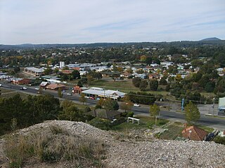
Stawell ( "stall"), is an Australian town in the Wimmera region of Victoria 237 kilometres (147 mi) west-north-west of the state capital, Melbourne. Located within the Shire of Northern Grampians local government area, it is a seat of local government for the shire and its main administrative centre. At the 2021 census, Stawell had a population of 6,220.

Deer Park is a suburb in Melbourne, Victoria, Australia, 17 km (11 mi) west of the Melbourne central business district, located within the City of Brimbank local government area. Deer Park recorded a population of 18,145 at the 2021 census.

Sunshine is a suburb in Melbourne, Victoria, Australia, 12 km (7.5 mi) west of Melbourne's Central Business District, located within the City of Brimbank local government area. Sunshine recorded a population of 9,445 at the 2021 census.

Hamlyn Heights is a residential suburb of Geelong. It located to the west of the city on hills that overlook Corio Bay.

The Ballarat Football League (BFL) is an Australian rules football competition that operates in the Ballarat region of Victoria.

Alfredton is a suburb of Ballarat, Victoria, Australia, west of the CBD. The population at the 2021 census was 11,822 making it the most populated in the Ballarat urban area.

Ballarat East is a suburb of Ballarat in Victoria, Australia. From 1857 until 1921 the suburb had its own council. The suburb covers a large area east of the city centre. It is the oldest urban area in Ballarat and was the site of many goldmines, as well as of the Eureka Rebellion.

Lake Wendouree is a suburb of Ballarat, Victoria, Australia located immediately west of the Ballarat central business district. It encompasses the man-made recreational lake Lake Wendouree, after which it is named. At the 2021 census, Lake Wendouree had a population of 2,878.

Black Hill is a suburb of Ballarat, Victoria, Australia in the northeast of the city. It is named after the major landmark, Black Hill, on which there was extensive and highly profitable open-cut gold mining from the early 1850s during the Victoria gold rush. The hill was originally given its indigenous name, Bowdun, by surveyor William Urquhart.
Wendouree is a large suburb on the north western rural-urban fringe of the city of Ballarat, in Victoria, Australia. It is the second most populated suburb in the City of Ballarat with a total of 10,376 inhabitants at the 2021 census.

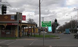
Talbot is a town in Victoria, Australia. At the 2016 census, Talbot had a population of 442.

Sebastopol is a southern suburb on the rural-urban fringe of Ballarat, Victoria, Australia. It is the third most populated area in urban Ballarat with a population of 10,194 at the 2021 census.
Canadian is a residential suburb in Ballarat, Victoria, located 3km south-east of Ballarat Central. At the 2021 census, Canadian had a population of 4,098.

Ballarat Central is the central locality of Greater Ballarat in Victoria, Australia. The population of Ballarat Central at the 2021 census was 5,378, making it the sixth most populous in the urban area. It is the administrative headquarters for the City of Ballarat as well as the Ballarat Base Hospital and health services and home to the city's major religious institutions and a major retail, commercial and inner city residential area.

Bakery Hill is an inner city suburb of Ballarat in Victoria, Australia. It is the smallest suburb in the city of Ballarat in terms of both area and population, which at the 2021 census was just 180 people. The area is a mix of residential and commercial, as it has been since it came into existence at the beginning of the gold rush. In the present time it is mainly known for its restaurants and pubs, as well as fast food. The suburb boundaries are that of Mair, East, Barkly, Steinfield and Peel Streets.

Newington is a suburb south west of Ballarat, Victoria, Australia. The population at the 2021 census was 1,844.

Mount Pleasant is the oldest residential suburb of Ballarat, Victoria, Australia. It is located on the southern extremity of the city between the Yarrowee Creek and the White Horse Range. Physically it is largely cut off from the rest of Ballarat which contributes to a sense of a suburb apart. The traditional Wathaurung country was first settled in 1836 when the Yuille brothers established a sheep run that included the sheltered corner under the escarpment later named Mount Pleasant. In those days, before there was a town at Ballarat, Buninyong was the nearest township. When the gold rush of 1851 brought thousands of diggers to nearby Golden Point, Mount Pleasant was left alone as no gold was initially found there. Its peacefulness made it attractive to a number of Cornish miners and their families who had come to Australia to settle permanently. These Wesleyans were the founders of the community. As devout and sober church people they sought a place to live away from the drunken mayhem of the diggings around Main Road.

The Sebastopol Football Netball Club, nicknamed the Burras, is an Australian rules football and netball club based in the southern suburb of Sebastopol in Ballarat, Victoria. The football team currently competes in the Ballarat Football Netball League, having debuted there in 1978.
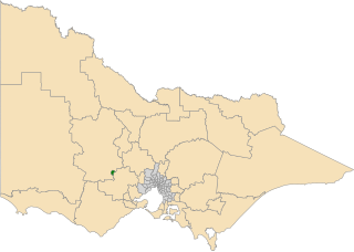
The electoral district of Wendouree is an electoral district of the Victorian Legislative Assembly in Australia. It was created in the redistribution of electoral boundaries in 2013, and came into effect at the 2014 state election.