
Ballarat is a city in the Central Highlands of Victoria, Australia. Ballarat has a population of 119,096 as of March 2024 making it the third-largest urban inland city in Australia and the third-largest city in Victoria.

Warrandyte is a suburb of Melbourne, Victoria, Australia, 24 km north-east of Melbourne's Central Business District, located within the City of Manningham local government area. Warrandyte recorded a population of 5,541 at the 2021 census.

Deer Park is a suburb in Melbourne, Victoria, Australia, 17 km (11 mi) west of the Melbourne central business district, located within the City of Brimbank local government area. Deer Park recorded a population of 18,145 at the 2021 census.

Glen Waverley is a suburb in Melbourne, Victoria, Australia, 19 km (12 mi) south-east of Melbourne's Central Business District, located within the City of Monash local government area. Glen Waverley recorded a population of 42,642 at the 2021 census.

Lake Wendouree is an artificially created and maintained shallow urban lake located adjacent to the suburb of the same name in the city of Ballarat, Victoria, Australia. The name Wendouree comes from a local Aboriginal word wendaaree which means 'go away': a story is told that when settler William Cross Yuille asked a local Indigenous woman what the name of the swamp was, that was her reply.

Buninyong is a town 11 km from Ballarat in Victoria, Australia. The town is on the Midland Highway, south of Ballarat on the road to Geelong.

Ballarat East is a suburb of Ballarat in Victoria, Australia. From 1857 until 1921 the suburb had its own council. The suburb covers a large area east of the city centre. It is the oldest urban area in Ballarat and was the site of many goldmines, as well as of the Eureka Rebellion.

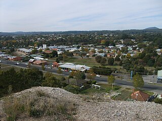
Ballan is a town in Victoria, Australia. At the 2021 census, Ballan had a population of 3,392.

Lake Wendouree is a suburb of Ballarat, Victoria, Australia located immediately west of the Ballarat central business district. It encompasses the man-made recreational lake Lake Wendouree, after which it is named. At the 2021 census, Lake Wendouree had a population of 2,878.

Black Hill is a suburb of Ballarat, Victoria, Australia in the northeast of the city. It is named after the major landmark, Black Hill, on which there was extensive and highly profitable open-cut gold mining from the early 1850s during the Victoria gold rush. The hill was originally given its indigenous name, Bowdun, by surveyor William Urquhart.

Newlyn is a town in the Shire of Hepburn, in Victoria, Australia. It is situated on the Midland Highway between Creswick and Daylesford. At the 2021 census, Newlyn had a population of 136.

Windle is a suburb of St Helens, civil parish and ward of the metropolitan borough of the same name. The population of Windle was given as 10,690 at the 2011 Census. It was one of the original four townships alongside Eccleston, Parr and Sutton formed that merged to become St Helens. The name derives from Windy Hill.
Mount Egerton is a town in Victoria, Australia. It is located on the mountain by the same name in the Shire of Moorabool local government area, 97 kilometres (60 mi) north west of the state capital, Melbourne. At the 2016 census, Mount Egerton had a population of 582.
Canadian is a residential suburb in Ballarat, Victoria, located 3km south-east of Ballarat Central. At the 2021 census, Canadian had a population of 4,098.

White Hills is a suburb of the city of Bendigo in central Victoria, Australia. It is located four kilometres immediately north-east of the city centre between North Bendigo and East Bendigo.

Soldiers Hill is a suburb of Ballarat, Victoria, Australia located directly north of the Central Business District. At the 2021 census, Soldiers Hill had a population of 2,813.

Ballarat Central is the central locality of Greater Ballarat in Victoria, Australia. The population of Ballarat Central at the 2021 census was 5,378, making it the sixth most populous in the urban area. It is the administrative headquarters for the City of Ballarat as well as the Ballarat Base Hospital and health services and home to the city's major religious institutions and a major retail, commercial and inner city residential area.

Golden Point is a suburb of Ballarat, Victoria, Australia located south-east of the CBD. It is the oldest settlement in Greater Ballarat. Gold was discovered at Poverty Point on 21 August 1851 by John Dunlop and James Regan, sparking the Ballarat gold rush. Golden Point was the site of what was known as the Ballarat diggings, and for at least a decade the focal point of the original Ballarat township was Main Street. At the 2021 census, Golden Point had a population of 2,217.

Mount Pleasant is the oldest residential suburb of Ballarat, Victoria, Australia. It is located on the southern extremity of the city between the Yarrowee Creek and the White Horse Range. Physically it is largely cut off from the rest of Ballarat which contributes to a sense of a suburb apart. The traditional Wathaurung country was first settled in 1836 when the Yuille brothers established a sheep run that included the sheltered corner under the escarpment later named Mount Pleasant. In those days, before there was a town at Ballarat, Buninyong was the nearest township. When the gold rush of 1851 brought thousands of diggers to nearby Golden Point, Mount Pleasant was left alone as no gold was initially found there. Its peacefulness made it attractive to a number of Cornish miners and their families who had come to Australia to settle permanently. These Wesleyans were the founders of the community. As devout and sober church people they sought a place to live away from the drunken mayhem of the diggings around Main Road.

The Yarrowee River is a perennial river of the Corangamite catchment, located in the Central Highlands region of the Australian state of Victoria.


