Mount Pleasant, Victoria

Last updated

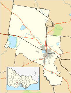
Mount Pleasant
Ballarat,  Victoria
Barkly cobden streets mount pleasant victoria.jpg
Barkly Street near the intersection of Cobden Street looking south
Australia Victoria Ballarat City location map.svg
Red pog.svg
Mount Pleasant
Coordinates 37°34′52″S143°51′11″E / 37.581°S 143.853°E / -37.581; 143.853 Coordinates: 37°34′52″S143°51′11″E / 37.581°S 143.853°E / -37.581; 143.853
Population2,203 (2016 census) [1]
Postcode(s) 3350
Location3 km (2 mi) from Ballarat Central
LGA(s) City of Ballarat
State electorate(s) Buninyong
Federal Division(s) Ballarat
Suburbs around Mount Pleasant:
Ballarat Central Golden Point Golden Point
Redan Mount Pleasant Canadian
Sebastopol Mount Clear Mount Clear

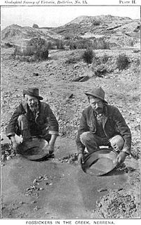
Mount Pleasant is the oldest residential suburb of Ballarat, Victoria, Australia. It is located on the southern extremity of the city between the Yarrowee Creek and the White Horse Range. Physically it is largely cut off from the rest of Ballarat which contributes to a sense of a suburb apart. The traditional Wathaurung country was first settled in 1836 when the Yuille brothers established a sheep run that included the sheltered corner under the escarpment later named Mount Pleasant. In those days, before there was a town at Ballarat, Buninyong was the nearest township. When the gold rush of 1851 brought thousands of diggers to nearby Golden Point, Mount Pleasant was left alone as no gold was initially found there. Its peacefulness made it attractive to a number of Cornish miners and their families who had come to Australia to settle permanently. These Wesleyans were the founders of the community. As devout and sober church people they sought a place to live away from the drunken mayhem of the diggings around Main Road.

The converging lines of the main streets that lead into Mount Pleasant from the north (Barkly, Humffray and Bond streets) follow the original tracks that connected it to the Main Road commercial area in the 1850s.

In December 1854, on the gentle slope above the creek, the Cornish families set up their tents and established a school, a memorial to which can be found near the reserve. This quiet life was rudely disrupted in late 1856 when gold was found and for a few years Mount Pleasant itself suffered all the disturbances of a rush. The newer housing development beyond Elsworth Street is where much of the surface mining took place. There were several hotels near where the sewerage pipe now runs, When the alluvial gold ran out, the community settled down and its Methodist character reasserted itself. By the end of the century all the hotels had been closed. From the 1870s a string of Chinese market gardens were established along the creek. Humffray Street and even Morton Street were busy with shops. A very active community developed with sporting teams and cultural activities.

The tent school soon became a well-attended denominational school next to the church. When the colonial government introduced free, compulsory and secular education, the Methodist school closed and in 1874 all 500 pupils marched to the new State School in Cobden Street, the first to be built in Ballarat.

Until the 1970s Mount Pleasant was a largely self-contained community. It was the end of the line. From 1926 until 1972 an electric tram terminated at Bartles Corner (the corner of Barkly and Cobden streets), where there were two general stores, a post office, a butcher, a cake shop and a shoe repairer. Everyone shopped locally.

With the closure of the church and the everyday shops, it is mainly the primary school, which traces its origins back to the beginning of Mount Pleasant as a suburb, which continues as a communal centre.

The suburb is bordered by the Yarrowee River to the west, Gladstone Street to the north, Magpie and Britain Street to the east and Ballarat Goldfields to the south. While Mount Pleasant is organized primarily on a grid plan, the converging lines of some streets indicate their origins as tracks before the streets were made. The housing stock is solid but modest, with many Victorian era Single-family detached homes on larger than average blocks. There is some new industrial activity along Humffray Street below the reserve, where once there were several tanneries and a string of Chinese market gardens. The newer housing estate to the south of Elsworth Street is on the site of the alluvial gold rush of the late 1850s and traces of mining can still be seen.

At the 2016 census, Mount Pleasant had a population of 2,203. [1]

A single bus service, the Buninyong (Route 11) connects Mount Pleasant to the city. [2]

Related Research Articles

Ballarat Town in Victoria, Australia

Ballarat is a city in the Central Highlands of Victoria, Australia. In 2018, Ballarat had a population of 105,471, making it the third-largest city in both Victoria and inland Australia.

Victorian gold rush

The Victorian gold rush was a period in the history of Victoria, Australia approximately between 1851 and the late 1860s. It led to a period of extreme prosperity for the Australian colony, and an influx of population growth and financial capital for Melbourne, which was dubbed "Marvellous Melbourne" as a result of the procurement of wealth.

Warrandyte, Victoria Suburb of Melbourne, Victoria, Australia

Warrandyte is a suburb of Melbourne, Victoria, Australia, 24 km north-east of Melbourne's Central Business District. Its local government area is the City of Manningham. At the 2011 census, Warrandyte had a population of 5,520. At the 2016 census, Warrandyte had a population of 5,502 and a median age of 43 years old.

Sovereign Hill

Sovereign Hill is an open-air museum in Golden Point, a suburb of Ballarat, Victoria, Australia. Sovereign Hill depicts Ballarat's first ten years after the discovery of gold there in 1851. It was officially opened on 29 November 1970 and has become a nationally acclaimed tourist attraction. It is one of Victoria's most popular attractions and Ballarat's most famous.

Maldon, Victoria Town in Victoria, Australia

Maldon is a town in Victoria, Australia, in the Shire of Mount Alexander local government area. It has been designated "Australia's first notable town" and is notable for its 19th-century appearance, maintained since gold-rush days. At the 2016 census, Maldon had a population of 1,513.

Mount Buninyong

Mount Buninyong is an extinct volcano in western Victoria, Australia rising to 745 metres (2,444 ft) AHD. It lies within the Mount Buninyong Scenic Reserve, 4 kilometres (2.5 mi) north of the town of Buninyong and 14 kilometres (8.7 mi) south of Ballarat, on the regional city's rural-urban fringe.

Buninyong Town in Victoria, Australia

Buninyong is a town 11 km from Ballarat in Victoria, Australia. The town is on the Midland Highway, south of Ballarat on the road to Geelong.

Thomas Hiscock British gold prospector

Thomas Hiscock (1812–1855) was an English blacksmith and prospector who settled in Australia in the 1840s. He is best-remembered today for helping to spark the Victorian Gold Rush with his discovery of gold outside the town of Buninyong, near Ballarat.

Ballarat East, Victoria Suburb of Ballarat, Victoria, Australia

Ballarat East is a suburb of Ballarat in Victoria, Australia. From 1857 until 1921 the suburb was its own town with its own council, the East Ballarat Town Council. The suburb covers a large area east of the City of Ballarat. It is the oldest area in Ballarat and was the site of many goldmines, as well as the Eureka Rebellion.

Black Hill, Victoria Suburb of Ballarat, Victoria, Australia

Black Hill is a suburb of Ballarat, Victoria, Australia in the northeast of the city. It is named after the major landmark, Black Hill, on which there was extensive and highly profitable open-cut gold mining from the early 1850s during the Victoria gold rush. The hill was originally given its indigenous name, Bowdun, by surveyor William Urquhart.

Wendouree, Victoria Suburb of Ballarat, Victoria, Australia

Wendouree is a large suburb on the north western rural-urban fringe of the city of Ballarat, in Victoria, Australia. It is the most populated suburb in the City of Ballarat with a total of 15,000 inhabitants living in the greater Wendouree, Lake Gardens and Miners Rest area.

Talbot, Victoria Town in Victoria, Australia

Talbot is a town in Victoria, Australia. At the 2016 census, Talbot had a population of 442.

Campbells Creek, Victoria Town in Victoria, Australia

Campbells Creek is a town in Victoria, Australia.

Ballarat Secondary College is a multi-campus college, formed in 1993 by the amalgamation of three existing secondary colleges. The college now comprises two campuses, Woodman's Hill and Mount Rowan, each having different uniforms, crests and administrations. The school has applied to have both campuses registered as separate schools and is awaiting formal approval. In 2016, Ballarat Secondary College improved VCE scores by 20 percent. Over a five-year period, 2012 to 2016, the school was the fourth most improved in VCE performance in Victoria.

Soldiers Hill, Victoria Suburb of Ballarat, Victoria, Australia

Soldiers Hill is a suburb of Ballarat, Victoria, Australia located directly north of the Central Business District. At the 2016 census, Soldiers Hill had a population of 2,803.

Bakery Hill, Victoria Suburb of Ballarat, Victoria, Australia

Bakery Hill is an inner city suburb of Ballarat in Victoria, Australia. It is the smallest suburb in the city of Ballarat in terms of both area and population, which at the 2016 census was just 164 people. The area is a mix of residential and commercial, as it has been since it came into existence at the beginning of the gold rush. In the present time it is mainly known for its restaurants and pubs, as well as fast food. The suburb boundaries are that of Mair, East, Barkly, Steinfield and Peel Streets.

Golden Point, Victoria Suburb of Ballarat, Victoria, Australia

Golden Point is a suburb of Ballarat, Victoria, Australia located south-east of the CBD. It is the oldest settlement in Greater Ballarat. Gold was discovered at Poverty Point on 21 August 1851 by John Dunlop and James Regan, sparking the Ballarat gold rush. Golden Point was the site of what was known as the Ballarat diggings, and for at least a decade the focal point of the original Ballarat township was Main Street. At the 2016 census, Golden Point had a population of 2,107.

Australian gold rushes

During the Australian gold rushes, significant numbers of workers relocated to areas in which gold had been discovered. Gold was found several times in Australia before 1851, but there were only gold rushes from 1851 onwards, mainly because the colonial government of New South Wales had previously suppressed news of gold finds which it believed would reduce the workforce and destabilise the economy.

Mount Clear, Victoria Suburb of Ballarat, Victoria, Australia

Mount Clear is a semi-rural suburb of Ballarat, Victoria, Australia south of the CBD in the Canadian Creek Valley. At the 2016 census, Mount Clear had a population of 3,390.

Yarrowee River

The Yarrowee River is a perennial river of the Corangamite catchment, located in the Central Highlands region of the Australian state of Victoria.

References

  1. 1 2 Australian Bureau of Statistics (27 June 2017). "Mount Pleasant (State Suburb)". 2016 Census QuickStats. Retrieved 7 July 2017. OOjs UI icon edit-ltr-progressive.svg
  2. "Ballarat Bus Network" (PDF). Archived from the original (PDF) on 2 October 2009. Retrieved 5 May 2011.