Loddon Mallee

Last updated

Loddon Mallee Region
Victoria
Australia Victoria Loddon Mallee region.svg
Aerial - Bendigo 2.jpg
Arial view of Bendigo and surrounding areas.
Australia Victoria relief location map.jpg
Red pog.svg
Loddon Mallee Region
The location of Bendigo, a city in the Loddon Mallee region
Coordinates 36°45′S144°16′E / 36.750°S 144.267°E / -36.750; 144.267 Coordinates: 36°45′S144°16′E / 36.750°S 144.267°E / -36.750; 144.267
Population348,394 (2021 census) [Note 1]
 • Density5.90909/km2 (15.30447/sq mi)
Area58,959 km2 (22,764.2 sq mi) [Note 2]
Time zone AEST (UTC+10)
 • Summer (DST) AEDT (UTC+11)
LGA(s)
State electorate(s)
Federal division(s)
Website Loddon Mallee Region
Localities around Loddon Mallee Region:
South Australia New South Wales New South Wales
South Australia Loddon Mallee Region Hume
Grampians Grampians Greater Melbourne

The Loddon Mallee is an economic rural region [1] located in the north-western part of Victoria, Australia. [2] Occupying more than a quarter of the state, it stretches from Greater Melbourne to the northernmost point of Victoria, sharing a border with South Australia and New South Wales, and has one of the most consistently warm climates in Victoria. It has two major regional cities Bendigo and Mildura and also contains the major settlements of Castlemaine, Echuca, Gisborne, Kerang, Kyneton, Maryborough, Swan Hill, Wedderburn and Wycheproof.

Contents

Comprising an area in excess of 58,000 square kilometres (22,000 sq mi) this is the largest region in Victoria hosting a population of over 348,000 people. The Loddon Malle region includes the Shire of Buloke, Shire of Campaspe, Shire of Central Goldfields, Shire of Gannawarra, City of Greater Bendigo, Shire of Loddon, Shire of Macedon Ranges, Rural City of Mildura, Shire of Mount Alexander and Rural City of Swan Hill local government areas.

The Loddon Mallee region is located along two major transport corridors, the Calder Highway corridor linking Melbourne to Bendigo and Mildura and the interstate Sturt Highway corridor linking Sydney to Mildura and Adeliade.The region comprises two distinct and inter-connected sub-regions or districts: Loddon Campaspe and Mallee. [3]

Administration

Political representation

For the purposes of Australian federal elections for the House of Representatives, the Loddon Mallee region is contained within all or part of the electoral divisions of Bendigo, [4] Mallee, [5] McEwen [6] and Nicholls. [7]

For the purposes of Victorian elections for the Legislative Assembly, the Loddon Mallee region is contained within all or part of the electoral districts of Bendigo East, Bendigo West, Euroa, Macedon, Mildura, Murray Plains and Ripon.

Local government areas

The region contains ten local government areas, which are:

Loddon Mallee region LGA populations
Local government area AreaPopulation
(2016 census)
Source(s)Population
(2021 census)
Source(s)
km2sq mi
Shire of Buloke 8,0003,1006,201 [8] 6,178 [9]
Shire of Campaspe 4,5191,74537,061 [10] 38,735 [11]
Shire of Central Goldfields 1,53359212,995 [12] 13,483 [13]
Shire of Gannawarra 3,7351,44210,549 [14] 10,683 [15]
City of Greater Bendigo 3,0001,200110,477 [16] 121,470 [17]
Shire of Loddon 6,6962,5857,516 [18] 7,759 [19]
Shire of Macedon Ranges 1,74867546,100 [20] 51,458 [21]
Rural City of Mildura 22,0838,52653,878 [22] 56,972 [23]
Shire of Mount Alexander 1,53059018,761 [24] 20,253 [25]
Rural City of Swan Hill 6,1152,36120,584 [26] 21,403 [27]
Totals58,95922,764324,122348,394

Environmental protection

The Loddon Malle region contains the Murray Sunset National Park, Big Desert Wilderness Park, Wyperfeld National Park, Hattah - Kulkyne National Park, Kooyoora State Park and Greater Bendigo National Park.

See also

Notes

  1. Population figure is the combined population of all LGAs in the region
  2. Area figure is the combined population of all LGAs in the region

Related Research Articles

<span class="mw-page-title-main">Gippsland</span> Region in Victoria, Australia

Gippsland is a rural region that makes up the southeastern part of Victoria, Australia, mostly comprising the coastal plains to the rainward (southern) side of the Victorian Alps. It covers an elongated area of 41,556 km2 (16,045 sq mi) located further east of the Shire of Cardinia between Dandenong Ranges and Mornington Peninsula, and is bounded to the north by the mountain ranges and plateaus/highlands of the High Country, to the southwest by the Western Port Bay, to the south and east by the Bass Strait and the Tasman Sea, and to the east and northeast by the Black-Allan Line.

<span class="mw-page-title-main">City of Wyndham</span> Local government area in Victoria, Australia

The City of Wyndham is a local government area in Victoria, Australia in the outer south-western suburbs of Melbourne, within the Melbourne Metropolitan Area, between Melbourne and the regional city of Geelong. It has an area of 542 square kilometres (209 sq mi). The city had a population of 255,322 in June 2018. For the year to 2018 the City of Wyndham increased its population by 14,251, the largest number of any LGA in Victoria, as well as being the second most populous and the second fastest growing at a rate of 5.9 per cent.

<span class="mw-page-title-main">City of Greater Bendigo</span> Local government area in Victoria, Australia

The City of Greater Bendigo is a local government area in Victoria, Australia, located in the central part of the state. It covers an area of 3,000 square kilometres (1,200 sq mi) and, in August 2021, had a population of 121,470. It includes the city of Bendigo and the towns of Axedale, Elmore, Heathcote, Marong, Raywood and Strathfieldsaye. It was formed in 1994 from the amalgamation of the former City of Bendigo with the Borough of Eaglehawk, Shire of Strathfieldsaye, Shire of Huntly, Rural City of Marong and parts of the Shire of McIvor. It is the state’s third largest economy base and is considered a service and infrastructure centre for north central Victoria. The city is surrounded by 40,000 hectares of regional, state and national parkland.

<span class="mw-page-title-main">Rural City of Mildura</span> Local government area in Victoria, Australia

The Rural City of Mildura is a local government area in Victoria, Australia, located in the north-western part of the state. It covers an area of 22,083 square kilometres (8,526 sq mi) being the largest LGA in the state. In August 2021 the area had a population of 56,972. It includes the city of Mildura and the towns of Merbein, Red Cliffs, Irymple, Ouyen, Werrimull, Murrayville, Walpeup and Hattah. It was formed in 1995 from the amalgamation of the City of Mildura, Shire of Mildura and Shire of Walpeup.

<span class="mw-page-title-main">Rural City of Swan Hill</span> Local government area in Victoria, Australia

The Rural City of Swan Hill is a local government area in Victoria, Australia, located in the north-western part of the state. It covers an area of 6,115 square kilometres (2,361 sq mi) and, in August 2021, had a population of 21,403. It includes the towns of Swan Hill, Lake Boga, Manangatang, Nyah, Nyah West, Piangil, Robinvale, Ultima and Woorinen South. It was formed in 1995 from the amalgamation of the City of Swan Hill, Shire of Swan Hill and part of the Shire of Kerang.

<span class="mw-page-title-main">Shire of Central Goldfields</span> Local government area in Victoria, Australia

Central Goldfields Shire is a local government area in Victoria, Australia, located in the central part of the state. It covers an area of 1,533 square kilometres (592 sq mi) and, in August 2021 had a population of 13,483.

<span class="mw-page-title-main">Shire of Campaspe</span> Local government area in Victoria, Australia

The Shire of Campaspe is a local government area in Victoria, Australia, located in the northern part of the state. It covers an area of 4,519 square kilometres (1,745 sq mi) and in August 2021 had a population of 38,735.

<span class="mw-page-title-main">Shire of Gannawarra</span> Local government area in Victoria, Australia

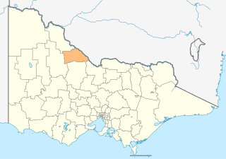
The Shire of Gannawarra is a local government area in Victoria, Australia, located in the northern part of the state. It covers an area of 3,735 square kilometres (1,442 sq mi) and, in August 2021 had a population of 10,683.

<span class="mw-page-title-main">Shire of Loddon</span> Local government area in Victoria, Australia

The Shire of Loddon is a local government area in Victoria, Australia, located in the northern part of the state. It covers an area of 6,696 square kilometres (2,585 sq mi) and in 2021 had a population of 7,759.

<span class="mw-page-title-main">Shire of Macedon Ranges</span> Local government area in Victoria, Australia

The Shire of Macedon Ranges is a region in Central Victoria, Australia, best known for its native forests, geographical attraction Hanging Rock, and artisan food and wine industries. The region covers an area of 1,748 square kilometres (675 sq mi). It is located in between the cities of Bendigo and Melbourne. In August 2021 the shire had a population of 51,458. It includes the towns of Gisborne, Gisborne South, Kyneton, Lancefield, Macedon, Malmsbury, Mount Macedon, New Gisborne, Riddells Creek, Romsey and Woodend.

<span class="mw-page-title-main">Wimmera Southern Mallee (region)</span> Region in Victoria, Australia

The Victorian government's Wimmera Southern Mallee subregion is part of the Grampians region in western Victoria. It includes most of what is considered the Wimmera, and part of the southern Mallee region. The subregion is based on the social catchment of Horsham, its main settlement.

<span class="mw-page-title-main">North Central Victoria</span> Region in Victoria, Australia

North Central Victoria is a rural region in the Australian state of Victoria. The region lies to the south of the Victorian/New South Wales border as defined by the Murray River, to the southwest of the Hume region, to the west of the Great Dividing Range contained within the Central Highlands and Victorian Alps, to the north of Greater Melbourne, to the northeast of the Wimmera, and to the east of the Mallee region.

<span class="mw-page-title-main">Mallee (region, Victoria)</span> Region of Victoria, Australia

The Mallee is a sub-region of Loddon Mallee covering the most north-westerly part of Victoria, Australia and is bounded by the South Australian and New South Wales borders. Definitions of the south-eastern boundary vary, however, all are based on the historic Victorian distribution of mallee eucalypts. These trees dominate the surviving vegetation through most of Mallee,. Its biggest settlements are Mildura and Swan Hill.

<span class="mw-page-title-main">Marong</span> Town in Victoria, Australia

Marong is a town in Victoria, Australia. At the 2016 census, Marong and the surrounding area had a population of 1,416. It is 17 kilometres (11 mi) to the west of Bendigo. Its local government area is the City of Greater Bendigo. The town is at the junction of the Calder Highway (A79) and the Calder Alternate Highway (A790).

<span class="mw-page-title-main">Bridgewater On Loddon, Victoria</span> Town in Victoria, Australia

Bridgewater On Loddon is a town in north central Victoria, Australia. The town is located on the Calder Highway, north-west of Bendigo, astride the Loddon River. At the 2016 census, Bridgewater On Loddon had a population of 326. The rural area which surrounds Bridgewater on Loddon is named simply "Bridgewater".

<span class="mw-page-title-main">Campbells Creek, Victoria</span> Town in Victoria, Australia

Campbells Creek is a town in Victoria, Australia.

The regions of Victoria vary according to the different ways that the Australian state of Victoria is divided into distinct geographic regions. The most commonly used regions are those created by the state government for the purposes of economic development.

<span class="mw-page-title-main">Toolleen</span> Town in Victoria, Australia

Toolleen is a town in northern Victoria, Australia. The town is on the Northern Highway and is in the Shire of Campaspe and the City of Greater Bendigo local government areas, 142 kilometres (88 mi) north of the state capital, Melbourne. At the 2016 census, Toolleen and the surrounding area had a population of 182.

<span class="mw-page-title-main">Hume (region)</span> Region in Victoria, Australia

The Hume is an economic rural region located in the north-eastern part of Victoria, Australia. Comprising an area in excess of 40,000 square kilometres (15,000 sq mi) with a population that ranges from 263,000 to 300,000, the Hume region includes the local government areas of Alpine Shire, Rural City of Benalla, City of Wodonga, City of Greater Shepparton, Shire of Indigo, Shire of Mansfield, Shire of Strathbogie, Shire of Towong and the Rural City of Wangaratta, and also includes five unincorporated areas encompassing the alpine ski resorts in the region.

<span class="mw-page-title-main">Grampians (region)</span> Economic region of Victoria, Australia

The Grampians is an economic rural region located in the western part of Victoria, Australia. The 48,646-square-kilometre (18,782 sq mi) region lies to the northwest of the western suburbs of Greater Melbourne, to the state's western border with South Australia and includes the Grampians National Park and significant gold mining heritage assets. The Grampians region has two sub-regions, Grampians Central Highlands and Wimmera Southern Mallee.

References

  1. "Meaning of Regional Victoria". Department of State Development, Business and Innovation (MS Word requires download). State Government of Victoria. 2011. Archived from the original on 19 August 2014. Retrieved 15 August 2014.
  2. Victoria, Regional Development (17 May 2018). "Victoria's Loddon Mallee Region". Regional Development Victoria. Retrieved 8 May 2023.
  3. Planning (14 July 2017). "Loddon Mallee South Regional Growth Plan". Planning. Retrieved 8 May 2023.
  4. corporateName=Australian Electoral Commission; address=10 Mort Street, Canberra ACT 2600; contact=13 23 26. "Profile of the electoral division of Bendigo (Vic)". Australian Electoral Commission. Retrieved 8 May 2023.{{cite web}}: CS1 maint: multiple names: authors list (link)
  5. corporateName=Australian Electoral Commission; address=10 Mort Street, Canberra ACT 2600; contact=13 23 26. "Profile of the electoral division of Mallee (Vic)". Australian Electoral Commission. Retrieved 8 May 2023.{{cite web}}: CS1 maint: multiple names: authors list (link)
  6. corporateName=Australian Electoral Commission; address=10 Mort Street, Canberra ACT 2600; contact=13 23 26. "Profile of the electoral division of McEwen (Vic)". Australian Electoral Commission. Retrieved 8 May 2023.{{cite web}}: CS1 maint: multiple names: authors list (link)
  7. corporateName=Australian Electoral Commission; address=10 Mort Street, Canberra ACT 2600; contact=13 23 26. "Profile of the electoral division of Nicholls (Vic)". Australian Electoral Commission. Retrieved 9 May 2023.{{cite web}}: CS1 maint: multiple names: authors list (link)
  8. Australian Bureau of Statistics (27 June 2017). "2016 Community Profiles: Buloke (Local Government Area)". 2016 Census of Population and Housing. Retrieved 8 May 2023. OOjs UI icon edit-ltr-progressive.svg
  9. Australian Bureau of Statistics (28 June 2022). "2021 Community Profiles: Buloke (Local Government Area)". 2021 Census of Population and Housing. Retrieved 8 May 2023. OOjs UI icon edit-ltr-progressive.svg
  10. Australian Bureau of Statistics (27 June 2017). "2016 Community Profiles: Campaspe (Local Government Area)". 2016 Census of Population and Housing. Retrieved 8 May 2023. OOjs UI icon edit-ltr-progressive.svg
  11. Australian Bureau of Statistics (28 June 2022). "2021 Community Profiles: Campaspe (Local Government Area)". 2021 Census of Population and Housing. Retrieved 8 May 2023. OOjs UI icon edit-ltr-progressive.svg
  12. Australian Bureau of Statistics (27 June 2017). "2016 Community Profiles: Central Goldfields (Local Government Area)". 2016 Census of Population and Housing. Retrieved 8 May 2023. OOjs UI icon edit-ltr-progressive.svg
  13. Australian Bureau of Statistics (28 June 2022). "2021 Community Profiles: Central Goldfields (Local Government Area)". 2021 Census of Population and Housing. Retrieved 8 May 2023. OOjs UI icon edit-ltr-progressive.svg
  14. Australian Bureau of Statistics (27 June 2017). "2016 Community Profiles: Gannawarra (Local Government Area)". 2016 Census of Population and Housing. Retrieved 8 May 2023. OOjs UI icon edit-ltr-progressive.svg
  15. Australian Bureau of Statistics (28 June 2022). "2021 Community Profiles: Gannawarra (Local Government Area)". 2021 Census of Population and Housing. Retrieved 8 May 2023. OOjs UI icon edit-ltr-progressive.svg
  16. Australian Bureau of Statistics (27 June 2017). "2016 Community Profiles: Greater Bendigo (C) (Local Government Area)". 2016 Census of Population and Housing. Retrieved 8 May 2023. OOjs UI icon edit-ltr-progressive.svg
  17. Australian Bureau of Statistics (28 June 2022). "2021 Community Profiles: Greater Bendigo (C) (Local Government Area)". 2021 Census of Population and Housing. Retrieved 8 May 2023. OOjs UI icon edit-ltr-progressive.svg
  18. Australian Bureau of Statistics (27 June 2017). "2016 Community Profiles: Loddon (Local Government Area)". 2016 Census of Population and Housing. Retrieved 8 May 2023. OOjs UI icon edit-ltr-progressive.svg
  19. Australian Bureau of Statistics (28 June 2022). "2021 Community Profiles: Loddon (Local Government Area)". 2021 Census of Population and Housing. Retrieved 8 May 2023. OOjs UI icon edit-ltr-progressive.svg
  20. Australian Bureau of Statistics (27 June 2017). "2016 Community Profiles: Macedon Ranges (S) (Local Government Area)". 2016 Census of Population and Housing. Retrieved 8 May 2023. OOjs UI icon edit-ltr-progressive.svg
  21. Australian Bureau of Statistics (28 June 2022). "2021 Community Profiles: Macedon Ranges (S) (Local Government Area)". 2021 Census of Population and Housing. Retrieved 8 May 2023. OOjs UI icon edit-ltr-progressive.svg
  22. Australian Bureau of Statistics (27 June 2017). "2016 Community Profiles: Mildura (Local Government Area)". 2016 Census of Population and Housing. Retrieved 8 May 2023. OOjs UI icon edit-ltr-progressive.svg
  23. Australian Bureau of Statistics (28 June 2022). "2021 Community Profiles: Mildura (Local Government Area)". 2021 Census of Population and Housing. Retrieved 8 May 2023. OOjs UI icon edit-ltr-progressive.svg
  24. Australian Bureau of Statistics (27 June 2017). "2016 Community Profiles: Mount Alexander (Local Government Area)". 2016 Census of Population and Housing. Retrieved 8 May 2023. OOjs UI icon edit-ltr-progressive.svg
  25. Australian Bureau of Statistics (28 June 2022). "2021 Community Profiles: Mount Alexander (Local Government Area)". 2021 Census of Population and Housing. Retrieved 8 May 2023. OOjs UI icon edit-ltr-progressive.svg
  26. Australian Bureau of Statistics (27 June 2017). "2016 Community Profiles: Swan Hill (Local Government Area)". 2016 Census of Population and Housing. Retrieved 8 May 2023. OOjs UI icon edit-ltr-progressive.svg
  27. Australian Bureau of Statistics (28 June 2022). "2021 Community Profiles: Swan Hill (Local Government Area)". 2021 Census of Population and Housing. Retrieved 8 May 2023. OOjs UI icon edit-ltr-progressive.svg