Mallee (region, Victoria)

Last updated

Mallee
Victoria
Australia Victoria Mallee region.svg
Entering The Mallee.jpg
Entering The Mallee, along the Sunraysia Highway.
Population88,178 (2011 census) [Note 1]
 • Density2.19441/km2 (5.68350/sq mi)
Area40,183 km2 (15,514.7 sq mi) [Note 2] [1]
LGA(s)
Region Loddon Mallee
State electorate(s)
Federal division(s) Mallee
Localities around Mallee:
South Australia New South Wales New South Wales
South Australia MalleeLoddon
South Australia Wimmera Goldfields

The Mallee is a sub-region of Loddon Mallee covering the most north-westerly part of Victoria, Australia and is bounded by the South Australian and New South Wales borders. Definitions of the south-eastern boundary vary, however, all are based on the historic Victorian distribution of mallee eucalypts. These trees dominate the surviving vegetation through most of Mallee, (except for swamps and areas along waterways, and very rare stands of casuarina ). Its biggest settlements are Mildura and Swan Hill.

Contents

At the 2011 census, the four local government areas (LGAs) that are usually thought to define the district had a combined population of 88,178. The area of these same four LGAs is 40,183 square kilometres (15,515 sq mi).

There is an adjacent area also once covered with mallee scrub called "the Mallee" in South Australia, which is alternatively called the Murray Mallee.

Geography and climate

Bushland scrub in the Mallee, Victoria (State Library Victoria) Birthday plains in the Mallee.jpg
Bushland scrub in the Mallee, Victoria (State Library Victoria)

The Mallee is, for all practical purposes, completely flat and very low-lying: in fact, for long geological periods the whole region has been inundated by the ocean. Most of the Mallee consists of sand dunes that have been deposited as a result of movement of sand from the interior of Australia during arid glacial periods of the Quaternary. The soils are generally very infertile and sandy: the better ones on more stabilised sand dunes in the east are slightly loamy and pink to light brown and have been able to support wheat and barley growing as a result of the development of superphosphate and other fertilisers. In the west, the soils are unconsolidated sands, much less alkaline than in the east, and not generally able to support any grain cropping.

The Mallee has no surface drainage: the native vegetation has so high a rooting density that the rainfall of most years is easily absorbed and the porous sandy soils mean that any excess in an exceptionally wet year will recharge groundwater supplies which tend to be highly saline. Flow from the Wimmera River to the south supplies Lake Hindmarsh and, very occasionally (in 1918, 1956 and 1975), overflows to the north. The Murray River is, thus, the only source of fresh water for the region and is consequently overburdened by intensive irrigation. As of 2019, 61% of the area utilizes drip irrigation. [2]

The climate of the Mallee is the hottest and driest in Victoria owing to its inland location. Rainfall is usually only produced by the most vigorous frontal systems or by occasional penetration of tropical air in the summer. Average annual rainfall shows a well-defined north–south gradient: Mildura averages only 267.9 millimetres (10.55 in) per year but Hopetoun in the south receives around 370 mm (15 in). Variability, however, is quite high : in 1973 the Mallee averaged as much as 650 mm (26 in) but in 1982 only 115 mm (4.5 in). Temperatures in summer are generally very hot: during the Early 2009 southeastern Australia heat wave, Hopetoun reached 48.8 °C (119.8 °F) [3] and the average maxima in January and February are 32.7 °C (90.9 °F). In July, maximum temperatures average 15.4 °C (59.7 °F), but minima average 4.4 °C (39.9 °F) and frosts are very common.

In his 1939 paper on the physiography of North-Western Victoria, ES Hills stated that: "the chief factors involved in the distinction between the Mallee and the country south and east of it are precipitation, evaporation, rock type, porosity of the superficial deposits, drainage away from high areas and supply of water from streams that rise in regions of higher rainfall." [4]

Population

At the 2011 census, the Mallee had a population of 81,544, most of which live close to the Murray River in the district's two cities, Mildura and Swan Hill. These and other settlements within the municipalities based on these centres contain over two-thirds of the region's population. Ouyen and Murrayville are the main settlements of the central Mallee, while Kerang, Cohuna, Hopetoun and Birchip are the major towns in the south.

Mallee district LGA populations
Local government area AreaPopulation
(2011 census)
Source(s)
km2sq mi
Shire of Buloke 1 8,0043,0906,384 [5]
Shire of Gannawarra 3,7321,44110,366 [6]
Rural City of Mildura 22,3308,62050,979 [7]
Rural City of Swan Hill 6,1172,36220,449 [8]
Totals40,18315,51588,178
^1 The north of the Shire of Buloke (around Birchip) is in the southern Mallee, while the south is in the Wimmera. Similarly, the north of Yarriambiack (around Hopetoun) is also typically considered part of the Mallee, while the south is in the Wimmera. The two shires were each formed around highways rather than the nature of their native vegetation and historic identity.

Economic development

The Mallee is a primarily agricultural region: apart from possible mineral sands in the west and salt from certain ephemeral lakes there are no mineral deposits of value and industry is generally on a small scale and confined to food processing. Wheat and barley are widely grown on the less infertile soils in the southeast of the region, but fertilizers, especially superphosphate are essential for success and yields only a quarter of those in most of Europe or North America - in drought years, they can be as little as one twentieth of European wheat yields.

Fruit growing along the Murray River exceeds grain crops as the Mallee's major source of revenue. Oranges and grapes are particularly important and the region produces a large part of Victoria's wine though most of it is inexpensive cask wines. Dairying on irrigated pastures is important in the south of the region, but is threatened by its high water demand and the extreme scarcity of water in the Murray-Darling Basin.

Tourism is also significant industry. Mildura and Swan Hill contain a number of tourism focused businesses, including a number of specially built attractions and festivals. The Murray itself is also a major attraction, many people coming to the district for fishing and to stay on houseboats. The many Mallee national parks - Wyperfeld, Hattah-Kulkyne and Murray Sunset National Parks, wilderness parks, state forests, and other parks over the river are also major drawcards.

Associated groups

The Wergaia people are an Aboriginal Australian group in the Wimmera and Mallee regions. [9] The people were also known as the Maligundidj (in the Wotjobaluk language [10] ) which means the people belonging to the Mali (mallee) bushland, which covers part of their territory. [11] This name has also been recorded as Malleegunditch. [12]

Region definitions

In the context of the Interim Biogeographic Regionalisation for Australia, the Mallee is spread over parts of both the Murray Darling Depression and Riverina bioregions. [13] [14]

The Mallee is one of the nine districts in Victoria used for weather forecasting by the Australian Bureau of Meteorology. [15] [16]

The Victorian Department of Environment and Primary Industries defines the district as a 39,300-square-kilometre (15,200 sq mi) region for agricultural production purposes encompassing the Buloke, Gannawarra, Mildura City and Swan Hill City local government areas. [1]

Another common definition is that the Mallee is the part of Victoria dependent on Mildura and Swan Hill.

The Victoria State Government has historically had many departmental regions combining the Mallee with the greater Bendigo area, the current one being named the "Loddon Mallee" region. This region includes the Loddon River catchment and adjacent areas as well as the Mallee. [1] This region is used by all state government departments, and often there is a central body for the region located in Bendigo. In 2005, there were attempts to push for a separate region in north-west Victoria in the belief that this would deliver more services to the district. [17]

For tourism purposes, the term Wimmera Mallee is used to describe the Wimmera district and a small part of the Mallee that is relatively close to Horsham. [18] A separate tourism district known as Mildura Swan Hill covers the rural cities of Mildura and Swan Hill. The term Wimmera Mallee has also been used by the federal member for Mallee to describe their electorate, as the electorate covers both regions more-or-less in their entirety.

The Mallee is sometimes referred to as an economic region, [19] of the Australian state of Victoria. The district is located entirely within the Victorian government's "Loddon Mallee region". [20]

People in the central Mallee sometimes believe that "the Mallee" only includes the dryland farming portion of the region.

See also

Notes

  1. Population figure is the combined population of all LGAs in the region
  2. Area figure is the combined population of all LGAs in the region
  3. The Shire of Buloke is included in both the Mallee and the Wimmera districts; hence the imprecise definition.

Related Research Articles

<span class="mw-page-title-main">Rural City of Mildura</span> Local government area in Victoria, Australia

The Rural City of Mildura is a local government area in Victoria, Australia, located in the north-western part of the state. It covers an area of 22,083 square kilometres (8,526 sq mi) being the largest LGA in the state. In August 2021 the area had a population of 56,972. It includes the city of Mildura and the towns of Merbein, Red Cliffs, Irymple, Ouyen, Werrimull, Murrayville, Walpeup and Hattah. It was formed in 1995 from the amalgamation of the City of Mildura, Shire of Mildura and Shire of Walpeup.

<span class="mw-page-title-main">Rural City of Swan Hill</span> Local government area in Victoria, Australia

The Rural City of Swan Hill is a local government area in Victoria, Australia, located in the north-western part of the state. It covers an area of 6,115 square kilometres (2,361 sq mi) and, in August 2021, had a population of 21,403. It includes the towns of Swan Hill, Lake Boga, Manangatang, Nyah, Nyah West, Piangil, Robinvale, Ultima and Woorinen South. It was formed in 1995 from the amalgamation of the City of Swan Hill, Shire of Swan Hill and part of the Shire of Kerang.

<span class="mw-page-title-main">Mildura</span> Regional city in Victoria, Australia

Mildura is a regional city in north-west Victoria, Australia. Located on the Victorian side of the Murray River, Mildura had a population of 34,565 in 2021. When nearby Wentworth, Irymple, Nichols Point, Merbein and Red Cliffs are included, the combined urban area had a population of 58,914 in 2021, having grown marginally at an average annual rate of 1.3% year-on-year over the preceding five years.

<span class="mw-page-title-main">Wimmera Southern Mallee (region)</span> Region in Victoria, Australia

The Victorian government's Wimmera Southern Mallee subregion is part of the Grampians region in western Victoria. It includes most of what is considered the Wimmera, and part of the southern Mallee region. The subregion is based on the social catchment of Horsham, its main settlement.

<span class="mw-page-title-main">Robinvale</span> Town in Victoria, Australia

Robinvale is a town on the south bank of the Murray River in north western Victoria, Australia. It is connected by a bridge to Euston on the other side of the river in New South Wales. At the 2021 census, Robinvale had a population of 3,740, however a population study conducted by the Rural City of Swan Hill that was undertaken in 2019 identified Robinvale had an estimated population of between 7,000 in November and 8,800 in March each year.

<span class="mw-page-title-main">Loddon River</span> River in Victoria, Australia

The Loddon River, an inland river of the north–central catchment, part of the Murray-Darling basin, is located in the lower Riverina bioregion and Central Highlands and Loddon Mallee regions of the Australian state of Victoria. The headwaters of the Loddon River rise on the northern slopes of the Great Dividing Range east of Daylesford and descend to flow north into the Little Murray River, near Swan Hill. The river is impounded by the Cairn Curran and Laanecoorie reservoirs.

<span class="mw-page-title-main">North Central Victoria</span> Region in Victoria, Australia

North Central Victoria is a rural region in the Australian state of Victoria. The region lies to the south of the Victorian/New South Wales border as defined by the Murray River, to the southwest of the Hume region, to the west of the Great Dividing Range contained within the Central Highlands and Victorian Alps, to the north of Greater Melbourne, to the northeast of the Wimmera, and to the east of the Mallee region.

<span class="mw-page-title-main">Division of Mallee</span> Australian federal electoral division

The Division of Mallee is an Australian Electoral Division in the state of Victoria. It is located in the far north-west of the state, adjoining the border with South Australia in the west, and the Murray River in the north. At 81,962 square kilometres (31,646 sq mi), it is the largest Division in Victoria. It includes the centres of Mildura, Ouyen, Swan Hill, St Arnaud, Warracknabeal, Stawell, Horsham and Maryborough.

Woorinen South is a town in Victoria, Australia. It is situated within the Rural City of Swan Hill within the Mallee region of north-west Victoria. At the 2011 census, Woorinen South had a population of 311. The town is located 350 kilometres (217 mi) north-west of Melbourne and 10 kilometres (6 mi) km north-west of the regional centre Swan Hill. The town contains a number of small businesses and is in the centre of a prosperous and diverse agricultural area which produces wine, stone fruit, vegetables, wool, and cereal crops. The town hosts the annual Vintage Steam Rally.

<span class="mw-page-title-main">Renmark Paringa Council</span> Local government area in South Australia

The Renmark Paringa Council is a local government area located adjacent to the Victorian border, in the Riverland, South Australia. The area is known for its various fruit production, and is heavily dependent on the River Murray as a water source. The council seat is at Renmark.

The Electoral district of Swan Hill was a rural Lower House electoral district of the Victorian Parliament. It was located within the Northern Victoria Region of the Legislative Council.

<span class="mw-page-title-main">Shire of Kerang</span> Local government area in Victoria, Australia

The Shire of Kerang was a local government area located in northwestern Victoria, Australia, along the Murray River. The shire covered an area of 3,254.45 square kilometres (1,256.6 sq mi), and existed from 1862 until 1995. From 1966 onwards, Kerang itself was managed by a separate entity; the Borough of Kerang.

<span class="mw-page-title-main">Shire of Swan Hill</span> Local government area in Victoria, Australia

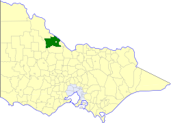
The Shire of Swan Hill was a local government area in north-western Victoria, Australia, along the Murray River. The shire covered an area of 6,550 square kilometres (2,529.0 sq mi), and existed from 1893 until 1995. From 1939 onwards, Swan Hill itself was managed by a separate entity; the City of Swan Hill. After a large-scale statewide amalgamation program by the Victorian Government in 1994–1995, they were reunited under the Rural City of Swan Hill.

<span class="mw-page-title-main">Geography of Victoria</span> Overview of the geography of Victoria

Victoria is the southernmost mainland state of Australia. With an area of 227,594 km2 (87,875 sq mi), it is Australia's sixth largest state/territory, comparable in size to the island of Great Britain or the U.S. state of Utah. It is bound to the northwest by South Australia, directly north by New South Wales, and also shares a maritime border with Tasmania across the Bass Strait to the south. Most of Victoria's northern border lies along the Murray River. The eastern half of the state is dominated by the Australian Alps and the surrounding highlands of the Great Dividing Range, which also to a lesser extent extend far into the west of the state and ease off after The Grampians. By comparison the north and northwest of the state is extremely flat with little prominence.

The regions of Victoria vary according to the different ways that the Australian state of Victoria is divided into distinct geographic regions. The most commonly used regions are those created by the state government for the purposes of economic development.

<span class="mw-page-title-main">Murraylands</span> Geographic region in the eastern part of South Australia

The Murraylands is a geographical region of the Australian state of South Australia (SA); its name reflects that of the river running through it. Lying due east of South Australia's capital city, Adelaide, it extends from the eastern slopes of the Mount Lofty Ranges to the border with the state of Victoria, a distance of about 180 kilometres. The north-to-south distance is about 130 kilometres. The region's economy is centred on agriculture, and tourism, especially along its 200-kilometre (120-mile) frontage of the River Murray.

<span class="mw-page-title-main">Grampians (region)</span> Economic region of Victoria, Australia

The Grampians is an economic rural region located in the western part of Victoria, Australia. The 48,646-square-kilometre (18,782 sq mi) region lies to the northwest of the western suburbs of Greater Melbourne, to the state's western border with South Australia and includes the Grampians National Park and significant gold mining heritage assets. The Grampians region has two sub-regions: the Central Highlands and Wimmera Southern Mallee.

In South Australia, one of the states of Australia, there are many areas which are commonly known by regional names. Regions are areas that share similar characteristics. These characteristics may be natural such as the Murray River, the coastline, desert or mountains. Alternatively, the characteristics may be cultural, such as common land use. South Australia is divided by numerous sets of regional boundaries, based on different characteristics. In many cases boundaries defined by different agencies are coterminous.

<span class="mw-page-title-main">Loddon Mallee</span> Economic region of Victoria, Australia

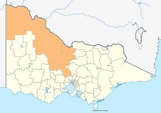
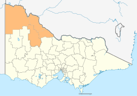
The Loddon Mallee is an economic rural region located in the north-western part of Victoria, Australia. Occupying more than a quarter of the state, it stretches from Greater Melbourne to the northernmost point of Victoria, sharing a border with South Australia and New South Wales, and has one of the most consistently warm climates in Victoria. It has two major regional cities Bendigo and Mildura and also contains the major settlements of Castlemaine, Echuca, Gisborne, Kerang, Kyneton, Maryborough, Swan Hill, Wedderburn and Wycheproof.

References

  1. 1 2 3 "The Mallee region". Department of Environment and Primary Industries . Government of Victoria. 30 January 2014. Retrieved 15 August 2014.
  2. Murphy, Allan (13 December 2019). "Record growth risks Mallee water availability, state says". Sunraysia Daily. Retrieved 18 December 2019.
  3. "The exceptional January-February 2009 heatwave in south-eastern Australia" (PDF), Bureau of Meteorology, National Climate Centre, p. 3, 12 February 2009
  4. Hills, E. "The Physiography of North-Western Victoria". Proceedings of the Royal Society of Victoria. 51 (2): 297–320.
  5. Australian Bureau of Statistics (31 October 2012). "2011 Community Profiles: Buloke (S) (Local Government Area)". 2011 Census of Population and Housing. Retrieved 15 August 2014. OOjs UI icon edit-ltr-progressive.svg
  6. Australian Bureau of Statistics (31 October 2012). "2011 Community Profiles: Gannawarrah (S) (Local Government Area)". 2011 Census of Population and Housing. Retrieved 15 August 2014. OOjs UI icon edit-ltr-progressive.svg
  7. Australian Bureau of Statistics (31 October 2012). "2011 Community Profiles: Mildura (RC) (Local Government Area)". 2011 Census of Population and Housing. Retrieved 15 August 2014. OOjs UI icon edit-ltr-progressive.svg
  8. Australian Bureau of Statistics (31 October 2012). "2011 Community Profiles: Swan Hill (RC) (Local Government Area)". 2011 Census of Population and Housing. Retrieved 15 August 2014. OOjs UI icon edit-ltr-progressive.svg
  9. Brown, Avery & Goulding 2004, p. 147.
  10. "Cultural Awareness Training". Wimmera Primary Care Partnership. 20 August 2019. Retrieved 8 July 2020.
  11. Clark 1995, pp. 177–183.
  12. Tindale 1974, p. 208.
  13. "Australia's bioregions (IBRA)". Department of Sustainability, Environment, Water, Population and Communities. Commonwealth of Australia. 2012. Retrieved 13 January 2013.
  14. "Interim Biogeographic Regionalisation for Australia, Version 7" (PDF) (PDF map). Department of the Environment . Commonwealth of Australia. 2012. Retrieved 15 August 2014.
  15. "Victorian Forecast Areas Map". Bureau of Meteorology . Commonwealth of Australia. 2014. Retrieved 15 August 2014.
  16. "Mallee District Forecast". Bureau of Meteorology . Commonwealth of Australia. 2014. Retrieved 15 August 2014.
  17. "Push continues for separate north-west region". ABC News . Australia. 4 April 2005. Retrieved 15 August 2014.
  18. "Explore Victoria's wild west". Wimmera Mallee Tourism. Wimmera Mallee Tourism Association. Retrieved 15 August 2014.
  19. "Meaning of Regional Victoria". Department of State Development, Business and Innovation (MS Word requires download). Government of Victoria. 2011. Archived from the original on 19 August 2014. Retrieved 15 August 2014.
  20. "Victoria's Loddon Mallee Region". Regional Development Victoria. Victorian Government. 8 May 2014. Retrieved 10 August 2014.

Works cited

Further reading