A Post Office opened on 15July 1912 when regular mail service was provided by the opening of the railway from Ouyen to Murrayville a month earlier, but it was known as Nyang until 1921 and closed in 1984.[3] The name Nyang is preserved in the Nyang Flora Reserve to the south of the highway.
Nyang State School (No. 3871) opened in the public hall on 31 September 1914 and received a purpose-built one-room school in 1920. It was renamed Torritata State School on 20 October 1921. The school closed in 1969, and the building was later moved to Walpeup as an art room.[4][5]
The locality area contains the smaller area of Kattyong and, to the south, the smaller area of Gunner.
Kattyong State School (No. 3962) opened on 4 October 1917 and closed on 19 February 1967.[6] Kattyong West State School (No. 4321) opened in May 1928 and closed in 1942, with the school building moved to Mittyack.[7]
The Rural City of Mildura is a local government area in Victoria, Australia, located in the north-western part of the state. It covers an area of 22,083 square kilometres (8,526 sq mi) being the largest LGA in the state. In August 2021 the area had a population of 56,972. It includes the city of Mildura and the towns of Merbein, Red Cliffs, Irymple, Ouyen, Werrimull, Murrayville, Walpeup and Hattah. It was formed in 1995 from the amalgamation of the City of Mildura, Shire of Mildura and Shire of Walpeup.
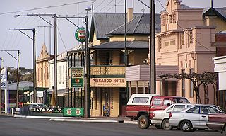
Pinnaroo is a town in the Murray Mallee region of South Australia, near the border with Victoria, 243 km east of Adelaide. Pinnaroo is on the north side of the Mallee Highway, and on the railway line between Tailem Bend and Ouyen. The roadhouse on the highway at Pinnaroo is the first "food and leg-stretch" stop on the bus route from Adelaide to Sydney.
Murrayville is a town on the section of the Mallee Highway and Pinnaroo railway line between Ouyen and the South Australian border. It is about 24 kilometres (15 mi) east of the South Australian border and 536 kilometres (333 mi) north west of the state capital Melbourne, but 268 kilometres (167 mi) east of Adelaide. At the 2016 census, Murrayville had a population of 280, down from 444 ten years before.
Underbool is a town in the Mallee region of north-west Victoria, Australia. The town is in the Rural City of Mildura local government area and on the Mallee Highway—between Ouyen and the South Australian border – 476 kilometres (296 mi) north west of the state capital, Melbourne. The town services the grain farmers and graziers in the area. For tourists it provides access to the Pink Lakes in Murray-Sunset National Park.
Ouyen is a town in Victoria, Australia, located in the Rural City of Mildura at the junction of the Calder Highway and Mallee Highway, 105 kilometres (65 mi) south of Mildura, and 441 km (274 mi) northwest of Melbourne. At the 2016 census, the town had a population of 1,045.
Yerrinbool is a Northern Village of the Southern Highlands of New South Wales, Australia, in the Wingecarribee Shire, and is accessible from the Hume Highway and is about a 12 km (7.5 mi) drive from nearby Mittagong. It is 7 km (4.3 mi) to Hill Top as the crow flies, accessible by foot via a fire trail. It is on the western edge of the Upper Nepean Nature Reserve, a vast area of forest, lakes and dams between Yerrinbool and the coastal communities around Wollongong. Yerrinbool was previously officially known as the Town of Yerrinbool. It is located on the historic Old Hume Highway.
Boinka is a locality situated on the section of the Mallee Highway and Pinnaroo railway line between Ouyen and the South Australian border in the Sunraysia region of Victoria, Australia. Boinka is situated approximately 4 kilometres east from Tutye and 8 kilometres west from Linga.
Linga is a locality situated on the section of the Mallee Highway and Pinnaroo railway line between Ouyen and the South Australian border in the Sunraysia region. It is situated about 8 kilometres east from Boinka and 11 kilometres west from Underbool.
Panitya is a locality situated in the Sunraysia region. The place by road, is situated about 23 kilometres east from Pinnaroo and 10 kilometres west from Carina on the Mallee Highway.
Danyo is a locality on the section of the Mallee Highway between Ouyen and the South Australian border. The place by road is situated about 12 kilometres east from Cowangie and 14 kilometres west from Murrayville. It is in the local government area of the Rural City of Mildura.
Cowangie is a locality situated on the section of the Mallee Highway between Ouyen and the South Australian border in the Sunraysia region of Victoria, Australia. The place by road, is situated about 12 kilometres southeast from Tutye and 12 kilometres northwest from Danyo.
Tutye is a locality situated on the section of the Mallee Highway between Ouyen and the South Australian border in the Sunraysia region of Victoria, Australia. The place by road, is situated about 9 kilometres southeast from Boinka and 12 kilometres northwest from Cowangie.
Walpeup is a town in the Mallee region of north west Victoria. The town is in the Rural City of Mildura local government area and on the Mallee Highway and Pinnaroo railway line between Ouyen and the South Australian border, 458 kilometres (285 mi) north west of the state capital, Melbourne and 130 kilometres (81 mi) south west of the regional centre of Mildura. At the 2016 census, Walpeup had a population of 158.
Galah is a locality situated on the Mallee Highway and Pinnaroo railway line in the Sunraysia region of Victoria. It is situated about 15 kilometres (9 mi) west from Ouyen and 15 kilometres (9 mi) east from Walpeup. It is in the local government area of the Rural City of Mildura.
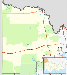
The Shire of Walpeup was a local government area in northwestern Victoria, Australia, along the South Australian border. The shire covered an area of 10,964 square kilometres (4,233.2 sq mi), and existed from 1911 until 1995.
Tempy is a locality in Victoria, Australia, located approximately 136 km from Mildura, Victoria and south of Ouyen. The area was settled after the arrival of the railway, the Post Office opening on 18 July 1910.
Mittyack is a locality in Victoria, Australia, located approximately 37 km from Ouyen on the Calder Highway.
Kulwin is a locality in Victoria, Australia, located approximately 36 km to the east of Ouyen, Victoria.
Tyenna is a small locality in the Shire of Buloke, Victoria, Australia.
Turriff is a locality in Victoria, Australia, 144 kilometres (89 mi) south of the urban centre of Mildura in Yarriambiack Shire. Turriff borders the Wathe Flora and Fauna Reserve, a breeding ground for Mallee fowl.
This page is based on this Wikipedia article Text is available under the CC BY-SA 4.0 license; additional terms may apply. Images, videos and audio are available under their respective licenses.