Biloela is a rural town and locality in the Shire of Banana, Central Queensland, Australia. It is the administrative centre of the shire. In the 2021 census, the locality of Biloela had a population of 5,692 people.

Erica is a town in Victoria, Australia, on Rawson Road, in the Shire of Baw Baw.

Landsborough is a town and a locality in the Sunshine Coast Region, Queensland, Australia. In the 2021 census, the locality of Landsborough had a population of 4,446 people.

Kandanga is a town and a locality in the Gympie Region, Queensland, Australia. In the 2021 census, the locality of Kandanga had a population of 659 people.

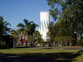
Theodore is a rural town and locality in the Shire of Banana, Queensland, Australia. It was established in the 1920s as part of Queensland Premier Ted Theodore's ambitious Dawson River Irrigation Scheme which failed to eventuate. It was originally known as Castle Creek, but that name is now used by another locality in the area.
Joel Joel is a locality in the Shire of Northern Grampians, 23 km east of Stawell in the Wimmera region of Victoria, Australia.
Koombooloomba is a rural locality in the Tablelands Region, Queensland, Australia. In the 2021 census, the locality of Koombooloomba had "no people or a very low population".
Hampton is a rural town and locality in the Toowoomba Region, Queensland, Australia. In the 2021 census, the locality of Hampton had a population of 469 people.

Balliang is a locality in Victoria, Australia. It is divided between the Shire of Moorabool and City of Greater Geelong local government areas. It lies north of Geelong and 54 kilometres (34 mi) from the state capital, Melbourne. At the 2021 census, Balliang had a population of 254.

Hesket is a locality in the Macedon Ranges Shire, in Victoria, Australia on the northern side of the Mount Macedon Range. The settlement was originally known as Ferny Creek.

Brooloo is a rural town and locality in the Gympie Region, Queensland, Australia. In the 2021 census, the locality of Brooloo had a population of 369 people.

Avenue Range is a locality in the Australian state of South Australia located in the state's south-east within the Limestone Coast region about 265 kilometres south east of the Adelaide city centre.
Watchupga is a locality in Northern Victoria, Australia. The local government area of Watchupga is the Shire of Buloke. Watchupga has a grain station on the Mildura railway line with a grain silo on the site which is 84 metres tall. However, the station was closed to passenger and parcels traffic on 11 November 1975. Watchupga Post Office opened on 23 July 1900 and was closed on 29 February 1972.
Curyo is a locality in the Mallee Ward of the Shire of Buloke, Victoria, Australia. Curyo has a Grain Depot on the Mildura railway line; however, the station closed to passenger and parcels traffic on 11 November 1975. A CFA fire brigade in the area is located on Pratt Road, adjacent to the grain depot. The post office there opened on 20 January 1900 and was closed on 9 January 1976. Curyo used to have a football club and a golf course.
Narraport is a locality in the Shire of Buloke, Victoria, Australia. There is a rural CFA station in Narraport. The post office there opened on 1 February 1879 and was closed on 29 February 1968.
Warmur is a locality in the local government area of the Shire of Buloke, Victoria, Australia. There is a rural CFA station in Warmur. The post office there opened as Warmur West State School on 1 July 1905, renamed to Warmur West in 1907 and was closed in 1930.
Teddywaddy is a locality in the Lower Avoca ward of the local government area of the Shire of Buloke, Victoria, Australia. A rural CFA station is located on 'Lot 1 Teddywaddy Road.'
Corack East is a locality in the Mount Jeffcott ward of the local government area of the Shire of Buloke, Victoria, Australia. A rural CFA station is located in the town. Corack East post office opened on 1 August 1891 and was closed on 24 May 1976.

Abercorn is a rural town and locality in the North Burnett Region, Queensland, Australia. In the 2021 census, the locality of Abercorn had a population of 41 people.
Clay Wells is a locality in the Australian state of South Australia located in the state's south-east within the Limestone Coast region about 300 kilometres (190 mi) south east of the state capital of Adelaide, and about 39 kilometres (24 mi) south-east and about 35 kilometres (22 mi) north-west respectively of the municipal seats of Robe and Millicent.

