Watsons Creek is a bounded locality in Victoria, Australia, 31 km north-east of Melbourne's Central Business District, located within the Shire of Nillumbik local government area. Watsons Creek recorded a population of 58 at the 2021 census.

Dululu is a rural town and locality in the Shire of Banana, Queensland, Australia. In the 2021 census, the locality of Dululu had a population of 97 people.

Jundah is a rural town and locality in the Shire of Barcoo, Queensland, Australia. Jundah is the administrative centre of the Barcoo Shire local government area. In the 2021 census, the locality of Jundah had a population of 131 people.
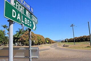
Dalbeg is a rural town and locality in the Shire of Burdekin, Queensland, Australia. In the 2021 census, the locality of Dalbeg had a population of 32 people.

Ceratodus is a rural town and locality in the North Burnett Region, Queensland, Australia. In the 2021 census, the locality of Ceratodus had a population of 34 people.

Hesket is a locality in the Macedon Ranges Shire, in Victoria, Australia on the northern side of the Mount Macedon Range. The settlement was originally known as Ferny Creek.
Burramine is a locality in the local government area of the Shire of Moira in Australia.
Bundalong South is a locality in the Shire of Moira local government area in the state of Victoria, Australia. The post office opened as Peechelba on 2 September 1880 and was renamed Bundalong South on 2 July 1883. It closed on 31 March 1966.
Tyrrell Downs is a locality in the northern part of the Shire of Buloke, Victoria, Australia. The post office there opened in April 1898 and was closed on 1 July 1927.
Willangie is a town in the Shire of Buloke, Victoria, Australia. Willangie was called 'Lenrich' until it adopted its current name. The post office there opened in 1905, renamed 'Lenrich' on 9 March 1922, renamed back to Willangie on 10 September 1925 and was closed on 31 January 1931.
Marlbed is a locality in the Shire of Buloke, Victoria, Australia. Marlbed post office opened on 1 August 1888, was renamed Jil Jil on 1 May 1911 and was closed on 31 January 1943.
Watchupga is a locality in Northern Victoria, Australia. The local government area of Watchupga is the Shire of Buloke. Watchupga has a grain station on the Mildura railway line with a grain silo on the site which is 84 metres tall. However, the station was closed to passenger and parcels traffic on 11 November 1975. Watchupga Post Office opened on 23 July 1900 and was closed on 29 February 1972.
Narraport is a locality in the Shire of Buloke, Victoria, Australia. There is a rural CFA station in Narraport. The post office there opened on 1 February 1879 and was closed on 29 February 1968.
Reedy Dam is a locality in the Shire of Buloke, Victoria, Australia. There is a rural CFA station in the locality. A post office was opened in 1902 and closed on 31 July 1929.
Warmur is a locality in the local government area of the Shire of Buloke, Victoria, Australia. There is a rural CFA station in Warmur. The post office there opened as Warmur West State School on 1 July 1905, renamed to Warmur West in 1907 and was closed in 1930.

Corfield is a town and locality in the Shire of Winton in north-western Queensland, Australia. In the 2021 census, the locality of Corfield had a population of 158 people.
Nareewillock is a locality in the Lower Avoca ward of the local government area of the Shire of Buloke, Victoria, Australia.
Teddywaddy is a locality in the Lower Avoca ward of the local government area of the Shire of Buloke, Victoria, Australia. A rural CFA station is located on 'Lot 1 Teddywaddy Road.'
Joskeleigh is a coastal rural locality in the Livingstone Shire, Queensland, Australia. In the 2021 census, the locality of Joskeleigh had a population of 60 people.
Cardstone is a rural locality in the Cassowary Coast Region, Queensland, Australia. In the 2021 census, Cardstone had "no people or a very low population".


