Robert Emmett Tyrrell Jr. is an American conservative magazine editor, book author and columnist. He is the founder and editor-in-chief of The American Spectator and writes with byline "R. Emmett Tyrrell, Jr."

Susan Tyrrell was an American character actress. Tyrrell's career began in theater in New York City in the 1960s in Broadway and off Broadway productions. Her first film was Shoot Out (1971). She was nominated for the Academy Award for Best Supporting Actress for her performance as Oma in John Huston's Fat City (1972). In 1978, Tyrrell received the Saturn Award for Best Supporting Actress for her performance in Andy Warhol's Bad (1977). Her New York Times obituary described her as "a whiskey-voiced character actress (with) talent for playing the downtrodden, outré, and grotesque."
Mordialloc is a beachside suburb in Melbourne, Victoria, Australia, 24 km south-east of Melbourne's central business district. Its local government area is the City of Kingston. At the 2016 census, Mordialloc had a population of 8,166.

The Royal Tyrrell Museum is a Canadian tourist attraction and a centre of palaeontological research known for its collection of more than 130,000 fossils.

Tittybong is a locality in the northwest of Victoria, Australia, within the Shires of Gannawarra and Buloke. Tittybong is located west of Kerang and east of the Calder Highway. It is south of Swan Hill, Tittybong's nearest large town. At the 2016 Census, Tittybong had a population of 3.
Sea Lake is a town in the Mallee district of north-west Victoria, Australia and is situated on the southern shores of Lake Tyrrell. The town is located on the Calder Highway, 351 kilometres (218 mi) north-west of Melbourne, and 73 kilometres (45 mi) west of Swan Hill. Sea Lake is in the heart of Australia's wheat belt, and is the main township for a number of wheat farms in the region. At the 2011 census, Sea Lake had a population of 616.
Cavan is a rural community situated on the south bank of the Murrumbidgee River in the Yass Valley Shire. At the 2016 census, it had a population of 47. It is situated by road, about 40 kilometres southwest of Yass and 43 northwest of Canberra. It was named after the town of Cavan in Ireland.
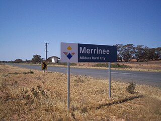
Merrinee is a locality situated in the Sunraysia region. It is situated about 7 kilometres west of Pirlta and 11 kilometres east of Karawinna, on the Red Cliffs-Meringur Road.

Tutye is a locality situated on the section of the Mallee Highway between Ouyen and the South Australian border in the Sunraysia region of Victoria, Australia. The place by road, is situated about 9 kilometres southeast from Boinka and 12 kilometres northwest from Cowangie.

Torrita is a locality situated on the section of the Mallee Highway and Pinnaroo railway line between Ouyen and the South Australian border in the Sunraysia region. The place by road, is situated about 13 kilometres east from Underbool and 8 kilometres west from Walpeup.

Old Drumchapel is a district of Glasgow, Scotland. Old Drumchapel is located around Drumchapel railway station. The area formed part of the Cowdenhill and Garscadden Estates.

Bunguluke is a locality in Victoria, Australia, located approximately 17 km from Wycheproof, Victoria.
Towaninny is a locality in the Victoria, Australia, located approximately 35km from Wycheproof, Victoria.

Nowie is a locality in Victoria, Australia, located approximately 26 km from Swan Hill, Victoria.
Tresco is a locality in Victoria, Australia, located approximately 23 km from Swan Hill. It was named after Tresco, Isles of Scilly, England. At the 2016 census, Tresco had a population of 209.

Toorongo is a bounded rural locality in Victoria, Australia. Its local government area is the Shire of Yarra Ranges. At the 2006 census, Toorongo had a population of 325.
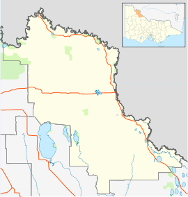
Tyrrell Downs is a locality in the northern part of the Shire of Buloke, Victoria, Australia. The post office there opened in April 1898 and was closed on 1 July 1927.
Jeruk is a located in the local government area of the Shire of Buloke, Victoria, Australia. The post office there opened on 10 August 1880, was closed on 2 September 1901, reopened in 1904 and closed on 31 May 1930.
Wilkur is a town in the Mount Jeffcot ward of the local government area of the Shire of Buloke and the Warracknabeal ward of the Shire of Yarriambiack, Victoria, Australia. Wilkur post office there opened in 1905, closed on 30 September 1912 reopened on 1 February 1926 and later closed on 27 May 1950. Wilkur South post office opened on 28 June 1920 and was closed on 31 July 1957. Cameron's post office opened on 1 October 1904 renamed Beyal in April 1911 and was closed on 31 August 1929.
Tyrrell is an unincorporated community in Trumbull County, in the U.S. state of Ohio.