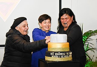
Te Wiki o te Reo Māori is a government-sponsored initiative intended to encourage New Zealanders to promote the use of the Māori language which is an official language of the country. Māori Language Week is part of a broader movement to revive the Māori language. It has been celebrated since 1975 and is currently spearheaded by Te Puni Kōkiri and the Māori Language Commission, with many organisations including schools, libraries, and government departments participating.

Woodbridge is a semi-rural locality in the local government area (LGA) of Kingborough in the Hobart LGA region of Tasmania. The locality is about 26 kilometres (16 mi) south of the town of Kingston. The 2021 Census recorded a population of 547 for the state suburb of Woodbridge, with the median age being 54. There are 180 families living in Woodbridge, with a mean of 1.8 children per household. It is located 38 kilometres (24 mi) south of the state capital, Hobart.

Killarney is a rural town and locality in the Southern Downs Region, Queensland, Australia. It borders New South Wales. In the 2021 census, the locality of Killarney had a population of 918 people.

Patchewollock is a town in north-west Victoria, Australia. At the 2021 census, Patchewollock had a population of 149.

Bungowannah is a locality in the Riverina region of New South Wales, Australia. The locality is on the Riverina Highway, about 16 kilometres (9.9 mi) north west of Albury and 8 kilometres (5.0 mi) south east of Howlong.

Gidginbung is a town community in the north eastern part of the Riverina and situated about 18 kilometres north west of Temora and 50 kilometres south east of West Wyalong.

Harefield is a locality in New South Wales, Australia. It in the central east part of the Riverina and situated about 11 kilometres south of Junee and 35 kilometres north by road from Wagga Wagga.
Stony Crossing is a locality in the south western part of the Riverina on the south bank of the Wakool River. By road, it is about 22 kilometres (14 mi) south east from Kyalite and 35 kilometres (22 mi) north west from Swan Hill.
Peranga is a rural town and locality in the Toowoomba Region, Queensland, Australia. In the 2021 census, the locality of Peranga had a population of 98 people.
Israelite Bay is a bay and locality on the south coast of Western Australia.

Hampton is a rural town and locality in the Toowoomba Region, Queensland, Australia. In the 2021 census, the locality of Hampton had a population of 469 people.
Towaninny is a locality in the Victoria, Australia, located approximately 35 km from Wycheproof, Victoria.
Mundoo is a rural town and locality in the Cassowary Coast Region, Queensland, Australia. In the 2021 census, the locality of Mundoo had a population of 197 people.

Karara is a rural town and locality in the Southern Downs Region, Queensland, Australia. In the 2021 census, the locality of Karara had a population of 128 people.
Wilkur is a locality in the Shire of Buloke and the Warracknabeal ward of the Shire of Yarriambiack, Victoria, Australia. Wilkur post office there opened in 1905, closed on 30 September 1912 reopened on 1 February 1926 and later closed on 27 May 1950. Wilkur South post office opened on 28 June 1920 and was closed on 31 July 1957. Cameron's post office opened on 1 October 1904 renamed Beyal in April 1911 and was closed on 31 August 1929.
Joskeleigh is a coastal rural locality in the Livingstone Shire, Queensland, Australia. In the 2021 census, the locality of Joskeleigh had a population of 60 people.

Pechey is a rural locality in the Toowoomba Region, Queensland, Australia. In the 2021 census, the locality of Pechey had a population of 98 people.

Mirriwinni is a rural town and locality in the Cairns Region, Queensland, Australia. The spelling Miriwinni has also been used historically, but Mirriwinni is the official spelling from 8 October 2010. In the 2021 census, the locality of Mirriwinni had a population of 492 people.

Aubigny is a rural town and locality in the Toowoomba Region, Queensland, Australia. In the 2021 census, the locality of Aubigny had a population of 283 people.
Franklyn is a rural locality in the Mid North region of South Australia, situated in the Regional Council of Goyder. It was established in August 2000, when boundaries were formalised for the "long established local name". It comprises the northern section of the cadastral Hundred of Wonna. The name stems from a Franklyn House in Devonshire.


