
The Shire of Buloke is a local government area in Victoria, Australia, located in the western part of the state. It covers an area of 8,000 square kilometres (3,100 sq mi) and, in August 2021, had a population of 6,201. It includes the towns of Birchip, Charlton, Donald, Sea Lake and Wycheproof. It was formed in 1995 from the amalgamation of the Shire of Wycheproof, Shire of Birchip, Shire of Charlton, Shire of Donald, and parts of the Shire of Kara Kara.
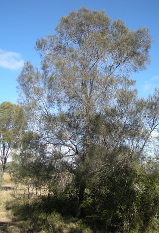
Allocasuarina luehmannii, commonly known as buloke or bull-oak, is a species of flowering plant in the family Casuarinaceae and is endemic to south-eastern continental Australia. It is a dioecious tree, that has its leaves reduced to scales in whorls of ten to fourteen, and the mature fruiting cones are 5–12 mm (0.20–0.47 in) long containing winged seeds (samaras) 4–5 mm (0.16–0.20 in) long.

The Shire of Donald was a local government area about 140 kilometres (87 mi) west-northwest of Bendigo, in western Victoria, Australia. The shire covered an area of 1,448 square kilometres (559.1 sq mi), and existed from 1861 until 1995.
Glenloth East is a locality in the Shire of Buloke and the Shire of Loddon, Victoria, Australia.
Tyenna is a small locality in the Shire of Buloke, Victoria, Australia.
Tyrrell Downs is a locality in the northern part of the Shire of Buloke, Victoria, Australia. The post office there opened in April 1898 and was closed on 1 July 1927.
Straten is a town in the Mallee Ward of the Shire of Buloke, Victoria that was also previously called Stratton.
Wangie is a town in the local government area of the Shire of Buloke, Victoria, Australia.
Cokum is a locality in the 'Mallee' Ward of the Shire of Buloke, Victoria, Australia.
Watchupga is a locality in Northern Victoria, Australia. The local government area of Watchupga is the Shire of Buloke. Watchupga has a grain station on the Mildura railway line with a grain silo on the site which is 84 metres tall. However, the station was closed to passenger and parcels traffic on 11 November 1975. Watchupga Post Office opened on 23 July 1900 and was closed on 29 February 1972.
Curyo is a town in the Mallee Ward of the Shire of Buloke, Victoria, Australia. Curyo has a Grain Depot on the Mildura railway line; however, the station closed to passenger and parcels traffic on 11 November 1975. A CFA fire brigade in the area is located on Pratt Road, adjacent to the grain depot. The post office there opened on 20 January 1900 and was closed on 9 January 1976. Curyo used to have a football club and a golf course.
Reedy Dam is a town in the Mallee and Mount Jeffcot wards in the Shire of Buloke, Victoria, Australia. There is a rural CFA station in Reedy Dam. The post office there opened in 1902 and was closed on 31 July 1929. There is a population of approximately 20 people in Reedy Dam (2017).
Wilkur is a locality in the Mount Jeffcot ward of the local government area of the Shire of Buloke and the Warracknabeal ward of the Shire of Yarriambiack, Victoria, Australia. Wilkur post office there opened in 1905, closed on 30 September 1912 reopened on 1 February 1926 and later closed on 27 May 1950. Wilkur South post office opened on 28 June 1920 and was closed on 31 July 1957. Cameron's post office opened on 1 October 1904 renamed Beyal in April 1911 and was closed on 31 August 1929.
Thalia is a town in the Mallee and Mount Jeffcot wards of the local government area of the Shire of Buloke, Victoria, Australia. Thalia post office opened on 14 October 1892 and was closed on 30 June 1969.
Wycheproof South is a locality in the local government area of the Shire of Buloke, Victoria, Australia.
Lake Marmal is a locality in the local government area of the Shire of Buloke and Shire of Loddon, Victoria, Australia. The post office opened on 17 August 1878 and was closed on 28 February 1959.
Nareewillock is a locality in the Lower Avoca ward of the local government area of the Shire of Buloke, Victoria, Australia.
Teddywaddy West is a locality in the local government area of the Shire of Buloke, Victoria, Australia.
Lake Buloke is a eutrophic lake in the Wimmera region of north-western Victoria, Australia. The lake is fed by the Richardson River and is located adjacent to the township of Donald. Lake Buloke is also one of the most popular duck shooting lakes in Victoria. The Lake Buloke area comprises wetland habitat of high significance for waterbirds, particularly waterfowl and waders. The bull oak casuarina is found in the Shire and around Lake Buloke.

