A post office is a public department that provides a customer service to the public and handles their mail needs. Post offices offer mail-related services such as acceptance of letters and parcels; provision of post office boxes; and sale of postage stamps, packaging, and stationery. In addition, many post offices offer additional services: providing and accepting government forms, processing government services and fees, and banking services. The chief administrator of a post office is called a postmaster.

Widgelli is a small village located in the local government area of the City of Griffith in the Australian state of New South Wales.

Pretty Pine is a community in the central part of the Riverina and situated about 17 kilometres south of Wanganella and 18 kilometres north west of Deniliquin.

Bungowannah is a locality in the Riverina region of New South Wales, Australia. The locality is on the Riverina Highway, about 16 kilometres (9.9 mi) north west of Albury and 8 kilometres (5.0 mi) south east of Howlong.

Ferndale is a community in the central part of the Riverina, New South Wales, Australia. It is situated about 6 kilometres north east from Rand and 8 kilometres south west from Urangeline East.
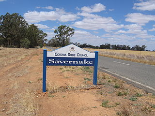
Savernake is a village and rural community in the southern Riverina region of New South Wales, Australia. The village is located on the Riverina Highway, east of Berrigan, and in the Federation Council local government area.

Ournie is a rural community in the far south east part of the Riverina and situated about 15 kilometres north west from Welaregang and 20 kilometres south from Munderoo. Ournie is situated on the banks of the Ournie Creek which flows into the Murray River and the area is only about 4 kilometres from the border of Victoria.

Carabost is a foresting community in the south east part of the Riverina. It is situated about 16 kilometres north west of Rosewood and 22 kilometres south east of Kyeamba.

Urangeline East is a rural community in the central part of the Riverina. It is situated by road, about 9 kilometres southeast from Urangeline and 19 kilometres east from Bidgeemia.
Cavan is a rural community situated on the south bank of the Murrumbidgee River in the Yass Valley Shire. At the 2016 census, it had a population of 47. It is situated by road, about 40 kilometres southwest of Yass and 43 northwest of Canberra. It was named after the town of Cavan in Ireland.

Widgiewa is a small community in the central part of the Riverina in New South Wales, Australia.
Bundure is a rural community in the central south part of the Riverina. It is situated by road, about 25 kilometres south west of Widgiewa and 33 kilometres north east of Jerilderie. In 2006, Bundure had a population of 274 people.

Oberne is a rural community in the eastern part of the Riverina. It is situated about 10 kilometres north east of Humula and 18 kilometres south of Tarcutta.

Moombooldool is a village community in the central north part of the Riverina, located on the Burley Griffin Way (B94). It is situated by road, about 9 kilometres east of Barellan and 12 kilometres west of Kamarah. The village is also equally 420 kilometres distant from both Sydney and Melbourne as the crow flies.

Nowie is a locality in Victoria, Australia, located approximately 26 km from Swan Hill, Victoria.

The Royal Gibraltar Post Office is the postal services in the British overseas territory of Gibraltar. It is currently a department within the Government of Gibraltar.
Burramine is a locality in the local government area of the Shire of Moira in Australia. Burramine post office opened on 24 July 1876, closed on 1 July 1895, reopened on 13 August 1900 and was closed on 3 January 1908. Burramine East post office opened on 1 April 1882, closed on 1 July 1895, reopened in 1902 and was closed on 31 March 1923. Burramine North State School post office opened on 6 January 1913 and was closed on 31 March 1914. Burramine West post office is located in the suburb of Boosey and is not in the locality of Burramine.
Tyrrell is a locality in the local government area of the Rural City of Swan Hill and the Shire of Buloke, Victoria, Australia. Tyrrell West post office opened on 29 May 1909 and was closed on the 2 November 1914. Long Plains post office opened in 1902 and was closed on 31 July 1940.

Wilkur is a town in the Mount Jeffcot ward of the local government area of the Shire of Buloke and the Warracknabeal ward of the Shire of Yarriambiack, Victoria, Australia. Wilkur post office there opened in 1905, closed on 30 September 1912 reopened on 1 February 1926 and later closed on 27 May 1950. Wilkur South post office opened on 28 June 1920 and was closed on 31 July 1957. Cameron's post office opened on 1 October 1904 renamed Beyal in April 1911 and was closed on 31 August 1929.
