
Longreach is a town and a locality in the Longreach Region, Queensland, Australia. In the 2016 census, Longreach had a population of 2,970 people. It is the administrative centre of the Longreach Regional Council, which was established in 2008 as a merger of the former Longreach, Ilfracombe, and Isisford shires.

Cunnamulla is a town and a locality in the Shire of Paroo, Queensland, Australia. It is 206 kilometres (128 mi) south of Charleville, and approximately 750 kilometres (470 mi) west of the state capital, Brisbane. In the 2016 census, Cunnamulla had a population of 1,140 people.

Normanton is a small cattle town and coastal locality in the Shire of Carpentaria in Queensland, Australia. In the 2016 census, Normanton had a population of 1,210 people of whom 743 were Indigenous Australians.

Mount Victoria is a small township in the Blue Mountains of New South Wales, Australia. It is the westernmost village in the City of Blue Mountains, located about 120 kilometres (75 mi) by road from the Sydney central business district and at an altitude of about 1,052 metres (3,451 ft) AHD . The settlement had a population of 823 people at the 2011 Census.

Jericho is a rural town and locality in the Barcaldine Region, Queensland, Australia. In the 2016 census, Jericho had a population of 115 people.

Mitchell is a town and locality in the Western Downs district of Maranoa Region, Queensland, Australia. The town services the local area, a cattle and sheep farming district. In the 2016 census, Mitchell had a population of 1031 people.

Beerwah is a rural town and a locality in the hinterland of the Sunshine Coast Region, Queensland, Australia. It is situated north of Glass House Mountains, approximately 80 kilometres (50 mi) north of Brisbane, and just south of Landsborough. The main road through Beerwah is called Steve Irwin Way. It was formerly known as the Glasshouse Mountain Tourist Route and is accessed by the Bruce Highway, which bypassed the town in 1985. Beerwah is administered by the Sunshine Coast Regional Council.

Kaimkillenbun is a town and a locality in the Western Downs Region, Queensland, Australia. At the 2011 census, Kaimkillenbun and the surrounding area had a population of 566.
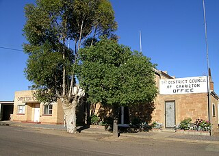
Carrieton is a small town situated in the Flinders Ranges of South Australia. It is located between the towns of Orroroo to the south and Cradock to the north.

Jambin is a town and locality in the Shire of Banana, Central Queensland, Australia.
Dulacca is a town and a locality in the Western Downs Region, Queensland, Australia. At the 2011 census, Dulacca had a population of 249.

Imbil is a town and a locality in the Gympie Region, Queensland, Australia. At the 2011 census, Imbil had a population of 942.

Watchupga is a locality in Northern Victoria, Australia. The local government area of Watchupga is the Shire of Buloke. Watchupga has a grain station on the Mildura railway line with a grain silo on the site which is 84 metres tall. However, the station was closed to passenger and parcels traffic on 11 November 1975. Watchupga Post Office opened on 23 July 1900 and was closed on 29 February 1972.
Curyo is a town in the Mallee Ward of the Shire of Buloke, Victoria, Australia. Curyo has a Grain Depot on the Mildura railway line; however, the station closed to passenger and parcels traffic on 11 November 1975. A CFA fire brigade in the area is located on Pratt Road, adjacent to the grain depot. The post office there opened on 20 January 1900 and was closed on 9 January 1976. Curyo used to have a football club and a golf course.
Karyrie is a town in the Shire of Buloke, Victoria, Australia. Karyrie had a station on the Mildura railway line which is now closed between Kinnabulla station and Birchip station. The post office in the locality opened on 19 November 1892 and was closed on 15 November 1919.

Ballandean is a small town and locality in the Granite Belt Region of the Southern Downs, Queensland, Australia. At the 2016 Australian Census the town recorded a population of 338. The town has a number of nearby vineyards which attracted tourists to the area.

Gogango is a small town and a locality in the Rockhampton Region, Queensland, Australia. At the 2011 census, Gogango and the surrounding area had a population of 310.

Yarrah is a rural locality in the Far North region of South Australia. The eastern section of Yarrah lies within the Flinders Ranges Council, while the western section lies in the Pastoral Unincorporated Area.

Glen Aplin is a locality in the Southern Downs Region, Queensland, Australia.


