The Murray River is Australia's longest river, at 2,508 kilometres (1,558 mi) in length. The Murray rises in the Australian Alps, draining the western side of Australia's highest mountains, and then meanders across Australia's inland plains, forming the border between the states of New South Wales and Victoria as it flows to the northwest into South Australia. It turns south at Morgan for its final 315 kilometres (196 mi), reaching the ocean at Lake Alexandrina.

Irrigation is the application of controlled amounts of water to plants at needed intervals. Irrigation helps to grow agricultural crops, maintain landscapes, and revegetate disturbed soils in dry areas and during periods of less than average rainfall. Irrigation also has other uses in crop production, including frost protection, suppressing weed growth in grain fields and preventing soil consolidation. In contrast, agriculture that relies only on direct rainfall is referred to as rain-fed or dry land farming.

Hume Dam, formerly the Hume Weir, is a major dam across the Murray River downstream of its junction with the Mitta River in the Riverina region of New South Wales, Australia. The dam's purpose includes flood mitigation, hydro-power, irrigation, water supply and conservation. The impounded reservoir is called Lake Hume, formerly the Hume Reservoir. It is a gated concrete gravity dam with four earth embankments and twenty-nine vertical undershot gated concrete overflow spillways.

The Murray–Darling basin is a large geographical area in the interior of southeastern Australia. Its name is derived from its two major rivers, the Murray River and the Darling River. The basin, which drains around one-seventh of the Australian land mass, is one of the most significant agricultural areas in Australia. It spans most of the states of New South Wales and Victoria, the Australian Capital Territory, and parts of the states of Queensland and South Australia. The basin is 3,375 kilometres (2,097 mi) in length, with the Murray River being 2,508 km (1,558 mi) long.

Gwydir River, a major inland perennial river of the Barwon catchment within the Murray-Darling basin, is located in the Northern Tablelands, North West Slopes, and Orana districts of New South Wales, Australia.

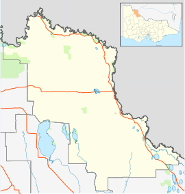
The Goulburn River, a major inland perennial river of the Goulburn Broken catchment, part of the Murray-Darling basin, is located in the alpine, Northern Country/North Central, and Southern Riverina regions of the Australian state of Victoria. The headwaters of the Goulburn River rise in the western end of the Victorian Alps, below the peak of Corn Hill before descending to flow into the Murray River near Echuca, making it the longest river in Victoria at 654 kilometres (406 mi). The river is impounded by the Eildon Dam to create Lake Eildon, the Eildon Pondage, the Goulburn Weir and Waranga Basin.

Wyangala Dam is a major gated rock fill with clay core embankment and gravity dam with eight radial gates and a concrete chute spillway across the Lachlan River, located in the south-western slopes region of New South Wales, Australia. The dam's purpose includes flood mitigation, hydro-power, irrigation, water supply and conservation. The impounded reservoir is called Lake Wyangala.

The Riverland is a region of South Australia. It covers an area of 9,386 square kilometres (3,624 sq mi) along the Murray River from where it flows into South Australia from New South Wales and Victoria downstream to Blanchetown. The major town centres are Renmark, Berri, Loxton, Waikerie, Barmera and Monash, along with many minor townships; the population is approximately 35,000 people.

Blanchetown is a small township in South Australia, on the (west) bank of the Murray River, 130 km northeast of Adelaide. The Blanchetown Bridge is the western-most of the four crossings of the Sturt Highway over the Murray River. During the nineteenth century it was an important transportation centre on the lower Murray. In modern times Blanchetown has been described as "a strange mixture of historic buildings and temporary shacks built by holidaymakers on the banks of the river". Blanchetown is widely regarded as the entrance to the Riverland district.

Lake Mutirikwi, formerly known as Lake Kyle, lies in south eastern Zimbabwe, south east of Masvingo. It is thought to have been named Lake Kyle, from the Kyle farm which occupied most of the land required for the lake, which in turn was named after the Kyle district in Scotland from which the pioneer of the Lowveld, Tom Murray MacDougall came originally. It covers about 90 km² (35 sq mi) and was created in 1960 with the construction of the Kyle Dam on the Mutirikwi River. The dam was built to provide water to the farming estates on the lowveld to the southwest, around the town of Triangle, where the main crop has been sugar cane.

Irrigation is a widespread practice required in many areas of Australia, the driest inhabited continent, to supplement low rainfall with water from other sources to assist in growing crops and pasture. Overuse or poor management of irrigation is held responsible by some for environmental problems such as soil salinity and loss of habitat for native flora and fauna.
The Murray Irrigation Area is geographically located within the Riverina area of New South Wales, between Mulwala and Moulamein. It was created to control and divert the flow of local river and creek systems for the purpose of food production. The main river system feeding and fed by the area is the Murray River.

The environmental impact of reservoirs comes under ever-increasing scrutiny as the global demand for water and energy increases and the number and size of reservoirs increases.

Surface irrigation is where water is applied and distributed over the soil surface by gravity. It is by far the most common form of irrigation throughout the world and has been practiced in many areas virtually unchanged for thousands of years.
Water security in Australia has become a major concern over the course of the late 20th and early 21st century as a result of population growth, severe drought, fears of the effects of global warming on Australia, environmental degradation from reduced environmental flows, competition between competing interests such as grazing, irrigation and urban water supplies, and competition between upstream and downstream users.

The Mulwala Canal is an irrigation canal in the southern Riverina region of New South Wales, Australia. It is the largest irrigation canal in the Southern Hemisphere. The canal, starting at Lake Mulwala, diverts water from the Murray River across the southern Riverina plain to the Edward River at Deniliquin. The channel has an offtake capacity of 10,000 megalitres (ML) per day and annually supplies over 1,000,000 ML to 700,000 hectares in the Murray Irrigation Area.

The Menindee Lakes is a chain of shallow ephemeral freshwater lakes connected to the Darling River to form a storage system. The lakes lie in the far west region of New South Wales, Australia, near the town of Menindee.

Robinvale Irrigation District Section B is a locality which had an irrigation project funded by the Lower Murray Water.
Robinvale Irrigation District Section C is a locality in the local government area of the Rural City of Swan Hill. It had an irrigation project funded by the Lower Murray Water in 2010.
Robinvale Irrigation District Section E is a locality which is in the Rural City of Swan Hill. It had an irrigation project funded by the Lower Murray Water.