The former Royal Air Force Station Kenley, more commonly known as RAF Kenley was an airfield station of the Royal Flying Corps in the First World War and the RAF in the Second World War. It played a significant role during the Battle of Britain as one of the three RAF stations specifically tasked with the defence of London. It is located near Kenley on the edge of Greater London. The site remains in use with the Ministry of Defence, as Kenley Airfield.

Kenley is an area within the London Borough of Croydon and the historic county of Surrey. It is situated south of Purley, east of Coulsdon, north of Caterham and Whyteleafe and west of Sanderstead, and 13 miles (21 km) south of Charing Cross. At the 2011 Census, Kenley had a population of 14,966.
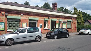
Kenley railway station serves Kenley in the London Borough of Croydon in south London. The station and all trains serving it are operated by Southern, and it is in Travelcard Zone 6, on the Caterham Line 16 miles 29 chains (26.3 km) from London Charing Cross. The station is served by trains from Caterham to Purley, East Croydon, London Bridge and London Victoria. It is the last station on this line located within the Greater London area, however Oyster fares are available up to and including the end of the line at Caterham.

Whyteleafe is a village in the district of Tandridge, Surrey, England, with a few streets falling inside the London Borough of Croydon. The village, in a dry valley of the North Downs, has three railway stations. Neighbouring villages and towns include Woldingham, Caterham, Coulsdon, Warlingham, and Kenley. To the west are Kenley Aerodrome, Kenley Common, Coxes Wood, and Blize Wood. To the east are Riddlesdown, the Dobbin and Marden Park.

Werrimull is a small town and locality in the Rural City of Mildura, part of the Sunraysia region of Victoria. The place by road, is situated about 10 kilometres west of Karawinna and 10 kilometres east of Bambill. It is 79 kilometres (49 mi) west southwest of Mildura, 13 kilometres south of the Sturt Highway opposite Lake Cullulleraine. At the 2016 census, Werrimull and the surrounding area had a population of 112, declining from 320 in 2011.

Patchewollock is a town in north-west Victoria, Australia. At the 2016 census, Patchewollock had a population of 133.

Bungowannah is a locality in the Riverina region of New South Wales, Australia. The locality is on the Riverina Highway, about 16 kilometres (9.9 mi) north west of Albury and 8 kilometres (5.0 mi) south east of Howlong.

Woomargama is a locality in southeastern New South Wales, Australia. The locality is in the South West Slopes region, in the foothills of the Great Dividing Range. It is in the Greater Hume Shire local government area, 508 kilometres (316 mi) south west of the state capital, Sydney and 48 kilometres (30 mi) north east of the regional city of Albury. At the 2006 census, Woomargama had a population of 251.

Carina is a locality in the Rural City of Mildura in Victoria, Australia. It is situated in the Sunraysia region on the Mallee Highway and Pinnaroo railway line. It is situated about 10 kilometres east from Panitya and 14 kilometres west from Murrayville.
Peranga is a rural town and locality in the Toowoomba Region, Queensland, Australia. In the 2016 census the locality of Peranga had a population of 85 people.

Cowangie is a locality situated on the section of the Mallee Highway between Ouyen and the South Australian border in the Sunraysia region of Victoria, Australia. The place by road, is situated about 12 kilometres southeast from Tutye and 12 kilometres northwest from Danyo.

Tutye is a locality situated on the section of the Mallee Highway between Ouyen and the South Australian border in the Sunraysia region of Victoria, Australia. The place by road, is situated about 9 kilometres southeast from Boinka and 12 kilometres northwest from Cowangie.

Postcodes in Australia are used to more efficiently sort and route mail within the Australian postal system. Postcodes in Australia have four digits and are placed at the end of the Australian address, before the country. Postcodes were introduced in Australia in 1967 by the Postmaster-General's Department and are now managed by Australia Post, Australia's national postal service. Postcodes are published in booklets available from post offices or online from the Australia Post website.
Neds Corner is a locality in Victoria, Australia. It is located approximately 31 km from Cullulleraine, Victoria and bordered to the north by the Murray River.

Kenley Geronimo Jansen is a Curaçaoan professional baseball pitcher for the Atlanta Braves of Major League Baseball (MLB). He previously played for the Los Angeles Dodgers.
Wilkur is a locality in the Mount Jeffcot ward of the local government area of the Shire of Buloke and the Warracknabeal ward of the Shire of Yarriambiack, Victoria, Australia. Wilkur post office there opened in 1905, closed on 30 September 1912 reopened on 1 February 1926 and later closed on 27 May 1950. Wilkur South post office opened on 28 June 1920 and was closed on 31 July 1957. Cameron's post office opened on 1 October 1904 renamed Beyal in April 1911 and was closed on 31 August 1929.
Corack East is a locality in the Mount Jeffcott ward of the local government area of the Shire of Buloke, Victoria, Australia. A rural CFA station is located in the town. Corack East post office opened on 1 August 1891 and was closed on 24 May 1976.
The Kenley Players was an Equity summer stock theatre company which presented hundreds of productions featuring Broadway, film, and television stars in Midwestern cities between 1940 and 1996. Variety called it the "largest network of theaters on the straw hat circuit." Founded by and operated for its entire lifespan by John Kenley, it is credited with laying the groundwork for Broadway touring companies.
Wondecla is a rural locality in the Tablelands Region, Queensland, Australia. In the 2016 census Wondecla had a population of 638 people.
Kidaman Creek is a rural locality in the Sunshine Coast Region, Queensland, Australia. In the 2016 census Kidaman Creek had a population of 130 people.